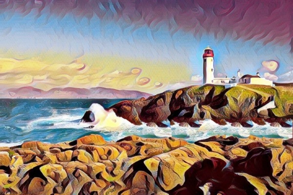
The County Donegal of Ireland and in particular its northern side shore is popularly known as the Fanad, lying between Mulroy Bay and Lough Swilly. Fanad is home to some 700 residents and statistically some thirty percent of them speak Irish. Geographically the parishes of Clondavaddog, Killygarvan and portions of Tullyfern and Aughinish are included inside of Fanad. Although it is specifically not known where the name Fanad originated, it is rumoured to have been etymologically derived from the old Gaelic term Fana, which means sloping ground. The surveyor John O Donovan identified Rathmullan as the Fanad capital in 1835 and comprised of parishes besides Clondavaddog. When the MacSuibhne family ruled Fanad in the sixteenth century, it was said that the region of Fanaid reached far as south as the River Lennon between Kilmacrennan and Ramelton. Over the years, there have been some disagreements regarding what marked the southern border of Fanad. Today it is measured roughly twelve kilometer east-west between the townlands of Doaghbeg and Glinsk and about twenty-five kilometer in the north-south direction from Fanad Head up to the town of Ramelton. Fanad as a habitat is an amalgamation of tiny village communities including Tamney, Rossnakill, and Kerrykeel and also another neighbouring community. The majority of the underlying rocks in the peninsula are Dalradian meta-sedimentary rocks, which have been revealed over thousands of years by erosion and other weathering activities. Regarding its topography, rock alignments can be seen through the Fanad peninsula in the direction from southwest to the northeast on any geological maps of County Donegal. From Ballywhoriskey to Fanad Head, the peninsular northern side has stripes of Granodiorite igneous rocks, but the majority of Fanad geology is made up of Middle-Dalradian Quartzite and some Pellite rocks with isolated spots of Schists and Tillites. Tillites are mostly found around the northern inlet of Mulroy Bay. The elevated ground moving of south from Fanad Head to Portsalon is a basically strip of Quartzite, whereas the cliffs which surround the Fanad Head are made of bare Grandiorite. Yet another quartzite-based mountain is the Knockalla Mountain. Geological processes, including those caused by glaciers and ice sheets recurrently covered the area as recently as fourteen thousand years ago and have resulted in the creation of the terrain of Fanad. Fanad and the adjacent neighbourhood were seriously effected by the withdrawal of the ice sheet. The occurrence of Megalithic court tombs at a number of localities, such as Tyrladden, Drumhallagh Upper, and Crevary Upper, dating most probably from around 4,000 to 3,500 BCE, is most likely the oldest indication of human habitation in Fanad. Neolithic doorway tombs, also otherwise referred to as dolmens, can be found, including examples at Gortnavern, south of Kerrykeel, and above Saltpans, on the Lough Swilly side of the peninsula. These are thought to have been around between 3,800 to 2,200 BCE! [Information Credit : Fanad, Wikipedia ; Link : https://en.wikipedia.org/wiki/Fanad ] [Image: Artistic Depiction of Fanad Lighthouse, County Donegal]
 Art of Heritage