Located in Piazza Bocca della Verità, the ancient Forum Boarium in Rome, Italy, is the Temple of Hercules Victor, also known as Hercules Olivarius. It is a Roman temple. It is a tholos, a circular temple with a colonnade encircling it and a Greek Peripteral style. Due to its layout, it was mistaken for a Vesta temple until Camille de Tournon, Prefect of Rome of Napoleon, made the precise identification. There is a folktale that says that neither dogs nor flies will be allowed into the Temple of Hercules, even though the Forum Boarium served as livestock market of Rome in antiquity. The temple is the oldest largely intact marble structure still standing in Rome and is the sole one composed of Greek marble. Built in the latter part of the 2nd century BC, either by Marcus Octavius Herrenus or L. Mummius Achaicus—the conqueror of the Achaeans and the annihilator of Corinth—the temple has a diameter of 14.8 meters and is made up of a circular cella surrounded by a concentric ring of twenty Corinthian columns. Nineteen of the twenty initial columns and the original travertine of the cella and marble block wall still stand; the tile roof that is currently in place was put in later. Ten columns in the temple were substituted with Luna marble in the first century AD, following some type of calamity. The marble was a close but not perfect reproduction of the predecessor. The temple was transformed into Santo Stefano alle Carozze, a church, around 1132. The temple was further transformed into a Christian church and dedicated to Santo Stefano by Innocent II in 1140. The church was re-dedicated to Santa Maria del Sole in the seventeenth century. The neighboring surface was reduced and the temple was renovated once more between 1809 and 1810. 1935 saw the temple being officially designated as an ancient monument, and in 1996 it underwent restoration.
#History#Architecture
This article also uses an image from the Wikipedia article -- Temple_of_Hercules_Victor --
[Wikipedia-Article-Link : https://en.wikipedia.org/wiki/Temple_of_Hercules_Victor ]
[Image : The Hercules Victor Temple, located in the Forum Boarium; Wikipedia-Image-Author : ChromosomeGun]
[Wikipedia-Image -Link : https://en.wikipedia.org/wiki/File:Temple_of_Hercules_Victor_Rome_April_2019.jpg ]
[Image Availed Under Creative Commons Attribution-Share Alike 4.0 International License;]
[License-Link : https://creativecommons.org/licenses/by-sa/4.0/deed.en ] [You may copy, distribute and transmit the work (image) or share (alike) the work (image), provided that you comply with the terms of the Creative Commons Attribution-Share Alike 4.0 International License or other compatible license in distribution]
[License-Link : https://creativecommons.org/licenses/by-sa/4.0/deed.en ]
[Please Also Relate to Original Individual Text and Image URLs for More Usage Property and Sharing, Remixing or Attributing the Contents]
[Contents on Wikipedia is covered by -- Disclaimer --
[Wikipedia-Disclaimer-Link : https://en.wikipedia.org/wiki/Wikipedia:General_disclaimer ] [Contents in this Website is also covered by Disclaimer linked at the bottom of the Page]
[This website article means no intellectual appropriation by any way and only wishes to contribute in sharing of knowledge]
Discovered on Pagans Hill at Chew Stoke in the English county of Somerset, the Pagans Hill Roman Temple was a Romano-British type structure. Presumably dedicated to the god Mercury, the temple was originally constructed in the late third century and headed east. Second temple was constructed after the previous structure collapsed, but it too collapsed and fell into ruin. An interior screen was added in the last reconstruction, which took place after roughly 367 CE. The most current dateable coin was of Arcadius, 383–408, and was discovered at the location. The fifth century saw the fall of the last structure. The temple is located on what is appropriately called Pagans Hill, however the name of the road has no connection to the temple and is a more recent addition. This double-octagonal temple structure had an outside wall that formed an ambulatory, or enclosed passageway, and an interior wall that constituted the cella, or sanctuary. Each wall was roughly three feet thick. Two elements that Rahtz identified as buttresses were located alongside each wall; however, given their tiny size, it is more probable that they were pilasters. Together with the octagonal temple and sacred spring, the location created a sizable pilgrimage centre complete with lodgings for guests and residence of a priest. A peculiar sculpture of a dog wearing a collar was discovered in the well, which was located about 15 meters to the west of the temple footings, among other artifacts. A bucket and an unusual glass jar from the 7th century that were discovered in the well provide proof that the area was still in use after the Roman era. When the temple was first discovered in 1830, it was believed to have served as a beacon for indicating between nearby hill forts. #History#Architecture
This article also uses an image from the Wikipedia article -- Pagans_Hill_Roman_temple --
[Wikipedia-Article-Link : https://en.wikipedia.org/wiki/Pagans_Hill_Roman_temple ]
[Image : A reconstructed drawing of the Roman Temple at Pagans Hill; Wikipedia-Image-Author : Willythesqueeze at English Wikipedia]
[Wikipedia-Image -Link : https://en.wikipedia.org/wiki/File:Paganreconstruction_(2).gif ]
[The Work (Image) has been released into the public domain by its author, Willythesqueeze at English Wikipedia. This applies worldwide. In some countries this may not be legally possible; if so:
Willythesqueeze grants anyone the right to use this work for any purpose, without any conditions, unless such conditions are required by law.] [Please Also Relate to Original Individual Text and Image URLs for More Usage Property and Sharing, Remixing or Attributing the Contents]
[Contents on Wikipedia is covered by -- Disclaimer --
[Wikipedia-Disclaimer-Link : https://en.wikipedia.org/wiki/Wikipedia:General_disclaimer ] [Contents in this Website is also covered by Disclaimer linked at the bottom of the Page]
[This website article means no intellectual appropriation by any way and only wishes to contribute in sharing of knowledge]
The Będzin Castle is located in the southern Polish city of Będzin. The wooden stronghold, which was built in the eleventh century, predates the forteenthth-century stone castle. It served as a crucial defense for the Polish Kingdom and, subsequently, for the Polish-Lithuanian Commonwealth. The origins of Będzin village date back to the ninth century. The wooden fort in the area, which dates back to the eleventh century according to documents, was destroyed in 1241 during the Tatar invasion and then again reconstructed. The timber fortification was replaced by a stone castle during the reign of Casimir III the Great. As early as 1348, the stone castle was in use. Not long afterward, in 1358, the burgeoning trading settlement of Bytom was granted city powers under the Magdeburg Law. The castle was intended to serve as a military outpost on the southwest frontier of the Kingdom of Poland and later the Polish-Lithuanian Commonwealth. It was the furthest westward stronghold, designed to fend off any assault from Bohemian or Silesian areas toward Lesser Poland. The castle was visited in 1364 by the Holy Roman Emperor Charles IV. Maximilian III, the Archduke of Austria, was imprisoned here in 1588 following his loss in the 1587–1588 War of the Polish Succession. The late 16th century saw the fortress fall into decay. The further devastation was caused by the fire in 1616 and the damage sustained during The Deluge in 1657. Although the stronghold was regularly restored, its significance diminished as frontiers of Poland and its ties with its neighbors changed. Following the division of Poland, Prussian rule over Będzin resulted in the Hohenzollern dynasty gaining ownership of the castle. The adjacent areas were given to the Duchy of Warsaw in 1807 and the Congress of Poland in 1815. When a stone fragment squashed a bystander in 1825, the nearly collapsing castle was directed to be demolished. However, the castle was designated as a monument before any work was done on it. Count Edward Raczyński purchased the castle in the 1830s, had it largely renovated, and briefly placed a Protestant chapel therein. However, after Raczyński passed away in 1845, hopes to construct an academy or hospital there were shelved, and the castle once more fell into neglect. It was not until the Peoples Republic of Poland, from 1952 to 1956, that the castle was reconstructed and turned into a museum. #History#Architecture#Castles
This article also uses an image from the Wikipedia article -- Będzin_Castle –
[Wikipedia-Article-Link : https://en.wikipedia.org/wiki/B%C4%99dzin_Castle ]
[Image : Będzin Royal Castle; Wikipedia-Image-Author : Geociekawostki]
[Wikipedia-Image -Link : https://en.wikipedia.org/wiki/File:Zamek_w_B%C4%99dzinie_1.JPG ]
[Image Availed Under Creative Commons Attribution-Share Alike 3.0 Poland License;]
[License-Link : https://creativecommons.org/licenses/by-sa/3.0/pl/deed.en ] [You may copy, distribute and transmit the work (image) or share (alike) the work (image), provided that you comply with the terms of the Creative Commons Attribution-Share Alike 3.0 Poland License or other compatible license in distribution]
[License-Link : https://creativecommons.org/licenses/by-sa/3.0/pl/deed.en ]
[Please Also Relate to Individual Text and Image URLs for More Usage Property and Sharing, Remixing or Attributing the Contents]
[Contents on Wikipedia is covered by -- Disclaimer --
[Wikipedia-Disclaimer-Link : https://en.wikipedia.org/wiki/Wikipedia:General_disclaimer ] [Contents in this Website is also covered by Disclaimer linked at the bottom of the Page]
[This article means no intellectual appropriation by any way and only wishes to contribute in sharing of knowledge]
Situated in the village of Carisbrooke on the Isle of Wight in England, Carisbrooke Castle is a historic motte and bailey castle. In the months leading up to his trial, Charles I was held captive at the castle. There may have been pre-Roman habitation on the site of Carisbrooke Castle. There may have been a building there in late Roman times based on the remains of a wall. Wihtgar, the cousin of King Cynric of Wessex, is said to have died in AD 544 and was buried there according to the Anglo-Saxon Chronicle. By the late 7th century, the fort might have been occupied by the Jutes. The location was home to an Anglo-Saxon stronghold in the eighth century. In order to protect the hill against Viking incursions, a wall was constructed around it circa AD 1000. Family of Richard de Redvers owned the castle from 1100 until his descendants enhanced it with stone walls, towers, and a keep during the course of the following two centuries. Edward I purchased the castle in 1293 from the last Redvers inhabitant, Countess Isabella de Fortibus. From that point on, wardens, acting as delegates of the monarch, were given control over it. During rule of Richard II in 1377, the French attempted an unsuccessful raid on the fortress. The story goes that Peter de Heyno, a local hero, shot the French commander and saved it. In 1467, Anthony Woodville, the future Earl Rivers was granted the castle and the Lordship. During era of Henry I, the keep was erected to the castle, and during reign of Elizabeth I, Sir George Carey, who had been appointed Governor of the Isle of Wight in 1583, fortified it further when the Spanish Armada was anticipated. Later, Carey hired Federigo Giambelli, an Italian engineer, to strengthen the defenses even more. Beginning in 1597, Giambelli built a contemporary trace Italienne fortress that encircled the old castle and bailey entirely. It consisted of a squat rampart and ditch, periodically reinforced by strong bastions. Before his execution in 1649, Charles I spent fourteen months in prison here. Princess Beatrice, the daughter of Queen Victoria, lived there as the Governor of the Isle of Wight from 1896 until 1944. English Heritage is presently in charge of it [Information and Image Credit : Carisbrooke_Castle, Wikipedia] [Wikipedia-Link : https://en.wikipedia.org/wiki/Carisbrooke_Castle ] [Image : The interior of Carisbrooke Castle; Wikipedia-Image-Author : Geni] [Image Availed Under Creative Commons Attribution-Share Alike 4.0 International License; (Please Relate to Individual Image URLs for More Usage Property and Sharing, Remixing or Attributing the Work)] [License-Link : https://creativecommons.org/licenses/by-sa/4.0/deed.en ] [Original Wikipedia-Image-Source-Link : https://en.wikipedia.org/wiki/File:Carisbrooke_castle_buildings_2023.JPG ] #History#Architecture#Castles
The Greek word for cavalry is hippeis. Following political reforms by Solon, the hippeus ranked second among the four social classes in ancient Athens. It was made up of guys whose yearly income was at least 300 medimnoi or comparable. As to the Timocratic Constitution, the mean annual income of the populace was below 200 medimnoi. This allowed the men who earned 300 medimnoi to buy and keep a war horse while they worked for the government. The Roman equites and the medieval knights were its equivalents. The hippeus served as the regal guard of honor in Sparta. There were three hundred young Spartans under thirty in it. Following the Greco-Persian War in the fifth century BC, the Athenian cavalry was established. Its initial strength was 300 soldiers, but after Golden Age of Athens, it grew to 1,200 soldiers. This comprised 1,000 Athenians and 200 mounted bowmen. In periods of peace, the hippeus kept drilling. They participated in processions at open-air festivities as well. The levy was overseen by two hipparchi who commanded them. Five phylarchi, each in charge of a phyla, were subordinate to each hipparch. The two top courses produced both sets of officers. The boule, or council, had the responsibility of ensuring that the cavalry was in excellent working order and screening incoming recruits for eligibility and equipment. The decision of the popular assembly set the number of riders to be deployed. Upon enlisting, each horseman was granted equipment funds and a subsidy for maintaining a groom and two horses; this eventually developed into an annual grant from the state totaling forty talents; nonetheless, regular compensation was only provided in the field [Information and Image Credit : Hippeis; Wikipedia] [Wikipedia-Link : https://en.wikipedia.org/wiki/Hippeis ] [Image : A black-figured Laconian cup by Rider Painter with a hippeus figure on it; Wikipedia-Image-Author : Jastrow (2006)] [The copyright holder of the work (Image), released the work into the public domain. This applies worldwide. In some countries this may not be legally possible; if so: The copyright holder grant anyone the right to use this work for any purpose, without any conditions, unless such conditions are required by law; (Please Relate to Individual Image URLs for More Usage Property and Sharing, Remixing or Attributing the Work)] [Original Wikipedia-Image-Source-Link : https://en.wikipedia.org/wiki/File:Rider_BM_B1.jpg ] #History#Art
Situated in Granada, Andalusia, Spain, the Alhambra is a complex of palaces and fortifications. Muhammad I Ibn al-Ahmar, the first Nasrid emir and the founder of the Emirate of Granada, started construction on the complex in 1238. It was constructed on the Sabika hill, an offshoot of the Sierra Nevada that had previously hosted forts and palace of Samuel ibn Naghrillah from the eleventh century. The location was repeatedly altered by later Nasrid monarchs. The greatest building projects, which contributed significantly to the defining characteristics of royal palaces, were carried out in the fourteenth century under Yusuf I and Muhammad V. The Alhambra was a stand-alone city apart from the rest of Granada during the Nasrid dynasty. It was a royal city and fortification with at least six great palaces, the most of which overlooked the Albaicín sector from their location along the northern perimeter. The Mexuar, Comares Palace, Palace of the Lions, and Partal Palace are the most well-known and well-preserved, and they serve as the primary draw for tourists today. Both contemporary excavations and historical records provide information on the other palaces. Afterwards, the palaces underwent some modifications and the location became the Royal Court of Ferdinand and Isabella. Charles V ordered a new palace in the Renaissance style in 1526 to be built in stark contrast to the Nasrid palaces, but it was abandoned in the early 17th century. Following defeat of Napoleon I, when his forces demolished portions of the site, the Alhambra was found after being abandoned for years and its structures occupied by squatters. Initially, British intellectuals led the rediscovery efforts, followed by other American and Northern European Romantic explorers. Washington Irving was the most significant of them all; his Tales of the Alhambra, published in 1832, made the location famous around the world. Known for its remarkable instances of Spanish Renaissance architecture, it is also one of the most well-known monuments of Islamic architecture and one of the best-preserved palaces of the old Islamic world. It is one of the most famous monuments of Islamic architecture and one of the best-preserved palaces of the historic Islamic world, in addition to containing notable examples of Spanish Renaissance architecture. [Information and Image Credit : Alhambra, Wikipedia] [Wikipedia-Link : https://en.wikipedia.org/wiki/Alhambra ] [Image : Dawn on Charles V palace in Alhambra, Granada, Spain; Wikipedia-Image-Author : Jebulon] [The Image (file) is made available under the Creative Commons CC0 1.0 Universal Public Domain Dedication. The person who associated a work with this deed has dedicated the work to the public domain by waiving all of their rights to the work worldwide under copyright law, including all related and neighboring rights, to the extent allowed by law. One can copy, modify, distribute and perform the work, even for commercial purposes, all without asking permission (Please Relate to Individual Image URLs for More Usage Property and Sharing, Remixing or Attributing the Work)] [License-Link : https://creativecommons.org/publicdomain/zero/1.0/deed.en ] [Original Wikipedia-Image-Source-Link : https://en.wikipedia.org/wiki/File:Dawn_Charles_V_Palace_Alhambra_Granada_Andalusia_Spain.jpg ] #History#Architecture#Castles
Rome, Italy is home to the ancient Roman temple known as the Temple of Portunus. It was constructed next to the Forum Boarium, the ancient Roman cattle market connected to Hercules, which was next to the Pons Aemilius, the oldest stone bridge over the Tiber River and oldest river port of Rome. Given that there were multiple other temples in the vicinity in addition to Portunus, the exact dedication is still unknown, but it was most likely made in honor of the gateway deity. It is still more often known by this name despite being mistakenly labeled as the Renaissance Temple of Fortuna Virilis. Of all the Roman temples, this one is among the best preserved. It is the primary temple in the city devoted to Portunus, the deity of keys, doors, animals, and therefore granaries. The temple was transformed into a Christian church honoring Santa Maria Egyziaca throughout the Middle Ages. Up until the early 20th century, it was still a church. However, at that time, it was deconsecrated, all later alterations removed, and its classical aspect was restored as an archeological monument. As part of its repair, nearby buildings from the Renaissance and Middle Ages were demolished. Located in the historic Forum Boarium by the Tiber, the Ionic Temple had a commanding view of the Tiberine harbor during antiquity, where Portunus kept watch over cattle barges arriving in the city from Ostia. The temple was renovated between 120 and 80 BC, having been constructed in the third or fourth century BC. Its rectangular structure, which is still intact, is made up of a tetrastyle portico and cella, erected on a high podium that is accessed by stairs. Its pronaos portico, which has two columns deep and four Ionic columns across, is reminiscent of the Maison Carrée in Nîmes. The columns of the portico are free-standing, while the four columns at the back and the other five on the long sides are half-columns that are positioned against the walls of the cella [Information and Image Credit : Temple_of_Portunus, Wikipedia] [Wikipedia-Link : https://en.wikipedia.org/wiki/Temple_of_Portunus ] [Image : Temple of Portunus in the Forum Boarium; Wikipedia-Image-Author : WikiRomaWiki] [Image Availed Under Creative Commons Attribution-Share Alike 4.0 International License; (Please Relate to Individual Image URLs for More Usage Property and Sharing, Remixing or Attributing the Work)] [License-Link : https://creativecommons.org/licenses/by-sa/4.0/deed.en ] [Original Wikipedia-Image-Source-Link : https://en.wikipedia.org/wiki/File:Temple_of_Portunus.jpg ] #History#Art#Architecture
Situated in the Beqaa Valley in Lebanon, the Temple of Bacchus is a part of the Baalbek archeological site. The temple complex was added to the UNESCO World Heritage List in 1984 and is regarded as an exceptional archaeological and artistic example of Imperial Roman architecture. One of the most magnificent and well-preserved Roman temple remains is this monument to Bacchus. Although its exact age is unclear, its exquisite decoration may be traced back to the second century CE. The Roman Emperor Antoninus Pius, who ruled from AD 138 to AD 161, most likely ordered the temple. The site was unknown until the Greeks conquered it in the fourth century, by which time the temple had probably closed because of the persecution of pagans in the late Roman Empire. Not until 1898–1903 did a German mission start excavating two of the larger temples and rebuilding the area. The Lebanese government ordered the preservation of the site and renovations in 1920 following the proclamation of the State of Greater Lebanon. Protection of the site was discontinued after the Lebanese civil war broke out in the mid-1970s and Al-Biqā turned into a stronghold for Syrian and Palestinian forces. The Baalbek ruins were added to the UNESCO World Heritage List in 1984. After the war ended in the 1990s, the place started to be preserved. Measuring 66 meters in length, 35 meters in width, and 31 meters in height, the temple is marginally smaller than the Temple of Jupiter. The temple is situated on a podium that runs east-west. A colonnade of forty-two unfluted Corinthian columns with Ionic bases, nineteen of which remain intact, adorns the periphery wall. Inside, two levels of niches on either side are flanked by Corinthian pilasters that adorn the cella. Even upto the sixteenth century, the gateway itself remained intact. Numerous archaeological excavations and studies on The Temple of Bacchus and the complete temple complex have been conducted by the Orient Department of the German Archaeological Institute. Research and evaluation of the site are ongoing. Examples include recording sculptures and reliefs, studying the fauna found in the ruins through the lens of archaeozoology, and examining urban growth and its connection to Baalbek [Information and Image Credit : Temple_of_Bacchus, Wikipedia] [Wikipedia-Link : https://en.wikipedia.org/wiki/Temple_of_Bacchus ] [Image : Temple of Bacchus; Wikipedia-Image-Author : Jan Hilgers] [Image Availed Under Creative Commons Attribution-Share Alike 3.0 Unported License; (Please Relate to Individual Image URLs for More Usage Property and Sharing, Remixing or Attributing the Work)] [License-Link : https://creativecommons.org/licenses/by-sa/3.0/deed.en ] [Original Wikipedia-Image-Source-Link : https://en.wikipedia.org/wiki/File:Baalbek_Baccustempel.jpg ] #History#Art#Architecture
Located in the southern French city of Nîmes, the Maison carrée is one of the best-preserved Roman temples still standing in the former Roman Empire. It is a caesareum, a medium-sized Augustan provincial temple of the Imperial religion. The Maison carrée was re-dedicated to Gaius and Lucius Caesar, the adoptive grandsons and heirs of Augustus who both passed away at a young age, in the years 4-7 AD. In the Middle Ages, the inscription honoring Gaius and Lucius was erased from the temple. Nonetheless, in 1758, a scholar from the area named Jean-François Séguier managed to piece together the inscription by counting the holes on the front frieze and architrave, which were used to hold the bronze letters that were attached with protruding tines. Victor Grangent helped the temple gradually regain its former splendor during the 19th century. Despite using the Corinthian order, the Maison carrée resembles a Roman temple in the Tuscan style as described by the contemporary Roman architect Vitruvius. The neoclassical Église de la Madeleine in Paris, the St. Marcellinus Church in Rogalin, Poland, and the Virginia State Capitol of United States—designed by Thomas Jefferson, who had a stucco replica of the Maison carrée made while serving as minister of France in 1785—were all influenced by the Maison carrée. The Maison carrée of Nîmes was added to the UNESCO World Heritage List in September 2023 [Information and Image Credit : Maison_carrée, Wikipedia] [Wikipedia-Link : https://en.wikipedia.org/wiki/Maison_carr%C3%A9e ] [Image : Front view of the Temple; Wikipedia-Image-Author : Fabhuard] [Image Availed Under Creative Commons Attribution-Share Alike 4.0 International License; (Please Relate to Individual Image URLs for More Usage Property and Sharing, Remixing or Attributing the Work)] [License-Link : https://creativecommons.org/licenses/by-sa/4.0/deed.en ] [Wikipedia-Image-Source-Link : https://en.wikipedia.org/wiki/File:Maison_carr%C3%A9e_(3).jpg ] #History#Art#Architecture
Henry VIII built Pendennis Castle, an artillery fort, in the vicinity of Falmouth, Cornwall, England, between 1540 and 1542. As a component of the Kings Device initiative, it safeguarded the Carrick Roads waterway at the mouth of the River Fal from French and Holy Roman Empire invasions. The earlier castle was surrounded by a ring of substantial stone ramparts and bastions by the end of the century to fend off the growing Spanish threat. The original, circular keep and gun platform was retained. Pendennis was held by the Royalists during the English Civil War and was only captured by Parliament in 1646 following an extended siege. After Charles II was reinstated in 1660, he restored the fortress, which had withstood the interregnum. Defenses of Pendennis were updated and modernized in the 1730s and 1790s because to persistent fears of a potential French invasion; the castle could have up to 48 guns during the Napoleonic Wars. In order to bolster these defenses, new, fast-firing guns were added in the 1880s and 1890s. An electrically driven minefield was also erected across the River Fal, controlled from Pendennis and St Mawes. After being rearmed during World War I but seeing no action, the castle was rearmed again during World War II and saw battle against German Luftwaffe aircraft. By 1956, however, the castle had become obsolete and was dismantled. The Ministry of Works took over management of the site, demolishing several of the more contemporary military structures and making it accessible to the public. English Heritage is in charge of running the castle as a tourist destination in the twenty-first century. Pendennis is regarded by the heritage organization Historic England as one of the best specimens of a post-medieval defensive promontory fort in the nation [Information and Image Credit : Pendennis_Castle, Wikipedia] [Wikipedia-Link : https://en.wikipedia.org/wiki/Pendennis_Castle ] [Image : 16th-century gun platform and keep; Wikipedia-Image-Author : Willhsmit] [The copyright holder of this work, have released this work into the public domain. This applies worldwide (Please Relate to Individual Image URLs for More Usage Property and Sharing, Remixing or Attributing the Work)] [Wikipedia-Image-Source-Link : https://en.wikipedia.org/wiki/File:Pendennis_Castle.jpg ] #History#Art#Architecture#Castles
The medieval castle and palace complex of the Hungarian kings is located in Budapest and is known as Buda Castle. Although the huge Baroque palace that now occupies most of the site was built between 1749 and 1769, the original construction was completed in 1265. The building complex used to be known as the Royal Castle or the Royal Palace. The Budapest Historical Museum and the Hungarian National Gallery are currently located within the castle. Buda Castle is located on the southernmost point of Castle Hill and is encircled by the popular tourist destination of Várnegyed, which is well-known for its churches, monuments, homes, and structures from the Middle Ages, Baroque, and Neoclassical periods. The Castle Hill Funicular connects the hill to Clark Ádám Square and the Széchenyi Chain Bridge. In 1987, the castle was officially designated as a part of the Budapest World Heritage Site. During the Kádár era, the original Royal Palace was reconstructed in a simplified Stalinist Baroque design after being destroyed during World War II. King Béla IV of Hungary constructed the first royal home atop Castle Hill between 1247 and 1265. It is unclear if it was located close to the Kammerhof on the northern elevation or at the southernmost point of the hill. Younger brother of King Louis I of Hungary, Stephen, Duke of Slavonia, constructed the earliest portion of the current palace in the fourteenth century. The foundation of the castle keep are all that are left. Gothic residence of King Louis I was set around a small courtyard next to the fortress. King Sigismund upgraded the defenses of the palace and greatly expanded it. As the Holy Roman Emperor, Sigismund required an opulent palace to symbolize his importance among the rulers of Europe. During his lengthy rule, he made Buda Castle his principal residence, and it grew to be arguably the biggest Gothic palace of the late Middle Ages. A significant hub for the artistic development of the International Gothic style was Buda. Large-scale construction activity peaked during the reign of King Matthias Corvinus. The king completed construction on the Gothic palace in the first several decades of his reign. That is probably when the Royal Chapel and the Lower Church that still stand were constructed. Italian humanists, artists, and craftsmen came to Buda with the marriage of Matthias and Beatrice of Naples in 1476. The capital of Hungary developed into the first Renaissance hub north of the Alps. The palace was reconstructed by the king in the early Renaissance style. The humanists in the court of of Matthias Corvinus typically associated him with Hercules; panels illustrations of the exploits of the Greek hero adorned the bronze gates, and a massive bronze statue of the hero greeted visitors in the forecourt of the palace complex, the site of jousts. The palace was restored during reign of King John Zápolya. Italian military engineers constructed the Great Rondella on the southernmost point of Castle Hill. One of the primary remnants of the former palace is the circular bastion [Information and Image Credit : Buda_Castle, Wikipedia] [Wikipedia-Link : https://en.wikipedia.org/wiki/Buda_Castle ] [Image : Buda Castle; Wikipedia-Image-Author : Marc Ryckaert (MJJR)] [Image is availed under Creative Commons Attribution 3.0 Unported License; (Please Relate to Individual Image URLs for More Usage Property and Sharing, Remixing or Attributing the Work)] [License-Link : https://creativecommons.org/licenses/by/3.0/deed.en ] [Wikipedia-Image-Source-Link : https://en.wikipedia.org/wiki/File:Budapest_Castle_R02.jpg ] #Castles#History
Located 16 km northeast of Melton Mowbray and 10 km west of Grantham, Leicestershire, England, Belvoir Castle is a beautiful residence and faux historic castle. On this location, a castle was first constructed soon after the Norman Conquest in 1066, and it has subsequently undergone at least three reconstructions. The last structure is an early 19th-century imitation castle that is listed on grade I. David Manners, the 11th Duke of Rutland, inherited it in 1508 through a straight male line. It is his residence. The Manners family was originally buried in the parish church of St. Mary the Virgin in Bottesford, but since 1825, their historic remains have been transported to the ducal mausoleum that was constructed near to the castle in that same year. Although it is accessible to the public, the Duke of Rutland still owns it privately. The castle is located in the most northern point of Leicestershire County, overlooking the Vale of Belvoir on the Nottinghamshire border to the northwest. It is surrounded by Lincolnshire County to the east and Nottinghamshire County to the west. The settlements of Bottesford, Woolsthorpe, Knipton, Harston, Harlaxton, Croxton Kerrial, and Redmile encircle it. Originally, a Norman fortress dominated both the nearby wapentake of Winnibriggs in Lincolnshire and the high ground inside the wapentake of Framland. Until Robert de Ros received Belvoir as a grant in 1257, it was a royal manor. The Norman fortress was noted to be in ruins by 1464. Thomas Manners, 1st Earl of Rutland, began building a massive Tudor manor house in 1528. 1555 saw its completion. It was one of the more prominent strongholds of the supporters of the king during the English Civil War, and King Charles stayed the night here when traveling into Lincolnshire. Because the family backed the Royalists, Parliamentarians destroyed the Tudor structure in 1649. Many artistic creations can be found within the publicly accessible castle. The opulent state rooms—the most well-known of which are the Elizabeth Saloon, the Regents Gallery, and the State Dining Room, which is decorated in a Romanesque style—are the highlights of the tour [Information and Image Credit : Belvoir_Castle, Wikipedia] [Wikipedia-Link : https://en.wikipedia.org/wiki/Belvoir_Castle ] [Image : Belvoir Castle; Wikipedia-Image Author : Jerry Gunner from Lincoln, UK] [Image is availed under Creative Commons Attribution 2.0 Generic License; (Please Relate to Individual Image URLs for More Usage Property and Sharing, Remixing or Attributing the Work)] [License-Link : https://creativecommons.org/licenses/by/2.0/deed.en ] [Wikipedia-Image-Source-Link : https://en.wikipedia.org/wiki/File:Belvoir_Castle.jpg ] #Castles#History
São Pedro de Penaferrim, in the municipality of Sintra, on the Portuguese Riviera, is home to the Romanticist Pena Palace. Perched on a peak in the Sintra Mountains, overlooking the town of Sintra, the castle is plainly visible from Lisbon and a large portion of the metropolitan area on a clear day. It is a national monument and one of the most significant examples of Romanticism from the 19th century worldwide. The palace is one of Seven Wonders of Portugal and a UNESCO World Heritage Site. The President of the Portuguese Republic and other government authorities also utilize it for formal events. The history of the castle began in the Middle Ages with the construction of a chapel devoted to Our Lady of Pena on the hill overlooking Sintra. Tradition has it that building started following a vision of the Virgin Mary. In order to fulfill a commitment, King John II traveled to the location in 1493 with his wife, Queen Leonor. King Manuel I, who succeeded him, had a great affection for this sanctuary as well. He gave the Order of Saint Jerome the order to build a monastery there. For centuries Pena was a modest, sedate retreat for monks, with room for no more than eighteen. Lightning struck the monastery in the 18th century, causing significant damage. But it was the Great Lisbon Earthquake of 1755, which happened not long after, that severely damaged the monastery and left it in ruins. Even though the remains were abandoned for many years, young Prince Ferdinand was nonetheless in awe of them. As King Consort Ferdinand II, he made the decision in 1838 to purchase the old monastery, the surrounding territories, the Castle of the Moors, and a few other local estates. The Portuguese royal family would use the remnants of the monastery as a vacation house, thus King Ferdinand set out to build a palace on their site. Wilhelm Ludwig von Eschwege, a mining engineer and lieutenant general, was tasked with overseeing the reconstruction of the Romantic style. Being a well-traveled amateur architect from Germany, Eschwege probably knew a number of castles along the Rhine. Although it was nearly finished in 1847, the construction was completed between 1842 and 1854. There was significant intervention on questions of decoration and symbolism by King Ferdinand and Queen Maria II. The Portuguese State bought the palace in 1889, and following the Republican Revolution of 1910, it was designated as a national monument and turned into a museum. Before going into exile, Queen Amélia, the last monarch of Portugal, spent her final night at the palace [Information and Image Credit : Pena_Palace, Wikipedia] [Wikipedia-Link : https://en.wikipedia.org/wiki/Pena_Palace ] [Image : Palácio da Pena; Wikipedia-Image Author : www.GlynLowe.com from Hamburg, Germany] [Image is availed under Creative Commons Attribution 2.0 Generic License; (Please Relate to Individual Image URLs for More Usage Property and Sharing, Remixing or Attributing the Work)] [License-Link : https://creativecommons.org/licenses/by/2.0/deed.en ] [Wikipedia-Image-Source-Link : https://en.wikipedia.org/wiki/File:Pena_National_Palace_-_Sintra_-_Pal%C3%A1cio_Nacional_da_Pena_(15842491914)_(cropped).jpg ] #Castles#History
The official residence and office of the president of the Czech Republic is Prague Castle, a collection of castles located in Prague, Czech Republic. Constructed in the ninth century, the castle has long been the official residence of Bohemian monarchs, Holy Roman emperors, and Czechoslovak presidents. As a result, the president, his advisers, and his staff are frequently referred to as the Prague Castle, the Castle, or the Hrad. It has a secret room that holds the Bohemian Crown Jewels. Prague Castle, which spans about 70,000 square meters, is the biggest old castle in the world, according to the Guinness Book of Records. With more than 1.8 million tourists a year, the castle is one of most popular tourist destinations of Prague. Bohemian King Ottokar II strengthened defences and reconstructed the royal palace for housing and representation. During rule of Charles IV in the fourteenth century, the fortifications of the castle were reinforced and the royal residence was reconstructed in the Gothic style. The rotunda and basilica of St. Vitus were replaced by the beginnings of a massive Gothic church, which was finished nearly six centuries later. The castle was abandoned during the Hussite Wars and the decades that followed. Vladislaus II Jagiellon, King of Poland, started restoring the fortress in 1485. The Royal Palace was expanded to include the imposing Vladislav Hall. On the north side of the castle, more defence towers were constructed. Large portions of the castle were destroyed in a massive fire in 1541. A few new Renaissance-style buildings were erected during the Habsburg dynasty. For his wife Anne, Ferdinand I constructed the Belvedere as a summer holiday residence. Prague Castle served as primary residence of Rudolph II. He built the Spanish Hall, the centre piece of the northern wing of the palace, which housed his priceless art holdings. The Bohemian Revolt began at the castle during the Third Defenestration of Prague in 1618. The fortress suffered damage and decay during the ensuing battles. During the decisive Battle of Prague at the time of Thirty Years War in 1648, many pieces of collection from Rudolph II were pillaged by Swedes. In the latter part of the 18th century, Empress Maria Theresa completed the final significant reconstruction of the castle. Prague Castle was the palace of the previous emperor Ferdinand I, who abdicated in 1848 and was succeeded to the throne by his nephew Franz Joseph [Information and Image Credit : Prague_Castle, Wikipedia]
[Wikipedia-Link : https://en.wikipedia.org/wiki/Prague_Castle ] [Image : Prague_Castle; Wikipedia-Image Author : Tilman2007] [Image is availed under Creative Commons Attribution-Share Alike 4.0 International License; (Please Relate to Individual Image URLs for More Usage Property and Sharing, Remixing or Attributing the Work)]
[License-Link : https://creativecommons.org/licenses/by-sa/4.0/deed.en ]
[Wikipedia-Image-Source-Link :
https://en.wikipedia.org/wiki/File:Karl%C5%AFv_most_Praha,_Star%C3%A9_M%C4%9Bsto_20170810_007.jpg ] #Castles#History
Three stone circles surround the Neolithic henge monument known as Avebury, which is located in Wiltshire, southwest England around the village of Avebury. The largest megalithic stone circle in the world can be found at this, one of the most well-known prehistoric sites in Britain. For modern pagans, it is a site of religious significance in addition to being a popular tourist destination. The Neolithic, or New Stone Age, monument was built over several hundred years during the third millennium BC. It consists of a massive henge with two smaller stone circles inside the center of the monument and a larger outer stone circle. Although archaeologists are unsure of its initial use, they assume it was probably part of a ritual or ceremony. The Avebury monument is a portion of a broader prehistoric landscape that also includes West Kennet Long Barrow, Windmill Hill and Silbury Hill, three neighboring older monuments. Although there was minor evidence of human habitation throughout the Roman era, the site had essentially been abandoned by the Iron Age. A hamlet was first constructed around the monument in the Early Middle Ages, and it later extended inside of it. Many of the standing stones surrounding the henge were destroyed by the locals in the Late Medieval and Early Modern eras, for both utilitarian and religious purposes. In the 17th century, Avebury piqued the curiosity of antiquarians John Aubrey and William Stukeley, who documented a large portion of the site before to its demolition. The twentieth century saw the start of archaeological research, which was mostly overseen by Alexander Keiller, who directed a project that involved reconstructing a large portion of the monument. The National Trust is the owner and manager of Avebury. It has been included as a World Heritage Site and a Scheduled Ancient Monument. The latter designation recognizes it as a component of the larger prehistoric Wiltshire landscape known as Stonehenge, Avebury, and Associated Sites [Information and Image Credit : Avebury, Wikipedia] [Wikipedia-Link : https://en.wikipedia.org/wiki/Avebury ] [Image: The stone avenue; Wikipedia-Image Author : Dickbauch] [Image Availed Under Creative Commons Attribution-Share Alike 3.0 Unported License; (Please Relate to Individual Image URLs for More Usage Property and Sharing, Remixing or Attributing the Work)] [License-Link : https://creativecommons.org/licenses/by-sa/3.0/deed.en ] [Wikipedia-Image-Source-Link : https://en.wikipedia.org/wiki/File:ASC_Allee_1_db.jpg ] #History#Architecture
In the French département of Ariège, the town of Foix is dominated by the Château de Foix. Known as a center of the Cathars, it is a popular tourist destination. The French Ministry of Culture has recognized it as a monument historique since 1840. Constructed upon an ancient 7th-century defensive system, the castle dates back to 987. It was referenced in will of Roger I, Count of Carcassonne in 1002, when he left the fortress to his youngest child, Bernard. The family in charge of the area was essentially established here, giving them the ability to guard the lower land from this strategic location while maintaining control over access to the upper Ariège valley and protection from enemy attack. The castle played a significant part in the history of medieval warfare and was made the capital of the County of Foix in 1034. The castle hosted Counts with brilliant personalities for the next two centuries, who served as the backbone of the Occitan resistance in the crusade against the Albigensians. The region developed as a favored haven for oppressed Cathars. Due to betrayal during the conflict between two Foix family branches, the frequently besieged citadel only once fell, in 1486. From the 15th century onwards, the castle served as the seat of the governor of Foix territory and kept the region safe, especially during the Wars of Religion. It was the only fortress in the area spared from the orders of destruction of Richelieu, 1632–1638. The stronghold functioned as a garrison up until the Revolution. The collections of the Ariège départemental museum have been kept at the castle since 1930. The history of Ariège is presented in sections on prehistory, Gallo-Roman, and mediaeval archaeology. In order to reproduce life of Foix during the reign of the Count, the museum is currently rearrangement displays to focus on the history of the castle site
[Information and Image Credit : Château_de_Foix, Wikipedia]
[Wikipedia-Link : https://en.wikipedia.org/wiki/Ch%C3%A2teau_de_Foix ]
[Image : Château de Foix ; Wikipedia-Image-Author : ignis]
[Image Availed Under Creative Commons Attribution-Share Alike 3.0 Unported License; (Please Relate to Individual Image URLs for More Usage Property and Sharing, Remixing or Attributing the Work)]
[License-Link : https://creativecommons.org/licenses/by-sa/3.0/deed.en ]
[Wikipedia-Image-Source-Link : https://en.wikipedia.org/wiki/File:Chateau_de_Foix_FRA_001.JPG ]
#Castles#History
The commune of Orschwiller in the Bas-Rhin département of Alsace, France, is home to the medieval castle known as Château du Haut-Koenigsbourg, or occasionally just Haut-Koenigsbourg. Situated in a strategically important location on a rocky spur overlooking the Upper Rhine Plain, in the Vosges mountains to the west of Sélestat, it was utilized by several nations from the Middle Ages until the Thirty Years War, when it was abandoned. Under orders of Wilhelm II, it was renovated between 1900 and 1908. It is now a popular tourist destination, drawing in over 500,000 tourists annually. The Frankish ruler Charlemagne first named the Buntsandstein cliff as Stofenberk in a deed dated to 774. It was then in ownership of the French Basilica of St. Denis and the location of a monastery, having been recertified in 854. When the original castle was constructed is unknown. But in 1147, the monks protested to King Louis VII of France against the illegal construction of a Burg Staufen by the Hohenstaufen Duke Frederick II of Swabia. In 1138, younger brother Conrad III of Frederick was crowned King of the Romans. Frederick Barbarossa, son of Frederick, succeeded him in 1152, and by 1192, the castle was known as Kinzburg. Frederick III, the Habsburg emperor, gave the Counts of Thierstein the castle ruins in fief in 1479, and they rebuilt it with a defense system appropriate for the new cannon available at the time. Following the death of the last Thierstein in 1517, the castle was transferred to the property of Maximilian I, the Habsburg emperor at the time. The Protestant Swedish armies besieged the Imperial stronghold in 1633, during the Thirty Years War, in which Catholic forces faced Protestant forces. The Swedish soldiers burnt and pillaged the castle after a 52-day siege. It was abandoned for several hundred years, during which time the ruins were overtaken by the woodland. The castle served as an inspiration to many romantic poets and artists throughout this period. The commune of Sélestat acquired the ruins three years after they were included on the monument historique of the Second French Empire list in 1862. The area became part of the German Imperial Territory of Alsace-Lorraine following the Franco-Prussian War of 1870–1871, and the people of that region gave Wilhelm II, the German emperor, what was left of the castle in 1899. Wilhelm wanted to build a castle that extolled the virtues of medieval Alsace. The period of work was 1900–1908. The renovated Hohkönigsburg was opened in front of the Emperor on May 13, 1908. A historic cortege entered the castle in an intricate re-enactment ceremony, all while it poured with rain [Information and Image Credit : Château_du_Haut-Koenigsbourg, Wikipedia] [Wikipedia-Link : https://en.wikipedia.org/wiki/Ch%C3%A2teau_du_Haut-Koenigsbourg ] [Image : A view of the Black Forest and the Alsatian plain from the castle Wikipedia-Image Author : Drew de F Fawkes] [Image Availed Under Creative Commons Attribution 2.0 Generic License; (Please Relate to Individual Image URLs for More Usage Property and Sharing, Remixing or Attributing the Work)] [License-Link : https://creativecommons.org/licenses/by/2.0/deed.en ] [Wikipedia-Image-Source-Link : https://en.wikipedia.org/wiki/File:Ch%C3%A2teau_du_Haut-K%C5%93nigsbourg,_Alsace.jpg ] #Castles#History
William the Conqueror built Lincoln Castle, a significant medieval fortress, in Lincoln, England, in the late eleventh century on the site of an earlier Roman garrison. The castle features two mottes, which makes it unique. There are just two such castles in the nation; the other is located in Lewes of East Sussex. One of the better-preserved castles in England, Lincoln Castle was used as a jail and court to the present day. The Crown Courts are still housed there. The most of the week, it is accessible to the general public. From there, one may stroll around the walls and take in views of the surrounding countryside, the city, the cathedral, and the castle complex. One of the four remaining examples of the 1215 Magna Carta is on display at the castle. Lincolnshire County Council currently owns the castle, which is classified as a scheduled monument. Following his victory over Harold Godwinson and the English at the Battle of Hastings on October 14, 1066, William the Conqueror encountered opposition to his reign in the northern regions of England. William had a very precarious job for several years. He built several significant castles in the North and Midlands of England, notably those at Cambridge, Huntingdon, Lincoln, Nottingham, Warwick, and York, in an effort to project his power northward and subdue the Danelaw people. William arrived in Lincoln to discover a Viking trading and commercial hub with 6,000–8,000 residents. An excellent strategic location for building a new castle was provided by the remnants of the ancient Roman walled fortification of Lindum Colonia, which overlooked the surrounding countryside to the south and west. In 1068, construction on the new fortification was finished. It is likely that a wooden stronghold was initially built, but a much stronger stone keep eventually took its place. Lincoln Castle is unique in that it has two mottes; the only other extant example of this type of design is located at Lewes. Part of the Roman wall was preserved as a curtain wall and part of it as a revetment holding the mottes in place to the south, where it is perched on the brink of a steep slope. The Roman wall was buried behind an earth rampart and extended upward to build the Norman castle wall in the west, where the land is more level
[Information and Image Credit : Lincoln_Castle, Wikipedia]
[Wikipedia -Link : https://en.wikipedia.org/wiki/Lincoln_Castle ] [Image : Eastward view of Lincoln Cathedral overlooking Lincoln Castle. At the upper right, the Westgate Water Tower is not a component of the castle. Wikipedia-Image-Author: Karen Roe]
[Image Availed Under Creative Commons Attribution 2.0 Generic License; (Please Relate to Individual Image URLs for More Usage Property and Sharing, Remixing or Attributing the Work)]
[License-Link : https://creativecommons.org/licenses/by/2.0/deed.en
[Wikipedia-Image-Source-Link : https://en.wikipedia.org/wiki/File:Lincoln_Castle_view.jpg ]
#Castles#History
Situated in the Santa Maria da Feira area of Aveiro, the Castle of Santa Maria da Feira is a Portuguese castle. Having played a key role in the Reconquista and the independence of County of Portugal, the Castle of Santa Maria da Feira, a symbol of Portuguese medieval military architecture, is among the sites that most accurately illustrate the variety of defenses employed throughout the Middle Ages. Since 1910, it has been recognized as a national monument. According to local legend, an indigenous temple honoring the local deity Bandeve-Lugo Toiraeco formerly stood where the Castle of Feira now stands. The temple was eventually converted into a Marian shrine. While Roman occupation from the early empire is confirmed by tombstones and other remnants found in the defensive region, the connection to other temples is not confirmed. There was a Roman route Olissipo-Bracara Augusta near this location, which connected Braga and Lisbon, respectively. Alfonso III of León established the administrative and military territory known as Terra de Santa Maria in the middle of the ninth century, and he built its defenses in the nearby military castle at Civitas Sanctae Mariae. The stronghold served as a forward station against the southern Arab incursions during the Christian Reconquista for many years. Following successive invasions, the governors Mem Guterres and Mem Lucídio, devised a massive plan to rebuild the castle and develop the Terra de Santa Maria property. In recognition only the judges, magistrates, and councilmen of Lisbon were granted the title of Honra de Infanções, an honor which was eventually bestowed upon the populace by the Leonese kings. The Chronica Gothorum, which dates the construction of the inferior part of the keep, makes the first mention of a built structure in this location dating back to the eleventh century. One of largest fairs of Portugal was held in Feira starting in 1117, and this event eventually gave the town its name. The fair was set up beneath the shadow of the castle
[Information and Image Credit : Castle_of_Santa_Maria_da_Feira, Wikipedia]
[Wikipedia-Link : https://en.wikipedia.org/wiki/Castle_of_Santa_Maria_da_Feira ]
[Image : Constructed upon the ancient Roman fortress, the castle with its formidable walls]
[The copyright holder of the work (Image), release the work into the public domain. (Please Relate to Individual Image URLs for More Usage Property and Sharing, Remixing or Attributing the Work)]
[Wikipedia-Image-Source-Link : https://en.wikipedia.org/wiki/File:Castelo_da_Feira.jpg ]
#Castles#History
The medieval Castle of Almourol is located in Centre Region of Portugal, 4 kilometers from Vila Nova da Barquinha, the municipal capital, atop the islet of Almourol in the middle of the Tagus River. The castle served as a bastion during the Portuguese Reconquista and was a part of the defensive line under the administration of the Knights Templar. The base of the castle is thought to have been a rudimentary Lusitanian castro that the Romans eventually overran in the first century BCE. It is unclear when the current fortress was built, although it was later altered by other invaders, such as the Visigoths, Alans, and Arabs. Numerous artifacts from the Roman era, such as coins, millennium marks, and Roman foundations, were uncovered during excavations conducted in the interior and external enclosures. In the area of the castle, medieval artifacts, including two marble columns and medallions, were also found. One of the most famous examples of the medieval military architecture during Reconquista is the fortress of Almourol, which also serves as a prime illustration of the influence of the Templars in Portugal. It was known as Almorolan before it was taken over in 1129 by armies loyal to the Portuguese nobility. Gualdim Pais, the leader of the Portuguese branch, then took control of it and renovated the building. An inscription over the main gate states that the building was rebuilt beginning in 1171 and renovated throughout the reigns that followed. The castle lost its strategic location and was left to decay. It was reimagined in the 19th century by idealistic romanticists, which ultimately prompted interventions in the 1940s and 1950s and the conversion of the castle into the Official Residence of the Portuguese Republic
[Information and Image Credit : Castle_of_Almourol, Wikipedia]
[Wikipedia-Link : https://en.wikipedia.org/wiki/Castle_of_Almourol ]
[Image: A view of the castle from the small gully that divides the Tagus River islet of Almourol ; Wikipedia Image-Author : Daniel Feliciano] [Image Availed Under Creative Commons Attribution-Share Alike 2.5 Generic License; (Please Relate to Individual Image URLs for More Usage Property and Sharing, Remixing or Attributing the Work)] [License-Link : https://creativecommons.org/licenses/by-sa/2.5/deed.en ]
[Wikipedia-Image-Source-Link : https://en.wikipedia.org/wiki/File:Almourol_034.jpg ] #Castles#History
The Wartburg is a mediaeval castle that was first constructed. In the German state of Thuringia, where it is perched 410 meters southwest of Eisenach and provides a view over the town below. St. Elisabeth of Hungary lived there, Martin Luther translated the New Testament into German there, while the Wartburg festival took place there in 1817, and it was rumored to have been the location of the fictitious Sängerkrieg. Ludwig II found great inspiration in it when he made the decision to construct Neuschwanstein Castle. After Weimar, Wartburg is the most popular tourist destination in Thuringia. The majority of the interior of the castle was built in the 19th century, despite the fact that it still has many historical structures from the 12th through the 15th centuries. Due to its historical and religious importance as well as its classic medieval architecture, Wartburg Castle was added to the UNESCO World Heritage List in 1999. The German word for watchtower, Warte, is most likely whence the castle got its name. Louis the Springer, a Thuringian count of Schauenburg and a cousin of the Counts of Rieneck in Franconia, laid the foundation of the castles in or about 1067. The Wartburg protected the farthest reaches of his ancestral lands, together with its bigger sister castle Neuenburg in the modern town of Freyburg. Louis the Springer would swear that the castle was built on his land because it is reported that he had clay from his lands brought to the top of the hill, which was not quite within his lands. The Palas, the largest building of the Wartburg, was first constructed between 1157 and 1170 in the late Romanesque style. Located north of the Alps, it is regarded as the best-preserved non-ecclesial Romanesque structure. The Palas has chambers with ancient architecture that have been restored as closely as possible to the original Romanesque style, such as the Speisesaal and the Rittersaal. Nonetheless, a large number of the rooms primarily capture the style of the 19th and 20th centuries as well as the popular perception of the Middle Ages at the period [Information Credit : Wartburg, Wikipedia] [Wikipedia-Link : https://en.wikipedia.org/wiki/Wartburg ] [Image Credit : List_of_castles_in_Germany, Wikipedia] [Wikipedia-Link : https://en.wikipedia.org/wiki/List_of_castles_in_Germany ] [Image Availed Under Creative Commons Attribution-Share Alike 3.0 Unported license; (Please Relate to Individual Image URL for More Usage Property)] [License-Link : https://creativecommons.org/licenses/by-sa/3.0/deed.en ] [Wikipedia-Source-Image URL : https://en.wikipedia.org/wiki/File:Wartburg2004.JPG ] #History#Architecture#Castles
At Cumae, a Greek settlement close to Naples, Italy, the priestess in charge of the Apollonian oracle was known as the Cumaean Sibyl. The ancient Greek word Sibylla, which implies prophetess, is whence the word sibyl originates. Throughout antiquity, sibyls were prevalent. Due to her close proximity to Rome and her significance in the early Roman traditions preserved in Aeneid VI of Virgil, the Cumaean Sibyl rose to prominence among the Roman populace. Greek mythology associated the Erythraean Sibyl with modern-day Turkey, and the Sibyl of Dodona, the oldest known Greek oracle, with Herodotus dating her to the second millennium BC, with eastern favor. One of four sibyl paintings by Raphael in Santa Maria della Pace is the Cumaean Sibyl. Andrea del Castagno portrayed her as well. In Sistine Ceiling of Michelangelo , her strong presence dwarfs that of all the other sibyls, including the younger and more attractive sisters like the Delphic Sibyl
[Information and Image Credit : Cumaean_Sibyl , Wikipedia]
[Wikipedia-Link : https://en.wikipedia.org/wiki/Cumaean_Sibyl ]
[Image : Cumaean Sibyl by Andrea del Castagno (1420–1457)]
The Work (Image) is a faithful photographic reproduction of a two-dimensional, public domain work of art. The Work (Image) is in the public domain in its country of origin and other countries and areas where the copyright term is the life of Author plus 100 years or fewer. The Work (Image) is also believed to be in Public Domain in the United States of America as well. (Please Relate to Individual Image URL for More Usage Property)]
[Wikipedia-Image-Source-Link : https://en.wikipedia.org/wiki/File:SibylCumae.jpg ]
#Mythology
One of the episodic stories found in Book VI of the epic Aeneid, composed by the Roman poet Virgil between 70 and 19 BC, is The Golden Bough. It tells the story of exploits of Aeneas following the Trojan War. Aeneas departs from Troy during its final conflict with the Greeks and embarks on a journey to locate a new home in the western Mediterranean. Aeneas travels to Italy on this mission, led by the prophet Helenus, with the goal of founding a city for his people. When he arrives at the Temple of Apollo, Deiphobe, the Sibyl of Cumae, who was almost seven hundred years old at the time, agrees to accompany him on a voyage into the underworld in order to grant his yearning to see the shadow of his father. Deiphobe instructs Aeneas to bury the musician Misenus before going into the underworld. He also has to take the gold bough that grows close in the forests around her cave and deliver it to Proserpina, the queen of Pluto, the king of the underworld, as a present. Mother of Aeneas, the goddess Venus, sends two doves to help him with this challenging mission in the woods, and they assist him in locating the tree. A second golden bough appears as soon as Aeneas tears off the first one, which is auspicious as the Sibyl had predicted that the impending enterprise would fail if this did not occur. Aeneas is able to begin his journey into the Underworld after the Trojans, under the leadership of Corynaeus, perform funeral rituals of Misenus. Charon refuses to allow them to get on his boat and cross the Stygian river until the Sibyl shows him the golden twig. She casts a drugged cake to Cerberus, the three-headed watchdog, on the other side, and he swallows it and goes to sleep. After arriving in the Underworld, Aeneas attempts to communicate with a few shadows and hears the Sibyl describe locations such as Tartarus, where he sees a sizable prison surrounded by three walls, where evil men are imprisoned and a flaming river called Phlegethon. Aeneas enters palace of Pluto, places the golden bough on the arched door, and proceeds to the Elysian Fields—the home of individuals who lived morally upright and productive lives. At last, Anchises, father of Aeneas, may be found in the verdant, bright city of Elysium, where the lovely Eridanus River runs. Aeneas makes three unsuccessful attempts to embrace his father because the shadow of his father vanishes into thin air or vacant dreams. They nevertheless have a pleasant encounter, and Anchises informs his son about the neighboring river Lethe, also known as the river of forgetfulness, which had a plethora of spirits waiting to be born on Earth on the other side. There were people who lived in the future Roman Empire, such Marcellus, Romulus, Camillus, and the Caesars, as well as people who would be descendants of Aeneas. After offering Aeneas some counsel, Anchises shows him the way to the ivory gate, one of the Sleeping Gates, which allows them to return to Earth
[Information and Image Credit : The_Golden_Bough_(mythology), Wikipedia]
[Wikipedia-Link : https://en.wikipedia.org/wiki/The_Golden_Bough_(mythology) ]
[Image : Deiphobe leading Aeneas in the underworld by Claude Lorrain, circa 1673 ]
[ The Work (Image) is a faithful photographic reproduction of a two-dimensional, public domain work of art. The Work (Image) is in the public domain in its country of origin and other countries and areas where the copyright term is the life of Author plus 70 years or fewer. The Work (Image) is also believed to be in Public Domain in the United States of America as well. (Please Relate to Individual Image URL for More Usage Property)]
[Wikipedia-Image-Source-Link : https://en.wikipedia.org/wiki/File:Deiphobe_and_Aeneas_in_the_Underworld_by_Claude_Gellee.jpg ]
#Mythology
Located in Alcántara, Extremadura, Spain, the Alcántara Bridge is a Roman bridge. The Roman emperor Trajan issued an order in 98 AD to construct the stone arch bridge across the Tagus River between 104 and 106 AD. Over the years, fighting has caused more damage to the Alcántara Bridge than environmental factors. One of the tiniest arches was demolished in 1214, but it was reconstructed using stone from the original quarries centuries later, in 1543. Charles III rebuilt the second arch on the northwest side in 1762 after it had been destroyed in 1760, but it was demolished once more in 1809. Although some bridge repairs were performed temporarily in 1819, the bridge was severely damaged once more in 1836. 1860 saw the reconstruction of the bridge using mortared brickwork. And in 1969, the main pillars were fully restored after the José María de Oriol Dam was finished, allowing the Tagus riverbed to be drained. The province of Lusitania was an old Roman province where the bridge was built. Known as opus pontis, or bridge labor, the expenses of constructing and maintaining bridges fell under the purview of several local towns in ancient Rome. Their shared expenses demonstrate that Roman bridges belonged to the area as a whole, not just to a particular town. The cost of constructing the Alcántara Bridge in Portugal was borne by twelve local communities. The inscription on the arches over the center pier was updated with their names
[Information and Image Credit : Alcántara_Bridge, Wikipedia]
[Wikipedia-Link : https://en.wikipedia.org/wiki/Alc%C3%A1ntara_Bridge ]
[Image : Alcántara_Bridge; Wikipedia-Image-Author : Alonso de Mendoza]
[Image Availed Under Creative Commons Attribution-Share Alike 4.0 International License ; (Please Relate to Individual Image URL for More Usage Property)]
[License-Link : https://creativecommons.org/licenses/by-sa/4.0/deed.en ]
[Wikipedia-Image-Source-Link : https://en.wikipedia.org/wiki/File:El_puente_de_Alc%C3%A1ntara,_C%C3%A1ceres.jpg ]
#Castles#History#Architecture
In the Canton of Aargau, Switzerland, there is a castle called Lenzburg Castle that is situated above the historic town of Lenzburg. It is amongst the most significant and ancient of the castles of Switzerland. Slightly more than 250 meters in circumference, the nearly round castle hill rises roughly 100 meters above the surrounding plain. The Lenzburg Counts constructed the castle in the eleventh century as their seat, and those are the oldest portions of the structure. The castle, along with its historical museum and the castle hill containing Neolithic burial mounds, are recognized as nationally significant heritage monuments. Prehistoric people had already settled on the noticeable hill. For instance, in the parking lot in 1959, a Neolithic cemetery was discovered. Small finds from the Roman and Alemannic periods have also been made. A tale claims that two knights, Wolfram and Guntram, vanquished a dragon that was formerly housed in a cave on a mountainside. The two Counts of Lenzburg were made grateful by the people, who also granted them permission to erect a castle atop the hill. A document from 1036 mentions an Ulrich, Count of Aargau. He oversaw the abbeys of Schänis and Beromünster and served as the Vogt of the Emperor in Zürich. In 1077, grandson of Ulrich, also Ulrich, assumed the role of emperor in the Investiture Controversy and imprisoned two Papal legates for half a year, marking the first official mention of the castle-existence. With strong ties to the emperor, the Counts of Lenzburg were at that time some of the most significant feudal lords on the Swiss Plateau. But in 1173, the line ended. Ulrich IV, the last Count of Lenzburg, bequeathed his personal heir, Emperor Friedrich I Barbarossa, because the two had served together on the Second Crusade. The emperor visited Lenzburg Castle and oversaw the distribution of the estate personally, granting the Count Palatine Otto of Burgundy, his son, the majority of the territory. But death of Otto in 1200 meant that the Hohenstaufen family had to leave the Aargau. By marriage, the Counts of Kyburg acquired Lenzburg Castle in approximately 1230 through two nearby noble houses, Andechs-Merania and Châlon. The town of Lenzburg was thereafter established as a fortified market settlement at the western foot of the castle hill [Information Credit : Lenzburg_Castle, Wikipedia] [Wikipedia-Link : https://en.wikipedia.org/wiki/Lenzburg_Castle ] [Image : The Lenzburg Castle on Top of a Hill ; Image-Credit : Lukas Feldmann, Pexels; (Please Relate to Individual Image URL for More Usage Property)] [Image Source-Link : https://www.pexels.com/photo/the-lenzburg-castle-on-top-of-a-hill-5653452/ ] #Castles#History#Architecture
The High Middle Ages saw the construction of Bürresheim Castle in the Eifel, which was later transformed into a notable residential complex during the Baroque era. Because of its current level of preservation, it is regarded as a remarkable testament to Rhenish aristocracy and residential life. It was once the capital of a tiny imperial lordship. Constructed as a fortress in the twelfth century, Bürresheim Castle was initially recorded in 1157 alongside its proprietors. The complex took on its current form only in the fifteenth century, however it still seems like a closed whole. There used to be two totally separate, unconnected, and differing sized complexes with only the 12th-century Romanesque keep in common. Two neck ditches and curtain walls previously protected Bürresheim Castle. Only a small portion of the curtain walls are still visible because the latter have already filled in. The oldest structure in the palace complex is the nearly square keep. It is now reachable via a 17th-century baroque staircase that was formerly only accessible through a lofty entryway. The apartment of gatekeeper was located on the fifth story and was most likely added upon in the fifteenth century. From the complex building, there is an ideal view of the transition from the castle to the palace. Situated on a rocky spur near the mouth of the Nitzbach and Nette, northwest of Mayen, the castle is owned by the local community of Sankt Johann in Rhineland-Palatinate. Bürresheim Castle, together with Eltz Castle and Lissingen Castle, is one of the few aristocratic homes in the Eifel that has escaped destruction and conquest. It has withstood the conflicts of the 17th and 18th centuries as well as the social unrest brought on by the French Revolution. Being situated on the boundary between the two ecclesiastical electorates of Cologne and Trier had a significant influence on its history
[Information and Image Credit : Schloss_Bürresheim, Wikipedia]
[Wikipedia-Link : https://de.wikipedia.org/wiki/Schloss_B%C3%BCrresheim ]
[Image : Bürresheim Castle, Aerial view (2014); Wikipedia-Image-Author : skyscraper] [Image Availed Under Creative Commons Attribution-Share Alike 4.0 International License; (Please Relate to Individual Image URL for More Usage Property)] [License-Link : https://creativecommons.org/licenses/by-sa/4.0/deed.de ]
[Wikipedia-Image-Source-Link : https://de.wikipedia.org/wiki/Datei:Schloss_B%C3%BCrresheim_047x.jpg ]
#Castles#History#Architecture
Situated in the French département of Dordogne, the commune of Beynac-et-Cazenac is home to the castle known as Château de Beynac. Among the most well-known and well-preserved in the area is the castle. Perched on a limestone cliff, this austere edifice from the Middle Ages dominates both the village and the north bank of the Dordogne. To seal off the valley, the lords of Beynac, one of the four baronies of Périgord, erected the fortress in the twelfth century. Since the sheer rock face would deter any attack from that direction, the defenses were erected on the plateau and included twin barbicans, double crenellated walls, and double moats, one of which was a naturally occurring ravine that had been widened. The largest and oldest portion of the castle is a massive square-shaped Romanesque keep with few windows and vertical walls that is kept together by watch towers attached to it. It also has a narrow spiral stairway that ends on a terrace with crenellations. A similar-era home that was expanded and remodeled in the 16th and 17th centuries is linked to one side. A partially 14th-century home with a courtyard and a square-plan stairway leading to the 17th-century apartments is located on the other side. The 17th-century painted ceiling and woodwork are still intact in the flats. The Salle des État features a modest oratory completely painted in murals from the fifteenth century, as well as a Renaissance-style fireplace. French forces occupied the Beynac citadel during the Hundred Years War. The border separating France and England was the Dordogne. The English controlled the Château de Castelnaud, which was located nearby on the other side of the river. The Dordogne area saw several power struggles, conflicts, and even skirmishes between the supporters of the English and French forces. But since the forces required to capture these castles were so expensive—only the wealthiest nobles and kings could afford to build and maintain them—the castles fell more frequently via deceit and intrigue than through open attack. Lucien Grosso purchased the castle in 1962 and has since repaired it. Sumptuous tapestries depicting hunting and other scenes from the lives of the lords of the era are on display for visitors to the castle. The French Ministry of Culture has designated the Château de Beynac as a monument historique since 1944
[Information and Image Credit : Château_de_Beynac, Wikipedia]
[Wikipedia-Link : https://en.wikipedia.org/wiki/Ch%C3%A2teau_de_Beynac ]
[Image : Beynac-et-Cazenac view from Jardins de Marqueyssac ; Wikipedia-Image-Author : Ladislaus Hoffner]
[Image Availed Under Creative Commons Attribution-Share Alike 4.0 International license; (Please Relate to Individual Image URL for More Usage Property)]
[License-Link : https://creativecommons.org/licenses/by-sa/4.0/deed.en ]
[Wikipedia-Image-Source-Link : https://en.wikipedia.org/wiki/File:2015_Beynac-et-Cazenac.jpg ]
#Castles#History#Architecture
The vast Taufers Castle complex is located in the Italian municipality of Sand in Taufers in South Tyrol. Situated around 957 meters above sea level on a naturally occurring mountain peak, the castle commands a commanding view over the Ahrntal entry and the Tauferer Valley to the south. It is situated above Sand in Taufers. The Ahr crosses the small area that designates the boundary between the two valleys below the castle rock, or Klapf. Shortly after 1091, the Taufers were established as a ruling family; Hugo von Taufers and Taufers Castle were first referenced in 1136, along with the Noble Freemen of Taufers in 1224. The Romanesque phase, carried out by the Lords of Taufers, and the Gothic phase, carried out by the Lords of Fieger and the bishops of Brixen, are the two construction stages that define the history of the castle. In 1456, the latter bought the Taufers castle, court, and office from Duke Sigmund of Austria-Tyrol. The keep, a residential tower, the palace, another structure perched on the edge of a cliff above the Ahr, and the surrounding wall made up the original castle. Only during the 15th century, and up until about 1621, did the Dukes of Austria, the Lords of Fieger and the Barons of Wolkenstein-Rodenegg, expand the buildings along the surrounding wall. They constructed an extensive gate complex with defensive towers and intricate drawbridge structures, which is only visible in detail today, along with offices and living quarters for judges and nurses. An improved view of the previous circumstances can be obtained from the 2012 renovation of the outer access bridge over a recently excavated ditch. Significant restorations, including the rebuilding of collapsed walls and the rehabilitation of many rooms, were carried out under Ludwig Lobmeyr in the first ten years of the 1900s following decades of deterioration. The final decade of the 20th century saw the South Tyrolean Castle Institute, who have owned Taufers Castle since 1977, carry out the essential building work, including major facade conservation and interior repair. The castle appeared closed as a result. The inner courtyard, keep, ice cellar, castle garden, and other areas of the castle are open for visitors to explore without a guide, whereas the showrooms that are worth viewing require a guide
[Information and Image Credit : Burg_Taufers, Wikipedia]
[Wikipedia-Link : https://de.wikipedia.org/wiki/Burg_Taufers ]
[Image : View of Taufers Castle from the east, showing the once-collapsed keep;
Wikipedia-Image-Author : Klaus Foehl]
[Image Availed Under Creative Commons Attribution-ShareAlike 3.0 Unported License; (Please Relate to Individual Image URL for More Usage Property)]
[License-Link : https://creativecommons.org/licenses/by-sa/3.0/deed.de ]
[Wikipedia-Image-Source-Link : https://de.wikipedia.org/wiki/Datei:Burg_Taufers01arch_2011-01-03.jpg ]
#Castles#History#Architecture
Located in the Aude department in the Occitania region, the French city of Carcassonne is home to the ancient citadel known as the Cité de Carcassonne. It is located in the southeast of the city core, atop a hill on the right bank of Aude River. Eugène Viollet-le-Duc, an architect and thinker, renovated the citadel towards the end of the 19th century. Because of its remarkable witness to the design and layout of a medieval fortress town, it was inscribed on the UNESCO list of World Heritage Sites in 1997. Founded in the Gallo-Roman era, the fame of the citadel comes from its double enclosing walls, spanning three kilometers, punctuated by fifty-two turrets. With a roughly 2,500-year history, the town has had periods of Roman, Visigothic, and Crusader occupation. It was a Gaulish village in the beginning, and the Romans opted to fortify it as a town in the third century CE. The settlement is referred to as a castellum in 333 CE, when the Roman defenses were in place. Between 34 and 40 towers, placed 18 to 30 meters apart along the curtain wall, supported the ancient walls. Each tower was roughly 14 meters tall and had a semicircular floor plan. The village had around forty primary entrances. The basic structure of the Gallo-Roman walls was preserved even after they were renovated in the fifth and sixth centuries when the Visigoths occupied the town. With his many building projects, Bernard Aton IV Trencavel, vicomte of Albi, Nîmes, and Béziers, ushered in a prosperous era for the city. In Languedoc, a new sect known as Catharism emerged during this time. Bernard Aton V began rebuilding the Gallo-Roman defenses and building a mansion for himself in 1130. For the first time, a whole fortification encircled the Cité of Carcassonne. Three or four thousand people lived in the city at this period, including those who lived in the two communities located beneath the walls of the Cité, the bourg Saint-Vincent to the north and the bourg Saint-Michel to the south of the Narbon gate. Outside the Roman walls, a second line of defenses was erected after 1226. In 1247, the town was at last annexed by the French Crown. It offered the Crown of Aragon and France a solid French frontier. The new outer walls were strengthened and extended to the south during this time, while the inner Roman walls were mostly destroyed and rebuilt. Following the Treaty of the Pyrenees in 1659, the region of Roussillon was incorporated into France, and the military importance of the town diminished. After the fortifications were abandoned, the town developed into one of major economic hubs of France, specializing in the production of woolen textiles. The French government determined in 1849 that the defenses of the city ought to be destroyed. The locals were vehemently against this choice. Later, the government changed its mind, and restoration efforts got underway in 1853. Eugène Viollet-le-Duc, an architect, was tasked with restoring the castle. Following his passing in 1879, his student Paul Boeswillwald carried on with the restoration work, which was eventually taken over by architect Nodet
[Information and Image Credit : Cité_de_Carcassonne, Wikipedia]
[Wikipedia-Link : https://en.wikipedia.org/wiki/Cit%C3%A9_de_Carcassonne ]
[Image : Constructed in the fourteenth century, the Pont-Vieux overlooks the Cité and has been recognized as a historical monument since 1926; Wikipedia-Image Author : Txllxt TxllxT]
[Image Availed Under Creative Commons Attribution-Share Alike 4.0 International License; (Please Relate to Individual Image URLs for More Usage Property)]
[License-Link : https://creativecommons.org/licenses/by-sa/4.0/deed.en ]
[Wikipedia-Image-Source-Link :
https://en.wikipedia.org/wiki/File:Carcassonne_-_Pont_Neuf_-_View_SSE_on_Old_Bridge_%26_Citadel_-_Porte_d%27Aude.jpg ] #Castles#History#Architecture
Personifications of liberty have often been used, primarily depicting it as an essentially feminine classical goddess. Marianne, the national symbol of the French Republic and its ideals of Liberté, Égalité and Fraternité, the woman Liberty seen on US coins for more than a century, are just a few examples. These are descended from numerous innovations from the Renaissance forward, as well as from depictions of the Roman goddess Libertas on old Roman coinage. The Dutch Maiden was one of the first to reintroduce the liberty cap on a liberty pole, which is now seen in many different kinds of images, albeit without the Phrygian cap style that later became common. One of the most well-known pieces of art is the 1886 Statue of Liberty, also known as Liberty Enlightening the World, which was given as a gift from France to the United States. During the Second Punic War, father of Tiberius Gracchus built a temple dedicated to the ancient Roman goddess Libertas atop Aventine Hill of Rome. In a very symbolic act, Publius Clodius Pulcher erected a shrine dedicated to her on the site of the destroyed home of Marcus Tullius Cicero in 58 BC. When she is portrayed as a standing person on the back of coins, she typically holds out but never dons a pileus, the soft cap that represented releasing former slaves from slavery. In addition, she is carrying a rod, which was a component of the manumission ritual. Because antiquarians misinterpreted its shape in the 18th century, the pileus evolved into the Phrygian cap akin to the one English-speaking Liberty figures carried atop a pole. This cap later became known as the Cap of Liberty and was worn by Marianne and other 19th-century personifications. Libertas had been a key concept in the Roman Republic and was uneasily appropriated by the empire; it was understood as a privilege accorded to some people by Roman law rather than as an inherent right. Her pileus attribute first appeared between two daggers bearing the words EID MAR on the Ides of March coin of the assassins of Julius Caesar, who were the defenders of the Roman republic
[Information and Image Credit : Liberty_(personification) ; Wikipedia]
[Wikipedia-Link : https://en.wikipedia.org/wiki/Liberty_(personification) ]
[Image : La liberté, Nanine Vallain, 1794; Wikipedia-Image-Author : Tylwyth Eldar]
[Image Availed Under Creative Commons Attribution-Share Alike 4.0 International License; (Please Relate to Original Image URL for More Usage Property)]
[License-Link : https://creativecommons.org/licenses/by-sa/4.0/deed.en ]
[Wikipedia-Source-Image-Link : https://en.wikipedia.org/wiki/File:Nanine_Vallain_-_Libert%C3%A9.jpg ]
#History
The mother goddess of Anatolia, Cybele, may have had an early Neolithic ancestor in Çatalhöyük. She was likely the national divinity of Phrygia and is the only goddess known to exist there. There is no extant tale or literature that describes the original nature or characteristics of the Phrygian cult of Cybele. She might have developed from a kind of statuary from Anatolia called Çatalhöyük, which dates to the sixth millennium BC and is thought by some to be a mother goddess. It depicts a corpulent, fertile female figure surrounded by big cats. The cult features of the Phrygian mother-goddess, seen in 8th-century BC Phrygian art, include attendant lions, a prey-bird and a little vase for her offerings or libations. Around the sixth century BC, Greek colonists in Asia Minor took up and modified her Phrygian cult, which they then brought to mainland Greece and the farther-flung western Greek colonies. Cybele had a mixed response when she arrived in Greece. She began to adopt characteristics of the harvest-mother goddess Demeter, the Earth-goddess Gaia, and her potential Minoan counterpart Rhea. Her most famous Greek ceremonies and processions portray her as an inherently alien, exotic mystery-goddess who arrives in a lion-drawn chariot to the accompaniment of wild music, wine, and an agitated, ecstatic following. However, some city-states, most notably Athens, invoked her as a protector. She held a eunuch mendicant priesthood, which was unique in Greek religion. Rituals to a divine Phrygian castrate shepherd-consort Attis, who was most likely a Greek fabrication, were part of many of her Greek religions. In Greece, Cybele came to be connected to mountains, city walls, lush surroundings, and untamed animals, particularly lions. Cybele earned the title Magna Mater or Great Mother, in Rome. Once the Sibylline oracle in 205 BC urged her conscription as a crucial religious ally in the second war of Rome against Carthage between 218 and 201 BC, the Roman state adopted and developed a specific form of her cult. Roman mythographers reinterpreted her as a Trojan goddess, and thus an ancestral goddess of the Roman people through the Trojan prince Aeneas. Romanized versions of the cults of Cybele spread throughout empire as Rome eventually consolidated dominance over the Mediterranean region. Greek and Roman writers argued and argued over the morality and significance of her cults and priesthoods, topics that are still contentious in contemporary scholarship
[Information and Image Credit : Cybele, Wikipedia]
[Wikipedia-Link : https://en.wikipedia.org/wiki/Cybele ]
[Image : Cybele in a chariot driven by Nike and drawn by lions toward a votive sacrifice (right); above are heavenly symbols including a solar deity, Plaque from Ai Khanoum, Bactria (Afghanistan), 2nd century BC; Gilded silver; Wikipedia-Image-Author : World Imaging assumed (based on copyright claims)]
[The copyright holder of the work(Image), released the work into the public domain. This applies worldwide. In some countries this may not be legally possible; if so: the copyright holder grants anyone the right to use this work for any purpose, without any conditions, unless such conditions are required by law. The work (Image) is also in the public domain in its country of origin and other countries and areas where the copyright term is the life of author plus 100 years or fewer; (Please Relate to Original Image URL for More Usage Property) ] [Wikipedia-Source-Image-Link : https://en.wikipedia.org/wiki/File:AiKhanoumPlateSharp.jpg ] #History#Art
Sixth-largest castle site of Slovak history consists of the ruins of Spiš Castle to the east of the country. In the Spiš region, the castle is located above the villages of Žehra and Spišské Podhradie. In 1993, it was added to the UNESCO list of World Heritage Sites. The castle area is 39,000 square meters in size. The division of Slovak National Museum namely Spiš Museum at Levoča is in charge of overseeing it. On the site of an earlier castle, Spiš Castle was constructed in the twelfth century. It served as the political, administrative, commercial, and cultural hub of the Szepes County of Hungarian Kingdom. The dynasties that owned it before 1464 were the kings of Hungary, up to King Matthias Corvinus. Following it the Zápolya family ruled up to 1528, the Thurzó family between1531–1635, the Csáky family between1638–1945, and, from 1945 onward, the state of Czechoslovakia, and finally Slovakia. Originally a fortified Romanesque stone castle, by the second half of the thirteenth century a two-story Romanesque palace and a three-nave Romanesque-Gothic basilica had been built. The area of the castle was doubled by the construction of a second extramural settlement in the fourteenth century. In the fifteenth century, the castle underwent a complete reconstruction that included raising the walls and building a third extramural settlement. Approximately in 1470, a late Gothic chapel was added. The upper castle was transformed by the Zápolya clan into a cozy family home reminiscent of late Renaissance homes from the sixteenth and seventeenth centuries through late Gothic architectural elements. The Csáky family, the last occupants of the Spiš Castle, left it in the early eighteenth century because they felt it was too uncomfortable to live in. They relocated to the recently constructed village palaces in Hodkovce, close to Žehra and Spišský Hrhov. A fire in 1780 completely destroyed the castle. There are a few theories, but the cause of the fire is unknown. One is that the Csáky family intentionally set it on fire in order to lower taxes because, at the time, buildings with roofs were subject to additional levies. Another theory is that the fire was caused by a lightning strike. A third theory holds that while some soldiers were producing moonshine inside the castle, they unintentionally lit the fire. Regardless, the castle was abandoned following the fire and started to deteriorate. In the latter half of the 20th century, considerable archaeological research was done at the castle, and it was partially rebuilt. The restored areas contain artifacts like torture devices that were once used in the castle, as well as exhibits from the Spiš Museum, which is in charge of overseeing the castle
[Information and Image Credit : Spiš_Castle, Wikipedia]
[Wikipedia-Link : https://en.wikipedia.org/wiki/Spi%C5%A1_Castle ]
[Image : Aerial photograph of the castle; Wikipedia-Image-Author : Civertan ]
[Image Availed Under Creative Commons Attribution-Share Alike 3.0 Unported License; (Please Relate to Individual Image URLs for More Usage Property)] [License-Link : https://creativecommons.org/licenses/by-sa/3.0/deed.en ] [Wikipedia-Image-Source-Link : https://en.wikipedia.org/wiki/File:Szepescivertanlegi4.jpg ]
#Castles#History#Architecture
The Gothic-Renaissance Corvin Castle is located in Hunedoara, Romania, and is often referred to as Hunyadi Castle or Hunedoara Castle. One of the Seven Wonders of Romania, this castle is among the biggest in all of Europe. John Hunyadi, the Voivode of Transylvania, ordered the construction of Corvin Castle in 1446 with the intention of transforming the previous keep constructed by Charles I of Hungary. Sigismund of Luxembourg, king of Hungary and Croatia, first bequeathed the castle to father of John Hunyadi, Voicu, as a gift in 1409. John Hunyadi was chosen by the Diet to serve as the regent governor in 1446. The Knights Hall, the Diet Hall, and the circular stairway are the three main rooms of the castle. The halls are shaped like rectangles and have marble decorations. Feasts were held in the Knights Hall, while ceremonies and formal receptions took place in the Diet Hall. Following death of John Hunyadi in 1456, construction on the fortress ceased. New commissions were taken on to build the Matia Wing of the castle beginning in 1458. When construction on the castle was finally completed in 1480, it was acknowledged as one of the largest and most remarkable structures in all of Eastern Europe. The castle did not undergo any renovations in the 16th century, but in the 17th century, both military and decorative expansions were constructed. The grand new palace faced the town and was designed with aesthetics in mind. It was a two-story structure with residential quarters and a spacious living room. The White Tower and the Artillery Tower are two new structures built for military use. The outside yard was also created for administration and storage purposes. The present castle is the product of an imaginative restoration effort that was started following a catastrophic fire and several decades of complete disregard
[Information and Image Credit : Corvin_Castle, Wikipedia]
[Wikipedia-Link : https://en.wikipedia.org/wiki/Corvin_Castle ]
[Image : Hunedoara in Romania ;
Wikipedia-Image-Author: :
Paszczur01;]
[Image Availed Under Creative Commons Attribution-Share Alike 3.0 Romania ; (Please Relate to Individual Image URLs for More Usage Property)]
[License-Link : https://creativecommons.org/licenses/by-sa/3.0/ro/deed.en ]
[Wikipedia-Image-Source-Link : https://en.wikipedia.org/wiki/File:Hunedoara_castle.jpg ]
#Castle#History
Located in the Anamur ilçe district of Mersin Province, Bozdogan village of Turkey is home to the historic Mamure Castle. East of Anamur, on the Mediterranean coast, sits the fortress. On the ruins of a Roman fortress from the fourth century, the Cilicia kings of Armenian Kingdom erected the castle. It was restored throughout the Byzantine era and the Crusades, with the intention of deterring pirates. Alaattin Keykubat I of the Seljuk Turks used parts of the earlier fortifications to construct a new castle after capturing the remains of the castle in 1221. Later, the Karamanid dynasty, an Anatolian Turkmen principality, ruled over it. An inscription by İbrahim II of Karaman in 1450 states that the stronghold was taken during reign of Mahmut (1300–1311), while the exact date is unknown. After Mahmut made renovations, the castle was called Mamure, which means prosperous. The Ottoman Empire annexed the castle in 1469. Following successive repairs in the fifteenth, sixteenth, and eighteenth centuries, a portion of the castle was converted to a caravansarai. The castle spans 23,500 square meters and is encircled by a moat. Wide ramparts link its 39 towers and bastions. There are three primary courtyards in the castle: one each in the west, east, and south. A modest complex comprising a single-minaret mosque and a derelict Turkish bath may be found in the western courtyard. There are lighthouse remnants in the courtyard to the south. This fortress seems to be the same as the one William Henry Bartlett painted in 1836, Kalendria on the coast of Cilicia. The picture and a corresponding lyrical illustration by Letitia Elizabeth Landon can be found via the external links provided below. But Kalenderis, or what is now Aydıncık, another town around 60 km east of Mamure, is the referenced town in the name Kalendria
[Information and Image Credit : Mamure_Castle, Wikipedia]
[Wikipedia-Link : https://en.wikipedia.org/wiki/Mamure_Castle ]
[Image : Mamure Castle, Anamur, Mersin Province, Turkey ;
Wikipedia-Image-Author : Beñat Irasuegi]
[Image Availed Under Creative Commons Attribution-Share Alike 2.0 Generic License; (Please Relate to Individual Image URLs for More Usage Property]
[License-Link : https://creativecommons.org/licenses/by-sa/2.0/deed.en ]
[Wikipedia-Image-Source-Link : https://en.wikipedia.org/wiki/File:Castle_in_Mamure,_Anamur,_Turkey_from_the_Sea.jpg ]
#Castles#History
Situated in the Aragon autonomous area of Spain, next to the town by the same name in Huesca Province, is the Romanesque Castle and Abbey known as the Castle of Loarre. It is among the oldest castles of Spain. Because of its important location on the frontier, the fortress was primarily constructed in the eleventh and thirteenth centuries. Following reconquest by Sancho el Mayor,1063-1094 A.D., of the surrounding regions the first of the two main building programs got underway around 1020. Following 1070, Loarre gained significance. King Sancho Ramírez established an Augustinian canon community in Loarre in 1073, and it was from Loarre that he prepared to conquer Huesca in 1094. But all of the possessions of Loarre were given to a brand-new royal monastery at Montearagon in 1097 by his successor, Peter I of Aragon and Navarre. Based on the available evidence, it appears that the second major construction program took place between 1073 and 1097, as many buildings clearly originate from this time frame. Nonetheless, it is also evident from a comparison with other monuments that the construction and ornamental program persisted into the twelfth century. Because the castle was perched on a rocky outcrop, its layout had to change. Unlike many other castles, Loarre was made up of a number of buildings enclosed by curtain walls. The interior layout at first featured a chapel hidden behind a number of curtain walls and two towers. Another chapel was constructed outside the castle walls in a Romanesque style towards the end of the eleventh century. The castle is eight towers and outermost walls date back to the 13th or 14th century. Numerous restorations have been carried out on the church and castle; the most significant one occurred in 1913, and others, especially in the 1970s, resulted in the reconstruction of numerous crumbling walls and towers
[Information and Image Credit : Castle_of_Loarre, Wikipedia]
[Wikipedia-Link : https://en.wikipedia.org/wiki/Castle_of_Loarre ]
[Image : Castillo de Loarre; Wikipedia-Image-Author : Samueloku]
[Image Availed Under Creative Commons Attribution-Share Alike 3.0 Unported License; (Please Relate to Individual Image URLs for More Usage Property] [License-Link : https://creativecommons.org/licenses/by-sa/3.0/deed.en ]
[Wikipedia-Image-Source-Link : https://en.wikipedia.org/wiki/File:El_famoso_castillo_de_Loarre.jpg ]
#Castles#History#Architecture
Situated near the Irish village of Malahide, 14 km north of city center of Dublin, is Malahide Castle, some of which date back to the 12th century. The Malahide Demesne Regional Park is made up of the more over 260 acres of parks that are still present. Beginning in 1185, the estate was given to Richard Talbot, a knight who traveled to Ireland with Henry II in 1174, along with the lands and harbour of Malahide. The earliest sections of the castle date back to the 12th century. The Talbot family occupied it for 791 years, from 1185 until 1976, with the exception of the years 1649–1660, when Miles Corbet received it from Oliver Cromwell following the Cromwellian conquest of Ireland. Towers were added in 1765, during what is thought to have been a notable expansion of the structure during reign of Edward IV. The estate is also thought to have withstood tragedies like the Battle of the Boyne, in which the family of the owner lost fourteen members by the evening when they sat down for breakfast in the Great Hall, and the Penal Laws, despite the continued Roman Catholicism of the family until 1774. Airships from RNAS Anglesey in Wales used the grounds of the castle as a mooring-out base in 1918 during the First World War, when they performed anti-submarine operations in the Irish Sea. Prior to the end of the war, plans were in place to base airships here starting in 1919. Great-great-grandson of James Boswell, Lord Talbot de Malahide, sold the private papers of the famed author to American collector Ralph H. Isham in the 1920s after they were found in the castle. Since then, Yale University has acquired the documents, and it has released academic and popular versions of his letters and journals. It is also thought that Isham soon after discovered and bought a second cache. Eventually, the 7th Baron Talbot inherited Malahide Castle and its demesne, intending to give it to the state. Rose, his sister, who had lived there as a caretaker in the 1950s, inherited the castle upon his death in 1973. With regret, Rose gave the castle to the Irish State in 1975 in order to pay the unpaid inheritance taxes. Many of the items, most notably the furnishings that had been sold, had generated some debate. Partially some items were recouped from the buyers and were done by both public and private entities
[Infromation and Image Credit : Malahide_Castle, Wikipedia]
[Wikipedia-Link : https://en.wikipedia.org/wiki/Malahide_Castle ]
[Image : Malahide Castle; Wikipedia-Image-Author : William Murphy, from Dublin, Ireland]
[Image availed under Creative Commons Attribution-Share Alike 2.0 Generic; (Please Relate to Individual Image URLs for More Usage Property] [License-Link : https://creativecommons.org/licenses/by-sa/2.0/deed.en ]
[Wikipedia-Image-Source-Link : https://en.wikipedia.org/wiki/File:Malahide_Castle,_March_2011_(2).jpg ]
#History#Castles
The ruins of Čachtice Castle are located in Slovakia, adjacent to the Čachtice village. Because of the uncommon flora that grow on the hill where it is located, it has been designated as a national nature reserve. The Countess Elizabeth Báthory, who was accused of being a serial killer, lived at the castle before it was converted into a jail. As a guard on the route to Moravia, Kazimir of the Hont-Pázmány gens constructed Čachtice in the middle of the thirteenth century. It later belonged to Elizabeth Báthory, the Stibor family, and before that to Matthew Csák. When Elizabeth married Ferenc Nádasdy in 1575, the Nádasdy family gave her Čachtice, along with the surrounding estates and villages. Čachtice was formerly a Romanesque fortress with a fascinating dwelling tower built like a horseshoe. Later on, in the fifteenth and sixteenth centuries, its size was expanded, and it was transformed into a Gothic castle. 17th-century renovations throughout the Renaissance came next. In 1708, rebels of Francis II Rákóczi took control of the castle. In 1799, it suffered from negligence and was burned down. Before being converted into a tourist attraction in 2014, it was allowed to deteriorate
[Infromation and Image Credit : Čachtice_Castle, Wikipedia]
[Wikipedia-Link : https://en.wikipedia.org/wiki/%C4%8Cachtice_Castle ]
[Image : Čachtice Castle; Wikipedia-Image-Author : Civertan]
[Image availed under Creative Commons Attribution-Share Alike 3.0 Unported; (Please Relate to Individual Image URLs for More Usage Property] [License-Link : https://creativecommons.org/licenses/by-sa/3.0/deed.en ]
[Wikipedia-Image-Source-Link : https://en.wikipedia.org/wiki/File:Csejtecivertanlegi1.jpg ]
#History#Castles
Founded in County Kilkenny, Ireland, in the latter part of the 12th century, Jerpoint Abbey is a ruined Cistercian abbey. On the R448 regional road, it is situated 2.5 kilometers to the southwest of Thomastown. There is an exhibition at the visitor center. It has been within the jurisdiction of the Office of Public Works since 1880 and has been designated as a national monument. It was built in 1180 by the Osraige King, Donchadh Ó Donnchadha Mac Giolla Phátraic. It was given to the Blessed Virgin as a gift. Stone carvings are a distinctive feature of Jerpoint, and one can be found near the grave of Felix Ua Duib Sláin, Bishop of the Diocese of Ossory. Up to Dissolution of the Monasteries by Henry VIII of England, the abbey was thriving. The civil parish of Jerpoint Abbey, sometimes known as Abbey-Jerpoint, in the barony of Knocktopher, is based on the name of Jerpoint Abbey. It is located close to Newtown Jerpoint, an aging corporate town. The monks of the Cistercian Order were relocated to this location in 1180 by the King of the Kingdom of Ossory from a remote area of Ossory. Here, Domnall Mac Gilla Patraic, King of Osraige, erected an earlier Benedictine monastery in 1160, which is likely where he established the abbey. Up to Dissolution of the Monasteries by Henry VIII, the abbey prospered. Oliver Grace, the last abbot, gave it up to the king. Philip and Mary gave it to James Butler, the 9th Earl of Ormond, in 1541. The current ruins are quite substantial and include various examples of early English and later Norman building. Jerpoint is renowned for its stone carvings, one of which can be found in the tomb of Felix Ua Duib Sláin. There is a square, angular, beleaguered tower. The 12th century is when the church with its Romanesque elements was built. Tomb sculptures from the 13th to 16th centuries can be found in the transept chapels. The cloister and tower are fifteenth-century structures. The sculptured cloister arcade at the Abbey features intricate embellishments
[Information and Image Credit : Jerpoint_Abbey, Wikipedia] [Wikipedia-Link : https://en.wikipedia.org/wiki/Jerpoint_Abbey ] [Image : Jerpoint Abbey ruins from above; Wikipedia-Image-Author : Lisa B. Doyle] [Image Availed Under Creative Commons Attribution-Share Alike 4.0 International; (Please Relate to Individual Image URLs for More Usage Property)] [License-Link : https://creativecommons.org/licenses/by-sa/4.0/deed.en ] [Wikipedia-Image-Source-Link : https://en.wikipedia.org/wiki/File:Jerpoint_Abbey_Ruins_from_Above.JPG ] #History#Architecture
Constructed between 1873 and 1914, Peleș Castle is a Neo-Renaissance palace located in the Royal Domain of Sinaia in the Carpathian Mountains, close to Sinaia, in Prahova County, Romania. It is situated on a historic route that connects Transylvania and Wallachia. It was officially inaugurated in 1883. It was built for King Carol I of Romania. Upon his first visit to the future castle site in 1866, King Carol I of Romania, 1839–1914, under whose reign the country achieved its independence, fell in love with the breathtaking mountain beauty. Five square kilometres of property close to the Piatra Arsă River were acquired by the Crown in 1872. The property was designated as the Sinaia Royal Estate. Peleș Castle was founded on August 22, 1873, when the King ordered the building of a royal hunting park and summer resort on the land. The royal stables, the Economat Building, the Foișor hunting lodge, the quarters of guards, and a power plant were among the ancillary structures constructed concurrently with the castle. Peleș became the first castle in history to run entirely on electricity generated locally. King Carol I rejected the first three architectural ideas offered for Peleș because they were too expensive and duplicated other palaces in Western Europe. The project was awarded to German architect Johannes Schultz because of his more inventive design, which the King found appealing. A magnificent, palatial mountain castle that blends various elements of traditional European styles, primarily German and Italian Renaissance aesthetics. Architect Carol Benesch led the works as well. The towers, including the 66-meter-tall main central tower, were designed by Czech architect Karel Liman, who added further modifications between 1893 and 1914. Later on, the Sipot Building was constructed, and it functioned as headquarters of Liman during the construction. Liman oversaw the construction of both the mansion of King Ferdinand I in the Royal Sheepfold Meadow and the neighboring Pelișor Castle, which would serve as the future home of King Ferdinand I and Queen Marie of Romania, between 1889 and 1903. As with King Ferdinand and Queen Marie during the building of Pelişor Castle, Foişor Villa was home to King Carol I and Queen Elizabeth during construction
[Information and Image Credit : Peleș_Castle, Wikipedia]
[Wikipedia-Link : https://en.wikipedia.org/wiki/Pele%C8%99_Castle ]
[Image : Peleș Castle in autumn ; Wikipedia-Image-Author : TiberiuSahlean]
[Image Availed Under Creative Commons Attribution-Share Alike 3.0 Romania ; (Please Relate to Individual Image URLs for More Usage Property)]
[License-Link : https://creativecommons.org/licenses/by-sa/3.0/ro/deed.en ]
[Wikipedia-Image-Source-Link :
https://en.wikipedia.org/wiki/File:Castelul_Peles,_Sinaia_-_Vedere_panoramica.jpg ] #Castles#History
In Bojnice, Slovakia, there is a medieval castle called Bojnice Castle. Constructed in the 12th century, the castle combines aspects of Gothic and Renaissance architecture with Romanesque design. Bojnice Castle is one of the most popular tourist destinations of Slovakia, drawing hundreds of thousands of tourists each year in addition to serving as a favorite location for fantasy and fairytale film productions. From the 12th century until the Treaty of Trianon in 1920, when it became a part of Czechoslovakia, the land was controlled by Hungarian kings and noblemen. A Czech businessman bought it in 1939. The first documented account of Bojnice Castle dates back to 1113 and is found in a manuscript kept at the Zobor Abbey. It was initially constructed as a wooden fort, but as stone replaced it, the outer walls were fashioned to fit the unsteady rocky terrain. King Ladislaus V of Hungary gave it to the Hungarian nobleman Matthew III Csák in 1302, who became its first owner. King Matthias Corvinus of Hungary possessed it later in the fifteenth century, and in 1489 he granted it to his illegitimate son John Corvinus. Matthias enjoyed coming to Bojnice, where he also worked on the royal edicts. Under what is now called the Linden tree of King Matthias, he used to dictate them. Following his passing, the Hungarian noble family Zápolya acquired ownership of the castle. The castle was purchased and extensively reconstructed in 1528 by the Thurzós family, who were the wealthiest in the northern Kingdom of Hungary. The old stronghold was transformed into a Renaissance mansion. The Pálffy family took ownership of the castle in 1646 and proceeded to renovate it. Ultimately, the last well-known Pálffy family castle owner completed a sophisticated romantic rebuild between 1888 and 1910, imitating the French castles of the Loire Valley that exist today. The castle housed a number of state entities after 1945. The castle caught fire on May 9, 1950, but the government paid to have it restored. A museum that specializes in the documentation and exhibition of the period of architectural neo-styles was established here following this rebuilding. Currently, the Bojnice Museum is a component of the Slovak National Museum. The Bojnice Castle is the subject of numerous legends, most of which are local knowledge. These comprise the most well-known of them all, The Legend of the Black Lady, The Story of Peter Poky and The Legend of a Broken Heart
[Information and Image Credit : Bojnice_Castle, Wikipedia]
[Wikipedia-Link : https://en.wikipedia.org/wiki/Bojnice_Castle ]
[Image : View of Bojnice Castle from west; Wikipedia-Image-Author : Martin Vavrik ]
[Image Availed Under Creative Commons Attribution-Share Alike 4.0 International; (Please Relate to Individual Image URLs for More Usage Property)]
[License-Link : https://creativecommons.org/licenses/by-sa/4.0/deed.en ]
[Wikipedia-Image-Source-Link : https://en.wikipedia.org/wiki/File:BojniceZ%C3%A1mek.JPG ] #Castles#History
About 35 kilometers southeast of modern-day Baghdad, on the eastern bank of the Tigris, was the ancient city of Ctesiphon. For more than eight centuries, Ctesiphon was the imperial capital of the Parthian and Sasanian dynasties. From 226 to 637 AD, Ctesiphon served as the capital of the Sasanian Empire until up to middle of 7th century. As it grew, Ctesiphon became a thriving commercial center that merged with the cities on either side of the river, including the Hellenistic city of Seleucia. For this reason, Ctesiphon and the surrounding area were occasionally referred to as -- The Cities. According to some accounts, it was the largest metropolis in the world in the late sixth and early seventh centuries. Ctesiphon fell three times to the Romans during the Roman–Parthian Wars and twice more during Sasanian authority. Additionally, the Battle of Ctesiphon took place there in AD 363. The city began to deteriorate later in the 7th century, and by the end of the 8th century, it had lost its population. Occasionally referred to as the Archway of Ctesiphon, the Taq Kasra is the most notable building that still stands today. The population of Ctesiphon was highly diverse throughout the Sasanian era, comprising Arameans, Persians, Greeks, and Assyrians. The city was also home to a number of religious communities, including Zoroastrianism, Judaism, and Christianity. The Manicheans, a dualist church that Ctesiphon continued to acknowledge, were also among the inhabitants. The Manicheans who survived in the ninth century uprooted their patriarchate at Samarkand and fled up the Silk Road [Information and Image Credit : Ctesiphon ; Wikipedia] [Wikipedia-Link : https://en.wikipedia.org/wiki/Ctesiphon ] [Image : Remains of Taq Kasra in 2022; Wikipedia-Image-Author : Safa . daneshvar ] [Image Availed Under Creative Commons Attribution-Share Alike 4.0 International; (Please Relate to Individual Image URLs for More Usage Property)] [License-Link : https://creativecommons.org/licenses/by-sa/4.0/deed.en ] [Wikipedia-Image-Source-Link : https://en.wikipedia.org/wiki/File:001125-TaqKasra-Iraq-IMG_7914-2.jpg ] #History
The Hadrian Mausoleum, sometimes called Castel Sant Angelo, is a soaring rotunda located in Rome, Parco Adriano of Italy. Hadrian, the Roman Emperor, had originally ordered it to be built as a mausoleum for himself and his family. Later on, the popes utilized the structure as a castle and stronghold; it is currently a museum. It used to be the highest building in Rome. Between A.D. 134 and A.D. 139, the Roman emperor Hadrian had his tomb built on the right bank of the Tiber. The tomb was once a garden-topped, golden quadriga-adorned cylinder. A year after death of Hadrian in Baiae in 138, his ashes were interred here, along with those of his first adopted son, Lucius Aelius, who also passed away in 138, and his wife Sabina. After then, the bodies of other emperors were interred here as well; burial of Caracalla in 217 is the final known deposition. The Treasury Room, located deep beneath the structure, is most likely where the urns holding these remains were kept. Hadrian also constructed the Pons Aelius, which faces directly into the mausoleum and is famous for its Baroque additions of sculptures of angels carrying instruments in the air. It still offers a picturesque entrance from both the left bank of the Tiber and the heart of Rome. A large portion of the ornamentation of the tomb and contents have been lost because Flavius Honorius Augustus included the structure in the Aurelian Walls after it was transformed into a military fortification in 401 A.D. According to Procopius, the original beautiful bronze and stone statuary was thrown down upon the attacking Goths when they besieged Rome in 537 A.D. The urns and ashes were scattered by Visigoth robbers during invasion of Rome of Alaric in A.D. 410 [Information and Image Credit : Castel Sant Angelo, Wikipedia] [Wikipedia-Link : https://en.wikipedia.org/wiki/Castel_Sant%27Angelo ] [Image : Mausoleum of Hadrian; Wikipedia-Image-Aithor : 0x010C ;] [Image Availed Under Creative Commons Attribution-Share Alike 3.0 Unported; (Please Relate to Individual Image URLs for More Usage Property)] [License-Link : https://creativecommons.org/licenses/by-sa/3.0/deed.en ] [Wikipedia-Image-Source-Link : https://en.wikipedia.org/wiki/File:Chateau-saint-ange-tibre.jpg ] #Castles#History
Near modern-day Shahhat, Libya, is the ancient Greek and later Roman city of Cyrene. The pentapolis, a group of five Greek cities in the area, was its most significant member. Eastern Libya was given the ancient name Cyrenaica, which it has kept up to this day. On a ridge in the Jebel Akhdar uplands, Cyrene is located. The spring, Cyra, which the Greeks dedicated to Apollo, was the source of the name of the city. The numerous colossal temples, stoas, theaters, bathhouses, churches, and sumptuous villas that make up the archaeological remains span several hectares. The Necropolis of Cyrene encircles the city. A dynasty of monarchs known as the Battiads initially ruled the city, which was founded by Greek colonists in the late seventh century BC. They became wealthy and powerful as a result of successive waves of immigration and the export of horses and silphium, a medicinal plant. They had increased their control over the other Cyrenaica cities by the fifth century BC. In the fourth century BC, Aristippus, a student of Socrates, established the Cyrenaics, a school of thought, and it eventually became their headquarters. The city alternated in the Hellenistic Age between serving as the seat of an autonomous monarchy and Ptolemaic Egypt. It transferred to the Roman Republic in 96 BC and was included in the province of Crete and Cyrenaica. During the Kitos War, Jewish fighters destroyed the city in 115 AD. Over the course of the next century, it was gradually restored. The city was damaged by earthquakes in 262 and 365 AD, but some inhabitants persisted into the early Byzantine era [Information Credit : Cyrene,_Libya, Wikipedia] [Wikipedia-Link : https://en.wikipedia.org/wiki/Cyrene,_Libya ] [Image Credit : Archaeological_site, Wikipedia] [Image : Sanctuary of Apollo at Cyrene; Wikipedia-Image-Author : Maher27777] [The copyright holder of the work (Image), release this work into the public domain. This applies worldwide; In some countries this may not be legally possible; if so: The copyright holder granted anyone the right to use this work for any purpose, without any conditions, unless such conditions are required by law.] [(Please Relate to Original Image URL for More Usage Property) ] [Wikipedia-Source-Image-Link : https://en.wikipedia.org/wiki/File:Cyrene8.jpg ] #History#Architecture
The goddess of untamed nature, forests, hunting, and the moon revered by the Western Slavs is Devana, Zevana, and less frequently Zievonya. Her reference in the sources dates back to the 15th century, when Jan Dugosz linked her to the Roman goddess Diana. She occasionally performs with Morana in folk rites. Verbascum, which is used to treat respiratory issues and for skin care, is also known as dziewanna in Polish. The closest Slavic analogs to nymphs, who serve as helpers of Artemis in Greek mythology, are boginki, which are indigenous to Western Slavs, primarily in Poland. Young females known as boginki live at the edges of reservoirs, forests, and caverns where they emerge at night, particularly on nights with the summer moon. They are mostly naked or clad in white. While caring for wild creatures, they frequently displayed hostility against people, particularly men. Their behavior was controlled by the moon, which was their deity. Boginki were also expected to use a bow for shooting. These characteristics of boginki nymphs could link them to Devana-Artemis, the moon and forest goddess. A few legends may refer to Devana, yet she does not actually appear in folklore outside of the sources indicated above. The tale of Łysa Góra, which was portrayed in Polish culture as the Polish Olympus, may be an allusion to Devana. Local lore claims that there was once a Gord or a castle on Łysa Góra before the monastery was constructed there. According to the folktale, the Proud Lady, who served the castle as her seat, and giants were supposed to build the castle. The Proud Lady, who would go on to defeat Alexander the Great, erred by being self-centered and claiming to be Diana. God could not take it and used lightning to level the castle. Sometimes Devana is identified as The Proud Lady
[Information and Image Credit : Devana, Wikipedia]
[Wikipedia-Link : https://en.wikipedia.org/wiki/Devana ]
[Image : Devana by Andrey Shishkin, 2013] [Image Availed Under Creative Commons Attribution 3.0 Unported; (Please Relate to Source Image-URL for more Image Usage Property)]
[License-Link : https://creativecommons.org/licenses/by/3.0/deed.en ]
[Wikipedia-Source-Image-URL : https://en.wikipedia.org/wiki/File:Devana_by_Andrey_Shishkin.jpg ]
#Mythology
French fortified city Carcassonne is located in Aude district of Occitania. It serves as the prefecture of the department. Carcassonne, which has been inhabited since the Neolithic Age, is situated in the Aude plain between two ancient trade routes that connected the Atlantic to the Mediterranean Sea and the Massif Central to the Pyrénées. Ancient Romans immediately understood its strategic value, and they occupied its hilltop until the fall of the Western Roman Empire. The Visigoths conquered Septimania in the fifth century, and in their newly created Visigothic Kingdom, they erected the city of Carcassonne. The Gallo-Roman era and later medieval castle known as the Cité de Carcassonne was renovated in 1853 by the thinker and architect Eugène Viollet-le-Duc. As a result of the extraordinary preservation and restoration of the medieval citadel, it was included on the UNESCO list of World Heritage Sites in 1997. Consequently, the economy of Carcassonne is mainly dependent on tourism, but it also depends on manufacturing and winemaking. Since the Neolithic era, people have been aware of its strategic location halfway between the Atlantic Ocean and the Mediterranean Sea. When the Romans fortified the hilltop in 100 BC and subsequently established it as the colonia of Julia Carsaco, Carcassonne started to be recognized strategically. The Visigothic ruler Theodoric II had controlled Carcassonne since 453 when the Romans officially handed up Septimania to him in 462. The county of Carcassonne, a medieval lordship, was in charge of the city and its surroundings. It frequently joined forces with the county of Razès. In France, Arab and Berber Muslim forces invaded the region of Septimania in 719 and overthrew the local Visigoth Kingdom in 720. After the Frankish conquest of Narbonne in 759, the Muslim Arabs and Berbers were defeated by the Christian Franks and fled to Andalusia after 40 years of occupation, and the Carolingian king Pepin the Short came up strengthened. As an Occitan Cathar stronghold during this time, Carcassonne rose to fame for its participation in the Albigensian Crusades. The border province of Roussillon was given to France by the Treaty of the Pyrenees in 1659, which diminished the military importance of Carcassonne. The first fortification to employ hoardings during a siege was Carcassonne. Through square holes in the face of the wall, temporary wooden platforms and walls would be attached to the upper walls of the fortress, protecting the defenders on the wall and allowing defenders to extend past the wall to launch projectiles at the attackers at the wall below, acting much like a permanent machicolation
[Information and Image Credit : Carcassonne, Wikipedia]
[Wikipedia-Link : https://en.wikipedia.org/wiki/Carcassonne ]
[Image : Aerial photograph of the Cité de Carcassonne ]
[Image Availed Under Creative Commons Attribution-Share Alike 4.0 International;
Wikipedia-Image-Author : Chensiyuan; (Please Relate to Source Image-URL for more Image Usage Property)] [License-Link : https://creativecommons.org/licenses/by-sa/4.0/deed.en ]
[Wikipedia-Source-Image-URL : https://en.wikipedia.org/wiki/File:1_carcassonne_aerial_2016.jpg ]
#Castles#History#Architecture
In Roman and Hellenistic religion, Diana is a goddess who is principally revered as the protector of the countryside, hunters, crossroads, and the Moon. Despite having an independent Italian origin, she is often compared to the Greek goddess Artemis and adopted much of the mythology of Artemis early in Roman history. She was born on the island of Delos to parents Jupiter and Latona and had a twin brother named Apollo. Diana is revered as a virgin goddess and a maternity protector. Diana once shared a trio of roles with the water nymph Egeria, who served as her attendant and assisting midwife, and the woodland god Virbius. Many contemporary neopagan cults, such as Roman neopaganism and Stregheria, honor Diana. Diana has been seen as a triple divinity throughout history, merging with a goddess of the moon, such as Luna or Selene, and the underworld, which is typically associated with Hecate. Persona of Diana is intricate and includes a number of antiquated elements. Diana was once thought of as a goddess of the wild and of the hunt, which was an important sport in both Roman and Greek culture. Diana was principally honored as a huntress and protector of hunters in early Roman inscriptions. Later, throughout the Hellenistic era, Diana came to be equally or even more venerated as a goddess of the tame countryside, or Villa Rustica, as opposed to the wild woods, which was often idealized in Greek thinking and poetry. The Greek goddess Artemis was the first to assume this dual role as the goddess of both civilization and the wild, and consequently of the civilized countryside. By the third century CE, when Greek culture had a significant impact on Roman religion, Diana had nearly completely merged with Artemis and had adopted many of her characteristics, both in terms of her spiritual realms and how she was described physically
[Information and Image Credit : Diana_(mythology), Wikipedia]
[Wikipedia-Link : https://en.wikipedia.org/wiki/Diana_(mythology) ]
[Image : Diana Hunting, Guillaume Seignac]
[Image Availed Under Creative Commons Attribution 2.0 Generic ; Wikipedia-Image Author : Seignac, Diane chassant]
[License-Link : https://creativecommons.org/licenses/by/2.0/deed.en ]
[Wikipedia-Source-Image-Link : https://en.wikipedia.org/wiki/File:Seignac,_Diane_chassant_(5613442047).jpg ]
#Mythology
South of Veytaux in the canton of Vaud, on an island in Lake Geneva, lies a castle called Chillon Castle. It is located on the slender shore between Montreux and Villeneuve at the eastern end of the lake, providing access to the Rhône-Valley-Alpine region. Among the most popular medieval castles in Switzerland and Europe is Chillon. It was successively occupied from 1536 until 1798 by the House of Savoy, then by the Bernese, and is currently a part of the State of Vaud. It is a Swiss Cultural Property of National Significance. Its contemporary equivalent, the Fort de Chillon, is concealed by the mountain-incline. The island of Chillon, an oval limestone rock advancing in Lake Geneva between Montreux and Villeneuve with a steep side on one side and the lake and its steep bottom on the other side, is particularly where the castle of Chillon is located. The location of the castle is significant because it guards the path between the Rhone valley, which provides a direct route to Italy, and the Vaud Riviera, which gives access to the north towards Germany and France. It also provides a glimpse of the Savoyard coast on the other side of the lake. Thus, a garrison could manage traffic on the way to Italy and charge a toll, both militarily and commercially. Since the Roman era, Chillon has served as a military outpost. The construction of the existing castle took place during three eras: the Savoy, Bernese, and Vaudois periods. Initially, Chillon served as a Roman stronghold that protected the important route through the Alpine Alps. In the nineteenth century, archeological digs turned up Roman-era artifacts as well as Bronze Age artifacts. Before a square donjon was erected in the tenth century, the Romans would have fortified the area from a double wooden fence. Although the oldest components of the castle have not been precisely dated, the first documented mention of it dates to the year 1005 A.D. To regulate the route from Burgundy to the Great Saint Bernard Pass, it was constructed. The Counts of Savoy had a fleet of ships on Lake Geneva, and from the middle of the 12th century, the castle served as their summer residence. The dukes of Savoy used the fortress to imprison prisoners during the Wars of Religion in the sixteenth century. A Genevois and Bernese force conquered the fortress in 1536, and all the inmates were freed. Until Chillon was turned into a state jail in 1733, the castle served as the home of the Bernese bailiff. The Lemanic Republic was established in 1798 after the French-speaking canton of Vaud expelled the German-speaking Bernese rulers. To support them in maintaining their independence from the other Swiss, the Vaudois invited French troops. Chillon served as a weapons and ammunition storage facility when the French invaded and occupied. The Romantic aesthetic prompted some 19th-century restoration work on the Castle that sacrificed historical accuracy. A thorough restoration of the monument was started at the end of the 19th century, and as a result, an ethic of monumental restoration was formed. This was one of the first instances where archaeology and history were used to restore a structure in a historically accurate manner
[Information and Image Credit : Chillon_Castle, Wikipedia]
[Wikipedia-Link : https://en.wikipedia.org/wiki/Chillon_Castle ]
[Image : Chillon Castle at nightfall with the Dents du Midi in the background.]
[Image Availed Under Creative Commons Attribution-Share Alike 4.0 International;
Wikipedia-Image-Author : Giles Laurent; (Please Relate to Source Image-URL for more Image Usage Property)]
[License-Link : https://creativecommons.org/licenses/by-sa/4.0/deed.en ]
[Wikipedia-Source-Image-URL :
https://en.wikipedia.org/wiki/File:001_Chateau_de_Chillon_and_Dents_du_Midi_Photo_by_Giles_Laurent.jpg ]
#History#Architecture#Castles
Dola represents personification of fate and destiny in human form and is historically connected to the Slavic words for division and part. Dola is a companion who is allotted to a person at birth and remains with him throughout life. It might have come from forefathers. Although usually unseen, it has occasionally taken on human or animal shape. Nedola, the personification of bad luck, stood in contrast to Dola, who was thought of as good fortune. Particularly invisible spirits or deities of fate in Slavic pre-Christian religion included the rozhanitsy, narecnitsy and sudzhenitsy. They are frequently mentioned alongside Rod and have to do with pregnancy, motherhood, marriage, and female ancestors. Typically, there were three of them together, but there were as many as nine, one of whom was a Queen or Singular. They have a connection to Dola, but it is unclear how. They were revered as zorze or auroras in Poland. Dolya, whose name denotes division, participation, and bad luck like in Nedolya, was thus also known as the personification of fortune among the Eastern Slavs. On the other hand, Sreća, whose name means Luck, is among the Serbs and Croats. Other characters, such as Boginki in Lesser Poland and Kraśniki in Pomerania, served as rozhanitsy in some parts of Poland. The Mothers of God or saintly women took the place of the rozhanitsy with the spread of Christianity. Parascheva, Anastasia, and Barbara are referenced in the Russian folktale charms of a maturing boy, as well as Mother of God in Bulgarian folklore. The roles of rozhanitsy were also taken over by angels or perhaps sometimes by Christ himself. Old Russian texts occasionally refer to Rod and Rodzanica as a pair, while Rozhanitsa is also mentioned as a single person. One such source is the Gesta regum Anglorum of the 12th century, which mentions the worship of Svetovid among the Slavs of the Elbe and compares him to the Roman Fortuna and the Greek Týchē. Fortuna is rendered as Rozhanitsa in the 13th-century Russian translation of this chronicle. In Southern Slavic folklore, rozhanitsy are either described as lovely young women or as kind-hearted old ladies. They may also appear as three ladies of varying ages, such as a young girl, an adult, and an elderly woman. They were regarded as having lovely faces with round, white cheeks by Southern Slavs. They were reported to be wearing all-white clothing, sporting white hats or mob caps, and wearing silver and gold jewelry. It was claimed that they held lit candles in their palms, which allowed moonlight to clearly see their outlines. They were referred to as old women or white-dressed virgins by the Czechs. They were reported to be tall and transparent, with pale cheeks, eyes that sparkled and charmed others, and exquisite stone-adorned hair. They were said to wear white bonnets or veils, just like the southern Slavs. According to legend, the Rozhanitsy looked after expectant mothers and decided the future of the child once it was born. Three days after the birth of the child, at midnight, the rozhanitsy came at its cradle, where they were meant to predict the future success or failure of the child. After deciding the fate of the child, it was preserved as an irremovable mark on the forehead. The views of the rozhanitsy about the destiny of the child were frequently in conflict. Hence the oldest parent made the final decision. The thread of life is spun by the first and youngest rozhanitsa, measured by the second, and severed by the third; the longer the thread, the longer is the life. Among southern Slavs, rozhanitsy and sudzhenitsy—who were supposed to manifest before death and at pivotal moments in life—were occasionally distinguished. Rozhanitsy were occasionally requested to shield the household from diseases as well
[Information Credit : Deities_and_fairies_of_fate_in_Slavic_mythology, Wikipedia]
[Wikipedia-Link : https://en.wikipedia.org/wiki/Deities_and_fairies_of_fate_in_Slavic_mythology ]
[Information Credit : List_of_Slavic_deities, Wikipedia]
[Wikipedia-Link : https://en.wikipedia.org/wiki/List_of_Slavic_deities ]
[Image-Credit : List_of_Slavic_deities, Wikipedia]
[Image : Srecha-Udacha (Luck) by Andrey Shishkin]
[Image Availed Under Creative Commons Attribution 3.0 Unported; (Please Relate to Individual Image URLs for More Usage Property)] [License-Link : https://creativecommons.org/licenses/by/3.0/deed.en ]
[Wikipedia-Image-Source-Link :
https://en.wikipedia.org/wiki/File:Srecha-Udacha_by_Andrey_Shishkin.jpg ] #Mythology
Abundantia, also known as Abundita or Copia, was a deity who represented wealth and abundance in the religion of the ancient Romans. Abundantia is Latin for plenty or wealth. This name is appropriate since Abundantia was a goddess of wealth, abundance, luck, fortune, valuables, and success. She would aid in safeguarding your investments and savings. Abundantia would even help with significant purchases. She was one of the religious depictions of virtue that portrayed the emperor as ensuring Golden Age conditions. Thus, Abundantia appears in literature, worship, and art but has little actual mythology. She might have survived in some capacity in medieval France and Roman Gaul. Thus, Abundantia appears in literature, worship, and art but has little actual mythology. She might have survived in some capacity in medieval France and Roman Gaul. Abundantia would go with a cornucopia loaded with grain and money. She occasionally left some of her grain or cash as a gift at home of someone. In the legend of Acheloüs, the river deity, whose horn Hercules tore from his forehead, the Augustan poet Ovid gives Abundantia a role. The Naiads took the horn and turned it into the cornucopia they gave to Abundantia. She was equated with Annona, who represented the grain supply, and Ceres on Neronian currency. Different aetiological myths offer diverse theories for the origin of the cornucopia. Abundantia was a virtue in action in places like the waterfront, where grain entered the city, similar to Annona. She is shown on Roman coins either holding the cornucopia or emptying it of the richness of its contents. On rare occasions, she is shown standing on a ship or holding a stalk of wheat. What her presence on ships denotes is uncertain. This can represent the wealth that the Roman Empire gained via its conquests. The deity is seen sitting and holding a cornucopia as a representation of the affluence that stems from act of Mithras in Mithraic imagery on a vase from Lezoux in the Roman province of Gallia Aquitania. A Pompeii fountain also included an image of Abundantia. Numerous medals of emperors feature Abundantia as those of Trajan, Antoninus Pius, Caracalla, Elagabalus, Severus Alexander, Gordian, Decius, Gallienus, Tetricus, Probus, Numerian, Carinus, Carus, Diocletian and Galerius, to name a few
[Information and Image Credit : Abundantia, Wikipedia]
[Wikipedia-Link : https://en.wikipedia.org/wiki/Abundantia ]
[Image : A painting of Abundantia made by Peter Paul Rubens] [The Work (Image) is a faithful photographic reproduction of a two-dimensional, public domain work of art. The author died in 1640, so this work is in the public domain in its country of origin and other countries and areas where the copyright term is the life of author plus 100 years or fewer. The Work (Image) is in the public domain in the United States because it was published (or registered with the U.S. Copyright Office) before January 1, 1928. (Please Relate to Individual Image URLs for More Usage Property)]
[Wikipedia-Image-Source-Link :
https://en.wikipedia.org/wiki/File:Peter_Paul_Rubens_-_Abundance_(Abundantia)_-_Google_Art_Project.jpg ]
#Mythology
The name Abnoba refers to a Gaulish deity who was revered in the Black Forest and its environs. It also has geographical significance. About nine epigraphic inscriptions have been used to identify Abnoba, who is thought to be a goddess of the forest and rivers. She is referred to as Diana, the Roman goddess of the hunt, on an altar at the Badenweiler Roman Baths in Germany and another at Mühlenbach. A mountain range made up of the Odenwald, Spessart, and Baar mountains has often been referred to as Abnoba, which is also occasionally spelled Arnoba or Arbona. Depending on the region it is travelling through, this composite range, which stretches from the Rhine to the Neckar, is known to by one of the several names listed. As the Celtic Goddess of the Hunt, Abnoba was deeply venerated. She was specifically venerated in the Black Forest region as a Gaulish/Brythonic Goddess along riverbanks, in Her shrines, and atop the mountain-forests. She has received honors as the patroness of all waterways, the Celtic Goddess of the Black Forest, a Forest and River Goddess, the Goddess of the Abnoba Mountain of the Black Forest, and the Goddess of Childbirth. She thus serves as the Guardian of the Forests, Springs, Rivers, and Wild Animals. Abnoba was known by a variety of names, just like many other ancient Gods and Goddesses. She is known as Abnoba/Abnova from Alprisbach, Cannstatt, Pforzhein, and Valdmossingen of Germany. Also She shares the same name as the Roman Goddess Diana and is well-known in the German cities of Baldweiler, Muhlburg, Muhlenbach, and Stettfeld. The Altar at the Badenweiler Roman Baths refers to Her as Dianae Abnobae, which is another way of saying Abnovas the Dianas. Latin usage of several forms suggests that She may have been regarded as several different goddesses
[Information Credit : Abnoba , Wikipedia]
[Wikipedia-Link : https://en.wikipedia.org/wiki/Abnoba ]
[Information-Credit-Link :
https://discover.hubpages.com/religion-philosophy/Celtic-Goddesses-Abnoba ] [Image Created by AI]
#Mythology
Syrian Queen Septimia Zenobia ruled the Palmyrene Empire in the third century A.D. Her ancestry is shrouded in many traditions; she was likely not a commoner and she wed Odaenathus, the lord of the city. In 260 A.D. , when her husband became king, he led Palmyra to the top of the Near Eastern power structure by defeating the Sasanian Empire of Persia and establishing stability in the Roman East. Following the murder of Odaenathus, Zenobia assumed de facto control over her son Vaballathus and served as his regent. Invasion by Zenobia in 270 resulted in the conquest of Egypt and the subjugation of the majority of the Roman East. Although she continued to be formally subordinate to Rome, by the middle of 271 her domain had spread from Ancyra in central Anatolia to Upper Egypt. However, Zenobia proclaimed her son emperor and adopted the title of empress in response to the campaign of the Roman emperor Aurelian in 272, signaling separation of Palmyra from Rome. After fierce combat, the Romans triumphed; the empress was besieged in her city and taken prisoner by Aurelian, who banished her to Rome where she lived out the rest of her days. Being a learned ruler, Zenobia cultivated an intellectual atmosphere in her court that was welcoming to academics and philosophers. She was kind to her people and stood out for religious minorities. The empress oversaw a multiracial, multiethnic empire with a reliable government. After her death in 274, the destiny of Zenobia was the subject of numerous stories. She is a national figure in Syria, and her ascent and fall have served as an inspiration to historians, painters, and novelists [Information and Image Credit : Zenobia, Wikipedia] [Wikipedia-Link : https://en.wikipedia.org/wiki/Zenobia ] [Wikipedia-Image-Author : Henri Seyrig;] [Image : Lead token naming Zenobia as queen c. 268] [Image : The work(Image) is in the public domain because it was published in the United States between 1928 and 1963, and although there may or may not have been a copyright notice, the copyright was not renewed. ] [Wikipedia-Source-Image-Link : https://en.wikipedia.org/wiki/File:Zenobia_lead_token.png ] #History
A druid belonged to the elite priestly class in prehistoric Celtic nations. Druids were respected members of the clergy who also served as judges, jurists, lorekeepers, healers, and political advisers. Druids left no records in writing. Although they are thought to have been literate, dogma is thought to have stopped them from writing down their knowledge. Their contemporaneous people from other cultures, such the Romans and the Greeks, have provided some detail about their beliefs and practices. The druids are first mentioned in texts from the fourth century BCE. The first complete account is found in Commentarii de Bello Gallico by Julius Caesar, written in 50 BCE. Other Roman authors including Cicero, Tacitus, and Pliny the Elder described them. Following the Roman invasion of Gaul, the druid orders were suppressed by the Roman government under the emperors Tiberius and Claudius in the first century CE, and by the second century, they had vanished from written records. Fraternal and neopagan organizations were created in the aftermath of the Celtic renaissance in the 18th and 19th centuries, and this development is known as Neo-Druidism. Popular beliefs about druids that were based on misinformation from 18th-century historians have mostly been replaced by more modern research. The druids had a significant role in Celtic civilization, according to both Greco-Roman and indigenous Irish sources. They are considered to have been one of the two most significant social classes in the area, together with the equites, or nobility, and were in charge of setting up rituals and sacrifices, divination, and judicial processes in Gallic, British, and Irish communities. Caesar stated that the study of druidic lore could take up to twenty years because it involved memorizing a huge number of lines. Although Caesar claims that the Gauls had a written language in which they used Greek characters, all education was delivered verbally. He likely draws inspiration from previous authors because by the reign of Caesar, Gaulish inscriptions had switched from Greek to Latin writing. Caesar thought that the oral tradition of information transmission and hostility to writing down ideas sprang from two goals: first, a desire to prevent the knowledge from spreading and, second, a desire to strengthen their memory
[Information and Image Credit : Druid, Wikipedia] [Wikipedia-Link : https://en.wikipedia.org/wiki/Druid ]
[Image: Two Druids, 19th-century engraving based on a 1719 illustration by Bernard de Montfaucon] [The work (Image) is in the public domain in its country of origin and other countries and areas where the copyright term is the life of Author plus 100 years or fewer. The work (Image) is believed to be in Public Domain I the United States as well. (Please Relate to Individual Image URL for More Usage Property)] [Wikipedia-Source-Image-Link : https://en.wikipedia.org/wiki/File:Two_Druids.PNG ]
#Mythology#History
In the English county of Somerset, Glastonbury Tor is a tor that is close to Glastonbury and is topped by the Grade I-listed, roofless St. Michaels Tower. The location is administered by the National Trust and is a scheduled monument. The Tor has a number of other enduring mythological and spiritual links. It is mentioned in Celtic mythology, particularly in narratives involving King Arthur. The Somerset Levels give way to a conical mound of clay and Blue Lias. It developed as a result of the erosion of nearby softer layers, which revealed the hard sandstone cap. The slopes of the hills are terraced, but the process by which they were created is still a mystery. Neolithic flint tools found at the summit of the Tor indicate that the area has been occupied since prehistory, maybe for an extended period of time. When the nearby ruins of Glastonbury Lake Village were discovered there in 1892, it was established that an Iron Age settlement had existed there between 300 and 200 BC on an easily guarded island in the fens. Although there is no proof that the Tor was inhabited permanently, discoveries like Roman pottery do indicate that it was frequented. The history of the monument and church was attempted to be clarified through archaeological digs during the 20th century, although some details of this history are still unknown. Iron Age to Roman-era artifacts from human visitation have been discovered. On the peak, there were a number of structures built during the Saxon and early medieval eras that have been identified as an early church and hermitage of monks. An ancient head of wheel cross from the tenth or eleventh century has been found. The stone Church of St. Michael was erected on the site in the fourteenth century after the earlier wooden church was destroyed by an earthquake in 1275. Although it has been repaired and partially rebuilt numerous times, the tower still stands
[Information Credit : Glastonbury_Tor, Wikipedia]
[Wikipedia-Link : https://en.wikipedia.org/wiki/Glastonbury_Tor ]
[Image : Terraces on the Tor; Wikipedia-Image-Author : Rodw;]
[Image Availed Under Creative Commons Attribution-Share Alike 3.0 Unported ; [(Please Relate to Individual Image URL for More Usage Property)]
[License-Link : https://creativecommons.org/licenses/by-sa/3.0/deed.en ]
[Wikipedia-Source-Image-Link : https://en.wikipedia.org/wiki/File:Glastonbury_Tor_from_north_east_showing_terraces.jpg ]
#History#Architecture
The commune of Les Trois-Moutiers in the French Vienne department is home to the Château de la Mothe-Chandeniers, a castle. The original name of the castle, Motte Bauçay or Baussay, dates to the thirteenth century. The Bauçay family, the lords of Loudun, once made the castle their fortress. The English captured the Motte Baussay multiple times during the Hundred Years War, and it was completely destroyed during the French Revolution. Wealthy merchant François Hennecart purchased it in 1809, then in 1857 he sold it to Baron Joseph Lejeune. The majority of the structures of the castle, meanwhile, were damaged by fire in 1932, and the castle was thereafter abandoned. A French startup set up a crowdfunding campaign website in December 2017, and 27,190 people who had to donate at least €50 apiece joined the cause to raise €1,600,000 to buy the castle with the intention of preserving it. In his book Green urbex: Le monde sans nous, the French photographer Roman Veillon did a project on the castle
[Information and Image Credit : Château_de_la_Mothe-Chandeniers, Wikipedia]
[Wikipedia-Link : https://en.wikipedia.org/wiki/Ch%C3%A2teau_de_la_Mothe-Chandeniers ]
[Image : Château de la Mothe-Chandeniers] [Image Availed Under Creative Commons Attribution-Share Alike 3.0 Unported; Wikipedia-Image-Author : Pierre Mairé]
[License-Link : https://creativecommons.org/licenses/by-sa/3.0/deed.en ]
[Wikipedia-Image-Source-Link : https://en.wikipedia.org/wiki/File:Mothe_chandeniers1.jpg ]
#History#Castles
Myths, tales, and folklores of numerous cultures all involve dogs in some way. Dogs frequently act as pets or watchdogs in mythology. Dog guarding the gates of the afterlife tales are common in Indo-European myths and may have their roots in Proto-Indo-European religion. Some of these have to do with the relationship between dogs and the star Sirius, the union of humans and dogs, and the gatekeeping mentioned above in Indo-European mythology. There is evidence to support a relationship between the genetic and prehistoric records of dog domestication and the mythical heritage of many societies. For the Aztec people of central Mexico, dogs held significant religious and symbolic meaning. The Aztec god of death, Xolotl, was shown as a monster with head of a dog. One of the 12 animals revered in Chinese astrology is the dog. Chinese people frequently remember to treat dogs nicely on the second day of the Chinese New Year since it is believed that all dogs celebrate their birthdays on that day. Dogs are revered in China, Korea, and Japan as loving protectors. A dragon-dog named Panhu changed into a man and wed a princess. Yama, the Hindu god of death, is the owner of two four-eyed watchdogs. They are reported to keep watch over gates of Naraka (Hell). The Vahana, or mount, of Hindu god Bhairava is a dog. Many Hindus have the widespread notion that caring for or adopting dogs can also open the door to paradise because Yudhishthira in Mahabharata had traveled to heaven with his dog, Yama, who was the god himself. Dogs are discovered to have a sacred significance and figure as an essential symbol in religious imagery, but the Ancient Egyptians are more frequently connected with cats in the form of Bastet. Anubis, the jackal-headed god of the underworld, was associated with dogs. Dogs were occasionally interred in the Anubieion tombs at Saqqara during their time in use. Anput was the wife of Anubis, and she was frequently shown as a jackal carrying a child, breastfeeding a baby, or brandishing a weapon. In the classical era, Hecate was strongly related to dogs. For Artemis and Ares, dogs were sacrosanct. The three-headed, dragon-tailed watchdog Cerberus stands guard at the entrances to Hades. In Greek myth, a dog named Laelaps existed. The protection of Zeus was entrusted to a dog known only as the Golden Hound when he was a little child. In Christianity, dogs stand for loyalty. Specifically within Roman Catholicism, the iconography of Saint Dominic has a dog since the mother of the saint dreamed of a dog emerging from her womb and soon thereafter became pregnant. The patron saint of dogs according to the Roman Catholic Church is Saint Roch, who lived in France in the early 14th century. The dog is revered in Zoroastrianism as a particularly good, pure, and virtuous creature that has to be fed and cared for. The dog is commended for the helpful tasks it completes around the house, but it is also thought to possess unique spiritual qualities. Similar to Hinduism, dogs are associated with Yama, who uses them to guard the gates of the afterlife
[Information Credit : Dogs_in_religion, Wikipedia]
[Wikipedia-Link : https://en.wikipedia.org/wiki/Dogs_in_religion ]
[Image : AI Generated Image of Dogs as Angels] #Mythology
Canterbury Castle is a Norman castle in the English town of Canterbury. It is a five-minute walk from Canterbury East Station and the main bus station in the City Wall area. Canterbury Castle was one of three original royal castles of Kent, along with Rochester Castle and Dover Castle. They were all constructed soon after the Battle of Hastings on the principal Roman road connecting Dover and London. This was the road William the Conqueror took in October 1066, and they were initially erected as motte-and-bailey castles to secure this critical route. In 1066, a timber motte and bailey castle were built; its motte may be the mound visible in the Dane John gardens near the stone castle, which may be a Roman burial mound, with Dane John originating from donjon. The enormous stone keep was mostly built during the reign of Henry I as one of three Royal fortresses in Kent. This gigantic edifice, which measures around 98 by 85 feet externally at the base, was originally at least 80 feet tall. It is mostly flint and sandstone rubble. The castle had become the county gaol by the 13th century. During the First Barons War, it was surrendered to the invading French. A new gate was built in 1380. By the nineteenth century, it had been purchased by a gas corporation and utilized as a gas storage facility for many years, during which time the top level was destroyed. Since 1928, the municipal government has owned the Castle. It has been shuttered due to collapsing masonry since 2018, and despite there were preliminary plans for its renovation and resumption in 2021, it remains shut as of March 2023
[Information and Image Credit : Canterbury_Castle, Wikipedia]
[Wikipedia-Link : https://en.wikipedia.org/wiki/Canterbury_Castle ]
[Image : The interior of Canterbury Castle]
[Image Availed Under Creative Commons Attribution-Share Alike 3.0 Unported ; Wikipedia–Image-Author : Whn64 ; (Kindly Relate to Individual Source Image URLs for More Usage Properties)]
[License-Link : https://creativecommons.org/licenses/by-sa/3.0/deed.en ]
[Wikipedia-Source-Image-URL : https://en.wikipedia.org/wiki/File:Canterbury_-_Castle02.jpg ] #History#Castles
The ballista, sometimes known as the ballistae (plural), was a historical missile weapon that fired either bolts or stones at a distant target. It was derived from older Greek weapons, but its mechanics were different, using two levers with torsion springs in place of a tension prod, such as the bow of a contemporary crossbow. The springs were made out of a number of twisted skein loops. Early models used spherical stone projectiles of varying diameters or heavy darts for siege warfare. It evolved into the scorpio, a more compact precision weapon, and maybe the polybolos. Early ballistae in Ancient Greece were created from the oxybeles and gastraphetes, two weapons. A portable crossbow served as the gastraphetes. It was spanned by anchoring the front of the weapon against the ground and pressing the end of a slider mechanism against the stomach. It had a composite prod. A ratchet would stop the weapon from firing while it was being loaded, and the operator would then move forward to arm it. It was stated that this resulted in a weapon that could be operated by a person of average strength but had the ability to be utilized effectively against armored forces. The oxybeles were a larger, more substantial structure that used a winch and was supported by a tripod. It served as a siege engine and had a slower rate of fire. High-tech Greek inventions started to spread throughout various territories under Roman control after the Greek city-states were absorbed into the Roman Republic in 146 BC. The torsion-powered ballista, which by this time had spread to other cities in the Mediterranean, was adopted by the Romans. All of these cities ended up as Roman spoils of war, including one from Pergamon, which was portrayed beside a collection of trophy weaponry in relief on a balustrade. The Romans improved the torsion ballista even further, especially into much smaller ones that could be transported. The torsion ballista was designed by Alexander and was a far more sophisticated weapon than its predecessor. Iron plates surrounding the frames and iron nails in the stand held the wooden early Roman ballistae together. The top of the main stand had a slider into which the bolts or stone shot were loaded. The bowstring could be ratcheted back to the firing position by using a pair of winches and a claw that were attached to this at the back. The slider moved through the field frames of the weapon, which housed the torsion springs that were wound around the bow arms and connected to the bowstring. The ballista was further developed by the Romans, who made it a highly regarded and valuable weapon for their army. Julius Caesar, for example, thus employed it during his conquest of Gaul and both of his attempts to subdue Britain shortly prior to the establishment of the Empire
[Image and Information Credit : Ballista, Wikipedia]
[Wikipedia-Link : https://en.wikipedia.org/wiki/Ballista ] [Image : Illustration of a ballista being loaded and drawn]
[This work has been released into the public domain by its author, Pearson Scott Foresman. This applies worldwide. Pearson Scott Foresman granted anyone the right to use this work for any purpose, without any conditions, unless such conditions are required by law] (Please Relate to Source Image-URL for More Image Usage Property)
[Wikipedia-Source-Image URL : https://en.wikipedia.org/wiki/File:Ballista_(PSF)_vector.svg ] #History
Alfred, Lord Tennyson (1809–1892), a famous Victorian poet, wrote the poem Ulysses in 1833 in blank verse form and included it in his well appreciated second volume of poetry in 1842. It is an iconic instance of the dramatic monologue and a poem that is frequently referenced. The mythical hero Ulysses, facing old age, recalls his dissatisfaction and restlessness upon returning to his homeland, Ithaca. Ulysses longs to go once more despite his reunion with his wife Penelope and son Telemachus. Ulysses, or Odysseus as he is known in Greek, has been extensively discussed in literature. Tennyson draws on account of Homer regarding journey of Odysseus in the poem. The exploits of Odysseus were first told in Iliad and Odyssey, written around 800–700 BC. However, the majority of critics believe that Ulysses by Tennyson evokes Ulisse by Dante from his Inferno, written around 1320. Ulisse is sent to hell with the false counselors in the retelling of the story by Dante because he sought knowledge that was beyond the scope of human understanding and because he invented the ruse of Trojan horse. For a significant portion of the existence of the poem, readers admired Ulysses for his resolve -- To Strive, To Seek, To Find, and Not To Yield, and they saw him as a hero. The comments of Tennyson on the poem and the personal circumstances—the passing of his best friend—that inspired it lend credence to the idea that he envisioned a heroic character. In the 20th century, numerous fresh readings of Ulysses drew attention to potential ironies. They challenged more favorable views of the character of Ulysses by showing how he mirrors problematic protagonists in older literature. They suggested, for instance, that Ulysses intends to selfishly abandon his kingdom and family
[Information and Image Credit : Ulysses_(poem), Wikipedia]
[Wikipedia-Link : https://en.wikipedia.org/wiki/Ulysses_(poem) ]
[Image : A Roman mosaic depicting a maritime scene with Odysseus (Ulysses), from Carthage, 2nd century AD]
[The Work (Image) is a faithful photographic reproduction of a two-dimensional, public domain work of art. The work is in the public domain in its country of origin and other countries and areas where the copyright term is the life of author plus 100 years or fewer] (Please Relate to Source-Image URL for more Usage Property)] [Wikipedia-Source-Image-URL : https://shorturl.at/eoAFH ] #Poet
Mithra, also known as Mehr or Mithras among Romans, is an ancient Iranian deity of covenants, light, oath, justice, the sun, contracts, and friendship. In addition to being a divinity who makes contracts, Mithra is also a judge, an all-seeing guardian of the truth, and a defender of the waterways, the harvest, and the livestock. The Mithraic enigmas were explained by the Romans using the Zoroastrian Persian texts. Both the Gathas, the oldest literature of Zoroastrianism and traditionally attributed to Zoroaster himself, and the Yasna Haptanghaiti, a seven-verse portion of the Yasna ritual, do not however specifically mention Mithra. In the Iranian Ahuric Triad, which also includes Ahura Mazda and Ahura Berezaiti or Apam Napat, Mithra is a respected figure. In his role as the Divinity of Contract, Mithra is unshakeable, without flaw, alert at all times, and never at rest. Furthermore, Mithra is the protector of livestock, and his company name is Wide Pastures. He ensures that the pastures receive enough water in his capacity as the guardian of water. Several royal Achaemenid inscriptions mention the god, despite the absence of Mithraic imagery at this time. In the Zoroastrian calendar, Mithra protects and honors both the sixteenth day of the month and the seventh month of the year. Since the Iranian civil calendar adopted the Zoroastrian month names in 1925, the seventh month of the year has also been referred to as Mihr. The first day of the second half of the month and the first month of the second half of the year are, respectively, the sixteenth day and the seventh month, reflecting the place of the Mithra in the hierarchy of the Divinities. In Zoroastrian literature, Mithra is distinguished from the divinity of the Sun, whose name is Hvare-khshaeta, which means Radiant Sun and in Middle Persian is the source of the word Khorshed for the Sun. Nevertheless, in Zoroastrian mythology, Mithra developed from an all-seeing figure, and therefore loosely related with the Sun, into a divinity co-identified with the Sun itself, thereby effectively replacing Hvare-khshaeta. It is unclear how, when, or why this happened, although it is frequently attributed to confusion with the Greek deity Apollo and/or the Babylonian solar god Mithra, with whom Mithra shares a number of traits, including a judicial role and a connection to the solar. Because Mithra/Mitra is related with sunrise in the Atharvaveda and the Indic Rigveda has solar deities that are similar to them, this trait is a part of Indian heritage of Mithra. Even in modern times, sun salutations are performed daily around the world in Yogic activity and are preceded by the chanting of OM Mitraya Namaha, where Mitraya is one of the 108 names for Lord Surya/Sun God. Mithra-related royal names can be found in the dynasties of Parthia, Armenia, Anatolia, Pontus, and Cappadocia. Images from other Iranian cultures during the Parthian period, such as Commagene on the boundary between Roman and Parthian civilization and the Kushan Empire on the Indo-Iranian border, feature a young Mithra in the style of Apollo [Information Credit : Mithra, Wikipedia] [Wikipedia-Link : https://en.wikipedia.org/wiki/Mithra ] [Image Credit : Mithraism, Wikipedia] [Image : A Roman tauroctony relief from Aquileia (c. 175 CE; Kunsthistorisches Museum, Vienna)] [Image Availed Under Creative Commons Attribution-Share Alike 3.0 Unported ; Wikipedia-Image-Author : CristianChirita; (Please Relate to Source-Image URL for more Usage Property)] [License-Link : https://creativecommons.org/licenses/by-sa/3.0/deed.en ] [Wikipedia-Source-Image-URL : https://en.wikipedia.org/wiki/File:KunsthistorischesMuseumMithrabulSacrifice.jpg ] #History
Roman mystery religion Mithraism, also known as the Mithraic mysteries or the Cult of Mithras, was based on the god Mithras. The Roman Mithras is associated with a new and distinctive imagery, with the degree of continuity between Persian and Greco-Roman practice being disputed, despite being inspired by Iranian worship of the Zoroastrian god (i.e., yazata) Mithra. From around the first through the fourth century CE, the mysteries were a favorite among the Imperial Roman troops. The seven levels of initiation and shared ceremonial meals were part of a complicated system used by Mithras worshippers. Syndexioi, those -- United by the Handshake, was the name given by initiates. They met in one of the several Mithraea, or underground temples, that still exist today. The worship is thought to have originated in Rome and spread throughout the western half of the empire, including Roman Africa and Numidia in the south, Roman Dacia in the east, Roman Britain in the north, and to a lesser extent Roman Syria in the east. Early Christianity is perceived as competing with Mithraism. Christians later persecuted Mithraists throughout the fourth century, and by the end of the century, the religion had been outlawed and suppressed in the Roman Empire. Throughout the Roman Empire, numerous archaeological discoveries, including gathering sites, monuments, and artifacts, have added to our current understanding of Mithraism. The most well-known images of Mithras depict him emerging from a rock or dining with the god Sol, or the Sun. There would have been at least 680 mithraea in Rome, according to estimates. Limited information may be gleaned from the inscriptions and fleeting or passing references in Greek and Latin literature; no written narratives or theology from the religion have survived. The interpretation of the tangible evidence is still up for debate [Information and Image Credit : Mithraism, Wikipedia] [Wikipedia-Link : https://en.wikipedia.org/wiki/Mithraism ] [Image: Mosaic (1st century CE) depicting Mithras emerging from his cave and flanked by Cautes and Cautopates (Walters Art Museum)] [Image : The work (Image) is in the public domain in its country of origin and other countries and areas where the copyright term is the life of Author plus 100 years or fewer. This work has been released into the public domain by its author, Walters Art Museum. Walters Art Museum grants anyone the right to use this work for any purpose, without any conditions, unless such conditions are required by law] [Wikipedia-Image-Link : https://en.wikipedia.org/wiki/File:Roman_-_Fragment_of_a_Mosaic_with_Mithras_-_Walters_437.jpg ] #History
Taranis, the thunder deity of Celtic mythology, was revered especially in Ireland, Gaul, Hispania and Britain, as well as in the Rhineland and Danube regions, among other places. The Roman poet Lucan listed Taranis, along with Esus and Toutatis, as a Celtic deity to whom sacrifices were made in his epic poem Pharsalia. In Greek mythology, Taranis and the Cyclops Brontes, sometimes known as Thunder, were both connected to the wheel. Many images of a bearded god holding a wheel in one hand and a thunderbolt in the other have been discovered in Gaul, where it appears that this deity became syncretized with Jupiter. An important emblem in historical Celtic polytheism was the wheel, notably the chariot wheel with six or eight spokes. This god was known as the wheel-god and was recognised as the sky-sun or thunder-god, whose name is documented as Taranis by Lucan. A wheel like this is also shown on many Celtic coins. Eight spokes can also be seen on the half-wheel depicted in the Gundestrup cauldron broken wheel panel. Since the Middle Bronze Age, figurative votive wheels have been donated at shrines, such as those in Alesia, cast in rivers, such the Seine, buried in tombs, or worn as amulets. These four-spoked wheel pendants from the Bronze Age are frequently recognised as solar symbols or sun crosses. The so-called Zierscheiben are items that can be compared to Celtic votive wheels or wheel-pendants. There are parallels between the association of the Sun with a wheel or chariot in Germanic, Greek, and Vedic mythology
[Information and Image Credit : Taranis , Wikipedia]
[Wikipedia-Link : https://en.wikipedia.org/wiki/Taranis ]
[Image : Taranis (Jupiter with wheel and thunderbolt), Le Chatelet, Gourzon, Haute-Marne, France ]
[The copyright holder of the Work (Image), released the work into the public domain. This applies worldwide. The copyright holder granted anyone the right to use this work for any purpose, without any conditions, unless such conditions are required by law. (Please Relate to Individual Image URLs for More Usage Property)] [Wikipedia-Source-Image-URL : https://shorturl.at/gkEJW ]
#Mythology
The Irish Wolfhound is one of the biggest dog breeds and is a giant sighthound. G.A. Graham created it in the late 19th century with the intention of resurrecting the old Irish wolfhounds, which were thought to be extinct. These were utilised as guard dogs and for wolf hunting, and their appearance and impressive size served as inspiration for literature, poetry, and mythology. Quintus Aurelius Symmachus, a Roman Consul who received seven Canes Scotici as a gift to be used for hunting lions and bears, made mention to giant dogs in 391 AD when he wrote, that all of Rome viewed them with wonder. A Latin term for the Gaels or early Irish is Scoti. In Irish laws and literature from the sixth century, or, in the case of the Sagas, from the ancient Irish period, AD 600-900, dogs are referred to as Cú. The term Cú was frequently used as an epithet for both kings and soldiers to indicate that they were deserving of the adoration and devotion of a dog. The fabled warrior Cú Chulainn, whose name translates to Hound of Culann, is thought to have acquired this moniker as a youngster after killing vicious guard dog of Culann . He offered himself as a replacement as compensation. The Irish zoo-archaeologist Finbar McCormick however emphasised that no dogs of Irish Wolfhound size are known from sites of the Iron Age period of 1000 BC through to 1200 AD in his discussion of the systematic evidence of historic dog sizes in Ireland. Based on the historical dog bones available, it appears that dogs of the current Irish Wolfhound size are a relatively recent development. Hunting dogs were prized, and wealthy people and foreign aristocrats frequently received them as gifts. In or around 1210 A.D., King John of England gave Llywelyn, the Prince of Wales, an Irish dog by the name of Gelert. This hound was written about in a poem by the poet The Hon. William Robert Spencer. Edmund Campion provides an account of the hounds used to hunt wolves in the Dublin and Wicklow mountains in his Historie of Ireland, which was finished in 1571. The Irish Wolfhound was mentioned in the eighteenth century, and references to it describe its tremendous size, power, and greyhound-like appearance as well as its rarity. Bewick identified it as the largest and most attractive breed of dog in his writings from 1790. It stands approximately thirty-six inches tall, is often white or cinnamon in colour, and resembles the Greyhound but is more robust. He claimed that because of their power and gentle demeanour, they were vastly superior than the Mastiff or Bulldog in battle!
[Information and Image Credit : Irish_Wolfhound, Wikipedia]
[Wikipedia-Link : https://en.wikipedia.org/wiki/Irish_Wolfhound ]
[Image : Irish Greyhound in a mountainous landscape (1804), Philip Reinagle ]
[Image Availed Under Creative Commons Attribution 4.0 International (Please Relate to Original Image URL for more Usage Properties] [License Link : https://creativecommons.org/licenses/by/4.0/deed.en ]
[Wikipedia-Image-Source URL : https://shorturl.at/clxAQ ]
One of the Seven Wonders of the Ancient World mentioned by Hellenic culture was the Hanging Gardens of Babylon. They were described as an amazing work of architecture, a vast green mountain made of mud bricks, with a rising succession of tiered gardens filled with a variety of trees, shrubs, and vines. It was said to have been constructed in the ancient Iraqi city of Babylon, close to the present-day town of Hillah. The term The Hanging Gardens comes from the Greek word κρεμαστό, which has a more expansive definition than the word -- hanging -- in modern English and refers to trees being planted on a higher structure like a terrace. The Neo-Babylonian King Nebuchadnezzar II, who ruled between 605 and 562 BC, is said to have constructed the Hanging Gardens alongside the enormous palace known as The Marvel of Mankind for his Median bride, Queen Amytis, who supposedly missed the lush hills and valleys of her native country. One of the Seven Wonders whose location has not been determined with certainty is the Hanging Gardens. The gardens are not mentioned in any extant Babylonian writings, and no unambiguous archaeological evidence has been discovered in Babylon. First, that they were entirely fictitious and that the depictions recorded in ancient Greek and Roman sources conveyed a romantic ideal of an eastern garden. They were also present in Babylon, but they were destroyed sometime in the first century AD. Third, the narrative alludes to a well-known garden that the Assyrian king Sennacherib (704-681 BC), who ruled from Nineveh on the Tigris River not far from the modern city of Mosul, constructed [Information and Image Credit : Hanging_Gardens_of_Babylon , Wikipedia] [Wikipedia-Link : https://en.wikipedia.org/wiki/Hanging_Gardens_of_Babylon ] [Image : A hand-colored engraving depicting the famous Hanging Gardens with the Tower of Babel in the background was likely created in the 19th century, following the first excavations in the Assyrian capitals.] [The Work (Image) is is a faithful photographic reproduction of a two-dimensional, public domain work of art. The Work (Image) is in the public domain in its country of origin and other countries and areas where the copyright term is the life of Author plus 100 years or fewer. (Please Relate to Individual Image URLs for More Usage Property)] [Wikipedia-Source-Image-URL : https://en.wikipedia.org/wiki/File:Hanging_Gardens_of_Babylon.jpg ] #Mythology
Vesta is the virgin goddess of the hearth, home, and family in Roman religion. Rarely did she appear in human form; instead, the flames of her temple in the Forum Romanum more frequently served as representations of her. Only the Vestal Virgins, who served as her priestesses and guarded specific precious things within her temple, prepared flour and sacred salt, or Mola Salsa, for official sacrifices, and maintained sacred fire of Vesta at the temple hearth, were allowed access to it. The Vestalia, which took place from June 7–15, was celebrated in honour of Vesta, who was revered as the protector of the Roman populace. Privilege matrons travelled barefoot through the city to the temple during the Vestalia, where they offered food sacrifices. A phallus that materialised in the flames of the sacred fire miraculously impregnated a virgin priestess, according to one of the few myths about Vesta and her priestesses. This was a manifestation of the goddess paired with a masculine supernatural entity. Romulus and Remus, as well as the kind-hearted king Servius Tullius, were conceived in this manner, according to various Roman legends. Vesta was one of the twelve most revered gods in the Roman pantheon, the Dii Consentes. She was the sister of Jupiter, Neptune, Pluto, Juno, and Ceres and the daughter of Saturn and Ops. Hestia is her equivalent in Greek. Vesta was an unclear deity at times because of her conflicting link with the phallus, despite being portrayed as a well-mannered divinity who never got involved in the disputes of other gods. She is regarded as the incarnation of Phallic Mother. She was not only the purest and most virginal of all the gods, but she also gave fertility blessings and was referred to as mother. The only story associated with Vesta, according to mythographers, was that she was one of the earliest gods and hence entitled to preferential devotion and sacrifices over all other gods. Vesta was rarely directly represented, unlike most gods, but she was nevertheless represented by her flame, the flaming stick, and a ceremonial phallus. Even though Vesta was the flame itself, the meaning of phallus in fertility cults and its association with the fire stick that ignited the sacred flame suggest that it may also represent the goddess herself. She was sometimes viewed as the embodiment of the fire stick, which was rotated phallically into a hollow piece of wood to kindle her flame
[Information and Image Credit : Vesta_(mythology), Wikipedia]
Wikipedia-Link : https://en.wikipedia.org/wiki/Vesta_(mythology) ]
[image : A rare depiction of Goddess Vesta in human form, as the central figure from the Lararium of a bakery at Pompeii, 1st century A.D. ]
[image Availed Under Creative Commons CC0 1.0 Universal Public Domain Dedication ;
Wikipedia Image Author : Mario Enzo Migliori; The person who associated a work with this deed has dedicated the work to the public domain by waiving all of their rights to the work worldwide under copyright law, including all related and neighboring rights, to the extent allowed by law. ; (Please Relate to Individual Image URLs for More Usage Property)]
[License-Link : https://creativecommons.org/publicdomain/zero/1.0/deed.en ]
[Wikipedia-Source Image URL: https://en.wikipedia.org/wiki/File:Fresco_of_Vesta-Hestia_from_Pompeii.jpg ] #Mythology
The history of visual art in Europe is included in what is known as Western art, or art of Europe. Between the Palaeolithic and the Iron Age, mobile Upper Palaeolithic rock and cave painting and petroglyph art were the origins of European prehistoric art. Often, written accounts of European art start with the 3rd millennium BCE Aegean civilizations. The Ancient Greek art, which Rome inherited and modified before spreading it throughout most of Europe, North Africa, and Western Asia with the Roman Empire, does, however, reveal a constant trend of aesthetic evolution within Europe. Over the course of the next two thousand years, the influence of the art of the Classical period fluctuated, appearing to fade into obscurity in some areas of the Mediaeval period, reappearing in the Renaissance, experiencing a period of what some early art historians perceived as -- Decay -- during the Baroque period, reappearing in a more refined form in Neo-Classicism, and then resurfacing in Post-Modernism. Several stylistic periods that historically overlapped each other as various styles developed in various regions are used to categorise European art. Classical, Byzantine, Mediaeval, Gothic, Renaissance, Baroque, Rococo, Neoclassical, Modern, Postmodern, and New European Painting are the major historical periods
[Information and Image Credit : Art_of_Europe , Wikipedia]
[Wikipedia-Link : https://en.wikipedia.org/wiki/Art_of_Europe ]
[Image : Apelles painting Campaspe, an artwork which shows people surrounded by fine art; by Willem van Haecht; c. 1630; oil on panel; height: 104.9 cm, width: 148.7 cm; Mauritshuis (The Hague, the Netherlands) ]
[The Work (Image) is a faithful photographic reproduction of a two-dimensional, public domain work of art. The Work (Image) is in the public domain in its country of origin and other countries and areas where the copyright term is the life of author plus 100 years or fewer. The photographic reproduction is also considered to be in the public domain in the United States (Kindly Relate to Individual Image URL for More Usage Property)] [Wikipedia Source Image URL :
https://en.wikipedia.org/wiki/File:Willem_van_Haecht_(II)_-_Apelles_painting_Campaspe_-_2.jpg ] #Art
In Greek mythology, Europa was the mother of King Minos of Crete and a Phoenician princess of Argive Greek descent. She may have inspired the name of the continent of Europe herself. It is thought that the legend of her kidnapping by Zeus in the form of a bull is a Cretan tale. Europa first appears in literature in the Iliad, which is generally regarded as having been written in the eighth century BCE. Another early mention of her can be found in a section of the Oxyrhynchus-found Hesiodic Catalogue of Women. According to the Dictionary of Classical Mythology, Zeus decided to seduce Europa because he was in love with her. He became a friendly white bull and blended in with the herds of her father. Europa saw the bull as she and her companions were collecting flowers, stroked his flanks, and eventually climbed up onto his back. Zeus seized the chance, dashed into the water, and swam to the island of Crete while carrying her on his back. Europa became the first queen of Crete after Zeus disclosed his actual identity. She received gifts from Zeus which included a necklace created by Hephaestus, the Greek God of Blacksmiths, a bronze robot guard named Talos, a javelin which never missed and a hound named Laelaps who never failed to catch his quarry. Later, Zeus reshaped the white bull into what is now known as the constellation Taurus in the heavens. The Raptus myth, also known as The Seduction of Europa and The Abduction of Europa, was incorporated into Roman mythology, although Zeus was replaced there with Jupiter!
[Information and Image Credit : Europa_(consort_of_Zeus), Wikipedia;
Wikipedia-Link : https://en.wikipedia.org/wiki/Europa_(consort_of_Zeus) ]
[Image : The Abduction of Europa by Rembrandt, 1632]
[The Work (Image) is a faithful photographic reproduction of a two-dimensional, public domain work of art. The author died in 1669, so this work is in the public domain in its country of origin and other countries and areas where the copyright term is the life of Author plus 100 years or fewer. The work (Image) is in the public domain in the United States because it was published (or registered with the U.S. Copyright Office) before January 1, 1928. (Please Relate to Individual Image URL for More Usage Property)]
[Wikipedia Source Image URL :
https://en.wikipedia.org/wiki/File:Rembrandt_Harmensz._van_Rijn_-_The_Abduction_of_Europa_-_Google_Art_Project.jpg ] #Mythology
Roman Goddess Minerva is the patroness of the arts, commerce, and strategy as well as the giver of knowledge, justice, victory and the law. Unlike Mars, who is a patron of violence, Minerva is a supporter of calculated conflict. She was compared to the Greek goddess Athena by the Romans beginning in the second century BCE. Along with Jupiter and Juno, Minerva is one of the three Roman divinities that make up the Capitoline Triad. She was the virgin Goddess of weaving, crafts, music, poetry, medicine, and knowledge. She is typically seen with her sacred animal, an owl known as the Owl of Minerva, which represents her link with knowledge and wisdom. Occasionally, however, she is also pictured with the snake and the olive tree. Typical representations of Minerva include her being tall, having an athletic build, and wielding a spear in addition to donning armour. She is greatly recognized, venerated, and revered as the foremost Roman deity. According to the Greek tales surrounding Athena, she was born of Metis, who had been ingested by Jupiter, and emerged fully armed and armoured from the head of her father. The titaness Metis attempted to turn into another form in order to get away from Jupiter after they had intercourse. Then, Jupiter recalled the prophecy that stated his own kid would usurp him, just as he had Saturn and Caelus before him. Jupiter swallowed Metis whole after deceiving her into transforming into a fly out of fear that their kid would be male, would grow stronger than he was, and would govern the Heavens in his place. According to certain versions of the narrative, wisdom of Metis survived in a place where he still resided—i.e. mind of Jupiter. Others contend that she served only as a birthing vessel for Minerva. Jupiter was in excruciating pain because of the continuous ringing and thumping. After Vulcan split the head of Jupiter in to two with a hammer to ease the pain, Minerva emerged from the cleft, whole, as an adult and wearing full combat gear
[Information and Image Credit : Minerva, Wikipedia;
Wikipedia-Link : https://en.wikipedia.org/wiki/Minerva ; ]
[Image: Painting of Minerva paying visit to the Muses]
[The Work (Image) is a faithful photographic reproduction of a two-dimensional, public domain work of art. The author died in 1642, so this work is in the public domain in its country of origin and other countries and areas where the copyright term is the life of author plus 100 years or fewer. The Work (Image) is believed to be in Public Domain in the United States as well] #Mythology
[Wikipedia-Source Image-Link :
https://en.wikipedia.org/wiki/File:Johann_K%C3%B6nig_-_Minerva_Visiting_the_Muses_on_Mount_Helicon.jpg ]
The Temple of Diana, often referred to as the Temple of Artemis or Artemision, was a Greek temple devoted to a prehistoric, regional form of the goddess Artemis. It could be found in Ephesus. The Ionic immigration occurred several years after the earliest iteration of the temple, a Bronze Age temenos. About 550 BC, Chersiphron and his son Metagenes, a Cretan architect, began to rebuild it in a grander style. Croesus of Lydia provided the funding, and it took ten years to finish the project. An arsonist destroyed this rendition of the temple in 356 BC. According to the list of Antipater of Sidon, the Seven Wonders of the World, the next, greatest, and last iteration of the temple was financed by the Ephesians themselves. It is thought to be older than the Didyma oracular shrine to Apollo. Leleges and Lydians are thought to have lived in the city prior to the Ionic period. The first temenos at Ephesus was credited by the ancient Greek poet and scholar Callimachus to the Amazons, legendary warrior-women whose religious practises, in his imagination, already revolved on an image or bretas of Artemis, their matron goddess. According to Pausanias, the temple existed even before the Amazons. The peripteral temple at Ephesus is the earliest example of its kind on coast of Asia Minor and may be the oldest Greek temple ever to be encircled by colonnades. A flood in the seventh century BC wrecked the temple and covered the original clay floor with more than half a metre of sand and flotsam. The remains of an ivory plaque depicting a griffin and the Tree of Life, as well as few drilled tear-shaped amber drops, were found among the flood wreckage. Croesus, who established empire of Lydia and ruled Ephesus, was at least partially responsible for funding the construction of the second great temple. It began to be planned and built in 550 BC. The temple burned down in 356 BC. According to a number of traditions, Herostratus committed this heinous crime of arson in an effort to gain glory at all costs. This is how the term — Herostratic Fame — came to be used to define his desire for recognition. The Ephesians condemned the offender to death for this crime and barred anybody from mentioning his name ever. According to Greek and Roman legacy, Alexander the Great was born about the time the temple was destroyed. Plutarch says that Goddess Artemis was too busy with birth of Alexander to put out the fire in her temple, but he does not say what caused it. The Ephesians politely declined offer of Alexander to pay for the reconstruction of the temple, arguing that it would be wrong for one god to construct a temple for another, and they ultimately reconstructed it after his death at their own expense. Construction began around 323 BC and lasted for a long time. The third temple, which was 450 feet long, 225 feet wide, and 60 feet high with more than 127 columns, was bigger than the second temple. In early Christian records of Ephesus, this new restoration is mentioned several times and had endured for 600 years. The Temple was eventually demolished or destroyed by 401 AD [Information and Image Credit :: Temple_of_Artemis, Wikipedia; Wikipedia-Link : https://en.wikipedia.org/wiki/Temple_of_Artemis ] [Image : The imagined representation of the Temple of Artemis in a 16th-century hand-colored engraving by Martin Heemskerck shows how well-known it was throughout the Renaissance Period] [The Work (Image) is a faithful photographic reproduction of a two-dimensional, public domain work of art. The Work (Image) is in the public domain in its country of origin and other countries and areas where the copyright term is the life of Author plus 100 years or fewer. The Image is believed to be in Public Domain in the United States as well] Wikipedia-Source-Image URL : https://en.wikipedia.org/wiki/File:Temple_of_Artemis.jpg ] #Mythology
About 435 BC, the Greek sculptor Phidias created the Statue of Zeus at Olympia, a huge sitting statue that was around 41 feet tall. It was placed in the Temple of Zeus at Olympia. Zeus, who reigns as monarch of the Gods of Mount Olympus, is the sky and thunder deity of classical Greek native religion. The statue was an ivory and gold chryselephantine sculpture mounted on a wooden base. Zeus occupied a painted cedarwood throne that was adorned with ebony, ivory, precious stones, and gold. It belonged to the list of the seven ancient world wonders. There are contradictory reports of the date and circumstances of the loss of statue and destruction before the end of the fifth century AD. Only accounts and depictions of it on ancient Greek coins provide information about its form. In the latter half of the fifth century BC, the Eleans, guardians of the Olympic Games, commissioned the statue of Zeus for their recently built Temple of Zeus. The Eleans hired sculptor Phidias, who had previously created the enormous statue of Athena Parthenos at the Parthenon, in an effort to surpass their rival Athenian society. The statue took up half of the aisle in the temple that was created to hold it. The sculpture of Zeus was chryselephantine, or composed of ivory and gold panels above a wooden framework. Although there are recognisable but only roughly accurate copies on coins from the adjacent city of Elis, on Roman coins, and on engraved jewels is there. No replica in marble or bronze has survived. The figure wore a gilded glass robe decorated with carved animals and lilies and was capped with a wreath of olive sprays. Its left hand held a sceptre inlaid with numerous metals, supporting an eagle, while its right hand held a tiny chryselephantine statue of the crowned Nike, Goddess of Triumph. The throne was embellished with gold, precious stones, ebony, and ivory and had painted figures and wrought images. The golden sandals of Zeus were propped up on a footstool that was relief-carved with an Amazonomachy. Painted screens blocked the entrance beneath the throne
[Information Credit : Statue_of_Zeus_at_Olympia, Wikipedia ;
Wikipedia-Link : https://en.wikipedia.org/wiki/Statue_of_Zeus_at_Olympia ]
[Image: Olympian Zeus in the sculptured antique art of Quatremère de Quincy (1815) ]
[Image The Work (Image) is a faithful photographic reproduction of a two-dimensional, public domain work of art. The Work (Image) is in the public domain in its country of origin and other countries and areas where the copyright term is the life of Author plus 100 years or fewer. The work is in the public domain in the United States because it was published (or registered with the U.S. Copyright Office) before January 1, 1928. (Please Relate to Individual Image URL for More Usage Property)]
[Wikipedia Source Image URL :
https://en.wikipedia.org/wiki/File:Le_Jupiter_Olympien_ou_l%27art_de_la_sculpture_antique.jpg ] #Mythology
Aristotle established the Peripatetic School, a philosophical institution, in the Lyceum of Classical Athens in 335 BC. Members of this unofficial organisation engaged in philosophical and scientific research. The school started to collapse about the middle of the third century BC, and it was not until the Roman era that it began to flourish again. The word Peripatetic is a transliteration of the ancient Greek word περιπατητικός which means -- Of Walking or Given to Walking About. The Peripatetic school was originally referred to as the Peripatos. Because of the peripatoi, or Walkways, of the Lyceum, where the members congregated, the school so acquired its name. Aristotle, unlike Plato, was not an Athens resident and was consequently unable to hold land; as a result, he and his associates met on the Lyceum grounds, much as earlier philosophers like Socrates had done. The school also started to be recognized to as the Lyceum because of its connection to the gymnasium. The Peripatetic assemblies were presumably run less formally in the beginning than the term School implies; there was presumably no established curriculum, requirements for pupils, or even membership fees. Aristotle did give lectures and classes there, but he also collaborated with other students on philosophical and scientific research. A lot of the works that have survived in name of Aristotle appear to be based on the lectures he delivered at the university. The goal of the school, at least in his days, was to examine philosophical and scientific hypotheses rather than advance any particular belief; those in charge of the school collaborated on an equal basis. Aristotle left Athens perhaps soon after the passing of Alexander the Great in June 323 BC to avoid persecution by anti-Macedonian forces in Athens because of his connections to Macedonia. Theophrastus succeeded Aristotle as head of the school after his passing in 322 BC. Strato of Lampsacus, who emphasised the naturalistic components of philosophy of Aristotle and embraced a sort of atheism, was the most notable member of the school after Theophrastus. The Peripatetic school experienced a downturn following Strato. All the philosophical schools of Athens suffered severe disruptions during the siege of the city in 86 BC by Roman general Lucius Cornelius Sulla and the Lyceum ceased to be a functioning organisation. Strangely, it seems as though this incident has given the Peripatetic school fresh life. The writings of Aristotle and Theophrastus were carried back to Rome by Sulla, where they served as the foundation for a new compilation of works of Aristotle put together by Andronicus of Rhodes, which is what is now known as the Corpus Aristotelicum.
[Information and Image Credit : Peripatetic_school, Wikipedia;
Wikipedia-Link : https://en.wikipedia.org/wiki/Peripatetic_school ]
[Image: Aristotles School, a painting from the 1880s by Gustav Adolph Spangenberg]
[The Work (Image) is a faithful photographic reproduction of a two-dimensional, public domain work of art. The Work (Image) is in the public domain in its country of origin and other countries and areas where the copyright term is the life of Author plus 100 years or fewer. The work is believed to be in Public Domain in the United States as well. (Please Relate to Individual Image URLs for More Usage Property)] [Wikipedia-Source-Image-URL :
https://en.wikipedia.org/wiki/File:Spangenberg_-_Schule_des_Aristoteles.jpg ] #Philosophy#philosophical
Swedish artist August Malmström (1829–1901) created a painting titled Dancing Fairies (Swedish: Älvalek). In the moonlit scene of the picture, fairies can be seen dancing above the water. One of the fairies bends over the river to catch a glimpse of herself as the others dance in the meadow in the lovely dusk. The morning mist transforms into fairies in this surreal painting, which shows the spirits of primeval nature. Elves are frequently depicted as having fair hair and wearing white clothing in Romantic art and literature. In its native Sweden, Dancing Fairies by August Malmström is a well-known piece of work of art. One of the Swedish artists who aimed to develop a distinct national Swedish art was Malmström, a professor at the Royal Swedish Academy of Arts. He used elements from both Norse mythology and folklore, and many of his paintings featured fairies and other natural spirits
[Information Credit : Dancing_Fairies, Wikipedia;
Wikipedia-Link: https://en.wikipedia.org/wiki/Dancing_Fairies ]
[The Work (Image) is a faithful photographic reproduction of a two-dimensional, public domain work of art. The author died in 1901, so this work is in the public domain in its country of origin and other countries and areas where the copyright term is the life of author plus 100 years or fewer. The Work (Image) is in the public domain in the United States because it was published (or registered with the U.S. Copyright Office) before January 1, 1928. (Please Relate to Individual Image URLs for More Usage Property)]
[Wikipedia-Source-Image-URL :: https://bit.ly/3YlI3gD ] #Art#Mythology
One of the most well-known structures of Budapest is the Halászbástya, or Fishermans Bastion, which is situated in the first district of the city next to Buda Castle. Due to the distinctive view of Budapest that can be seen from the Neo-Romanesque viewing terraces, it is one of the most significant tourist destinations. The infrastructure of the Fishermens Bastion is roughly 140 metres long, with the southern aisle being about 40 metres long, the northern aisle being about 65 metres long, and the elaborate centre parapet being about 35 metres long. Its seven steeply pitched stone towers represent the seven Hungarian chieftains that helped found Hungary in 895 A.D. The old walls, which were once a portion of a castle, were constructed in the 1700s. According to several researchers, the guild of fisherman or halász, who lived under the walls in the area known as Fishtown or Watertown, guarded this portion of the castle walls throughout the Middle Ages. Architect Frigyes Schulek, who was also in charge of restoring the Matthias Church, constructed the current building between 1895 and 1902 in the Neo-Romanesque style at the base of a section of the Buda Castle walls. It has been a part of Várkerület District of Budapest, or Buda Castle District, since 1987 and is one of the World Heritage Sites of the city [Information Credit : Fishermans Bastion, Wikipedia; Wikipedia-Link: https://en.wikipedia.org/wiki/Fisherman%27s_Bastion ] [Image: Fishermans Bastion in Budapest, Hungary; Crdeit: Zhenning SHI, Pexels; (Kindly Relate to Individual Source Image URLs for More Usage Properties) [Image-Source-Link : https://www.pexels.com/photo/fishermans-bastion-in-budapest-hungary-12463748/ ] #Architecture#Castles
According to German folktales, Saint Nicholas has a companion named Knecht Ruprecht. After Der Weihnachtsmann, Christkindl, and Saint Nicholas, he is the most well-known special present figure in Germany, but he is hardly known outside. This figure was compared by Jacob Grimm in Deutsche Mythologie to a pre-Christian home spirit called a kobold or an elf that may be good or bad. He initially appears in writing in the seventeenth century as a participant in a Christmas parade in Nuremberg. A similar collection of individuals known as Companions of Saint Nicholas travel with him in nations that were historically part of the Holy Roman Empire or those that it had a significant cultural impact. By threatening to beat or kidnap misbehaving children, these figures serve as a counterbalance to the generous Christmas gift-giver. Ruprecht is additionally depicted as donning a black or brown robe with a pointed hood, occasionally walking with a limp due to a childhood accident, carrying a long staff and a sack of ashes, and on rare occasions donning small bells on his clothing. Occasionally, he travels on a white horse, and other times, he is accompanied by fairies or men with blackened faces who are costumed as elderly women. Knecht Ruprecht generally inquires about the ability of children to pray. They get apples, almonds, and gingerbread if they can. If they are unable, he strikes the kids with his ash bag. In other variations of the tale, Knecht Ruprecht rewards misbehaving kids with coal, sticks, and stones, while Saint Nicholas rewards good kids with candy. In keeping with German custom, it is also said that he places a switch i.e. a stick in the shoes of misbehaving kids so that their parents can spank them instead of giving them candy, fruit, or nuts. In associated folk traditions, the Knecht Ruprecht figure serves as associate of Saint Nicholas rather than the main performer in the early December rites, maintaining a close eye on the kind-hearted saint during his journey. These traditions are more frequently affiliated with particular geographic areas in the High Alps, especially the snowy villages south and west of Salzburg in Austria
[Information and Image Credit : Knecht_Ruprecht, Wikipedia; Wikipedia-Link : https://en.wikipedia.org/wiki/Knecht_Ruprecht ]
[Image: Depiction of Knecht Ruprecht] [Image Availed Under Creative Commons Attribution-Share Alike 4.0 International License. (Please Relate to Source Image-URL for More Image Usage Property and License)] [License-Link : https://creativecommons.org/licenses/by-sa/4.0/deed.en ]
[Wikipedia-Source-Image-Link : https://en.wikipedia.org/wiki/File:Knecht_Ruprecht.jpg ] #Mythology
The feminine morning star deity Aušrinė i.e. relative to Dawning, is comparable to Venus in Lithuanian mythology. She is an opposite reflection of Vakarinė, the evening star. Her worship is linked to that of the Vedic Ushas, the Latvian Auseklis, the Greek Eos, the Roman Aurora, and the Indo-European morning goddess Hausōs. The Goddess of elegance, romance, and youthfulness, Aušrinė is associated with health, resurrection, and fresh starts. As per tradition, Aušrinė and her attendant Tarnaitis, who is most likely Mercury, prepare Carefully the path of Sun every morning. In the evening, Vakarinė gets the bed of Saulė the Sun ready. The relationship between Saulė and Aušrinė is complicated. In some cases Saulė is described as the mother of Aušrinė, Vakarinė and other planets like Indraja i.e. Jupiter , Sėlija i.e. Saturn, Žiezdrė i.e. Mars, Vaivora i.e. Mercury and even Žemyna i.e. Earth. Her name is the solution to a conundrum concerning dew in a traditional Latvian folktale. The Moon notices the lost keys of a girl or spreads-out her pearl necklace in this puzzle, but the Sun takes them. A well-known legend relates how Mėnulis, the Moon, fell in love with the lovely Aušrinė, cheated on his wife Saulė, and was punished by Perkūnas, the Thunder-God. The competition between Saulė and Aušrinė is also depicted in various stories, with Saulė being envious of the beauty and brilliance of Aušrinė. Despite the infidelity or antagonism, Aušrinė continues to be devoted to Saulė and provide morning assistance. In some tales, Aušrinė is referred to as Karaliūnė and Dangaus Kariūnė, or Queen of Heaven [Information Credit : Aušrinė, Wikipedia; Wikipedia-Link : https://en.wikipedia.org/wiki/Au%C5%A1rin%C4%97 ] [Image: AI-Based Artistic Imagination of Aušrinė and consequent Derivative Art] #Mythology
In Rhineland-Palatinate region of Germany, Cochem is both the administrative centre of the district and its largest town. Cochem was populated as early as the Celtic and Roman eras. It was originally mentioned in a record in 866 A.D. as Villa cuchema. History has also revealed names like Cuhckeme and Chuckeme in 893 A.D., Cochemo in 1051, Chuchumo in 1056, Kuchema in 1130 A.D., Cucheme in 1144, then Cuchme, and Cochheim or Cocheim in the eighteenth century. An royal estate, Cochem. When the French conquest began in 1794, it was still Electoral-Trier territory that King Adolf of Nassau had committed to the Archbishopric of Trier in 1294. Cochem received town privileges in 1332 A.D., and soon after that the defences of the town, which are still in place today, were constructed. The town experienced a plague epidemic between 1423 and 1425. Elector Lothar von Metternich oversaw the establishment of a Capuchin convent in 1623. The town was under siege during the Thirty Years War, but it was not taken over. The Winneburg Castle was destroyed by fire by soldiers of King Louis XIV in 1689 before the town of Cochem and its castle were taken. Reconstruction took a very lengthy time. French authority of Cochem started in 1794 A.D. At the Congress of Vienna in 1815, it was given to the Kingdom of Prussia. Louis François In 1866, Jacques Ravené acquired the abandoned Imperial palace and started to rebuild it. The two fishing villages of Cond and Sehl were only merged with the town during reform efforts in 1932 after a bridge over the Moselle was constructed at Cochem in 1927 [Information Credit : Cochem, Wikipedia; Wikipedia-Link: https://en.wikipedia.org/wiki/Cochem ] [Image: Cochem Castle on a Hill near an Old Town by Vish Pix, Pexels; (Please Relate to Source Image-URL for More Image Usage Property and License) Image-Source-Link: https://www.pexels.com/photo/cochem-castle-on-a-hill-near-an-old-town-13410527/ ] #Architecture
Santa Maria della Salute, also referred to as the Salute or just the Salute, is a minor basilica and Roman Catholic church situated in Punta della Dogana in the Dorsoduro district of the city of Venice, Italy. The church is noticeable while approaching the Piazza San Marco from the water as it is situated on the small finger of Punta della Dogana, between the Grand Canal and the Giudecca Canal. The Salute, the most contemporary of the so-known plague churches, is a member of the Gesuati parish. An exceptionally severe plague outbreak struck Venice in 1630. The Republic of Venice committed to erect and consecrate a church to Our Lady of Health as a devotional tribute for the relief by the city from the plague. Baldassare Longhena, an apprentice of the architect Vincenzo Scamozzi, created the church in the then-popular Baroque style. Building work started in 1631. The majority of the works of art kept in the chapel make mention of the Black Death. The dome of the Salute was a big contributor to the skyline of Venice and quickly came to symbolise the city, featuring in works by both residents and visitors, including Canaletto and Francesco Guardi, as well as J. M. W. Turner and John Singer Sargent.
[Information Credit : Santa_Maria_della_Salute , Wikipedia;
Wikipedia-Link : https://en.wikipedia.org/wiki/Santa_Maria_della_Salute ]
[Image-Credit : Pixabay, Pexels; ; (Please Relate to Source Image-URL for More Image Usage Property and License) Image-Source-Link :
https://www.pexels.com/photo/white-architectural-structure-beside-bodies-of-water-during-daytime-161101/ ]
#Architecture
Nerthus, a Divinity in Germanic paganism, is connected to ritual wagon parade. In his ethnographic research Germania from the first century AD, the Roman historian Tacitus mentions Nerthus. Tacitus mentions a special group of Germanic people in Germania who stood out for their devotion to the Goddess. Tacitus gives a thorough account of the wagon procession: The location of Nerthus-Cart in the Ocean on an Island is unknown, but it is stored in a sacred grove and covered with white fabric. It can only be handled by a priest. The cart is being pulled by heifers when the priest notices Nerthus by it. Everywhere it passes, Cart of Nerthus is greeted with joy and peace; no one engages in hostilities, and all iron things are hidden away. The priest eventually returns the cart to the Temple of the Goddess, where the men in service perform a ritual washing of the Goddess, Her Cart, and the Cloth in a Isolated Lake, when the Goddess has had enough of human association. The popular culture has been somewhat influenced by the described Nerthus by Tacitus, particularly the now generally discredited manuscript reading of Hertha in Germany. The Old Norse god Njörðr, a male deity who is similarly associated with waggons and water in Norse mythology, shares etymological roots with the goddess Nerthus. The three make up the godly family known as the Vanir, along with their offspring Freyja and Freyr. Scholars have matched three accounts from the Old Norse record that describe religious wagon processions to Tacitus-account of Nerthus wagon procession. The Germanic Iron Age Dejbjerg waggon in Denmark and the Viking Age Oseberg ship burial wgon in Norway are two examples of ceremonial wagons that scholars have related account of Tacitus to!
[Information and Image Credit : Nerthus, Wikipedia] [Wikipedia-Link : https://en.wikipedia.org/wiki/Nerthus ]
[Image : Nerthus by Emil Doepler, 1905] [The Work (Image) is in the public domain in its country of origin and other countries and areas where the copyright term is the life of Author plus 70 years or fewer. The Work (Image) is probably in the public domain in the United States as well. (Please Relate to Individual Image URL for More Usage Property)] [Wikipedia Source Image-Link: https://en.wikipedia.org/wiki/File:Nerthus_by_Emil_Doepler.jpg ] #Mythology
The Kushan Empire was ruled by Vima Kadphises from roughly 113 to 127 CE. He was the father of Kanishka and the son of Vima Takto, in accordance with the Rabatak inscription. The Rabatak inscription, written by Kanishka, describes the relationship between Vima Kadphises and subsequent Kushan emperors. Kanishka adds himself to the litany of kings who ruled before him, including Kujula Kadphises, his great-grandfather, Vima Taktu, his grandpa, and Vima Kadphises, his father. The majority of the coins of Vima include Hindu depictions of Shiva, either with or without his bull. Shiva is frequently shown with a Trishul or Trident. He was the first Kushan emperor to add gold coins to the already-existing copper and silver ones. The majority of the gold appears to have come from commerce with the Roman Empire. Roman coins from the first century equate to the standard gold weight of about eight grammes. Gold bullion of Rome would be melted down and used to create the double stater, stater, and quarter starting or dinara coins for the Kushan mints. Being the hub of trade between the Han Dynasty of China, Central Asia, and Alexandria and Antioch in the West, the Kushan Empire enjoyed prosperity from the time of Vima onwards, as evidenced by the use of gold. The Silk Road was preserved and guarded by the Kushan, allowing trade in silk, spices, and textiles between China, India, and the West. In particular, a lot of products were transported to the Roman Empire via ships, resulting in a flow of Greek wine and gold coinage. As evidenced by the diversity and high calibre of the artefacts discovered in Bagram, Afghanistan, the Kushan summer capital, works of art were also imported from all corners. The Greco-Buddhist art of Gandhara demonstrates how strongly artistic syncretism was encouraged. [Information and Image Credit : Vima_Kadphises , Wikipedia; Wikipedia-Link :: https://en.wikipedia.org/wiki/Vima_Kadphises ] [Image :: Vima Kadphises with Ithyphallic Shiva ; Wikipedia Image-Attribution : Classical Numismatic Group, Inc http://www.cngcoins.com/ ] [Images Availed Under Creative Commons Attribution-Share Alike 3.0 Unported ; (Kindly Relate to Individual Source Image URLs for More Usage Properties)] [Image-License-Link :: https://creativecommons.org/licenses/by-sa/3.0/deed.en [Wikipedia-Source Image URL :: https://en.wikipedia.org/wiki/File:Vima_Kadphises_with_ithyphallic_Shiva.jpg ]
The ancient Greek goddess Athena or Athene, often known by the appellation Pallas, was an assumption with the Roman goddess Minerva and is known for her associations with knowledge, war, and craftsmanship. Athena was revered as the protector and benefactor of many Greek cities, especially Athens, from where she most certainly derived her name. She is honoured with the Parthenon on the Acropolis of Athens. She frequently uses owls, olive trees, snakes, and the Gorgoneion as her emblems. She is typically shown carrying a spear and wearing a headgear in artwork. From her beginnings as an Aegean palace goddess, Athena had a strong connection to the metropolis. She went by the names Polias and Poliouchos, both of which are derived from the Greek word Polis, which means city-state. Her temples were often found atop the fortified acropolis in the middle of the city. She is honoured with various temples and monuments, including the Parthenon on the Acropolis in Athens. Athena was also known as Ergane, the goddess of weaving and craft. She was a goddess of war as well and was thought to have led warriors into battle under the name Athena Promachos. The Panathenaia, which was observed in midsummer during the month of Hekatombaion and was the most significant celebration on the Athenian calendar, was her primary festival in Athens. According to Greek mythology, Athena was said to have been conceived from the brow of her father Zeus. In some interpretations of the narrative, Athena is born from the brow of Zeus through parthenogenesis without a mother. She actively participates in the Iliad, helping the Achaeans, and she serves as the divine advisor of Odysseus in the Odyssey. Athena is claimed to have participated in a weaving contest with the mortal Arachne in later texts by the Roman poet Ovid, after which Athena changed Arachne into the first spider. Athena has frequently served as a motif of liberty and democracy employed by Western painters and allegorists!
[Information and Image Credit : Athena , Wikipedia; Wikipedia-Link : https://en.wikipedia.org/wiki/Athena ]
[Image : Statue of Pallas Athena in front of the Austrian Parliament Building. Athena has been used throughout Western history as a symbol of freedom and democracy. Wikipedia-Image-Author : Gryffindor] [The copyright holder of the work, released the work into the public domain. This applies worldwide. The copyright holder of this work allows anyone to use it for any purpose including unrestricted redistribution, commercial use, and modification. Kindly Relate to Individual Source Image URLs for More Usage Properties)]
[Wikipedia-Source-Image-URL : https://en.wikipedia.org/wiki/File:Austria_Parlament_Athena_bw.jpg ]
#Mythology
The Floralia was a celebration held in old Roman religious tradition on April 27 during the Republican era or April 28 in the Julian calendar in honour of the goddess Flora. The Games of Flora, known as Ludi Florae, were a part of the festival and took place over the course of six days. The ambiance of the festival was one of liberal free delight. The Flora sports were plebeian in spirit, in comparison to many celebrations that had an aristocratic vibe. One of the earliest Roman divinities, Flora had her own flamen Florialis high priest, one of the fifteen gods who each had a state-sponsored high priest. In the holy grove of the Arval Brothers, an ancient priesthood, she accepted sacrifices i.e. piacula as a goddess of flowers, greenery, and fertility. According to tradition, the quasi-legendary Regal era Sabine king Titus Tatius built her altar in Rome. The month Flusalis according to Sabine calendar, which is semantically comparable to Floralia, had Flora among its deities, according to Varro. Following a drought that lasted from 241-238 BCE, the Sibylline Books were consulted at Rome before the Temple of Flora was constructed. The temple was situated close to the Circus Maximus on the lower slope of the Aventine Hill, an area known for being popular with plebeians of Rome. Games were established for the founding day of the temple i.e. April 28), but they were only sporadically held until continued crop loss made them an annual event starting in 173 BCE. Flora Rustica i.e. Rural Flora had a second temple on Quirinal Hill called the Temple of Flora Rustica, which could have been where Tatius had built the altar. According to the Roman poet Ovid, as part of the celebrations, hares and goats—animals regarded as prolific and salacious—were ceremoniously unleashed. According to Persius, the throng was doused with vetches, beans, and lupins, which are also fertility emblems. Contrary to the Cerealia, where white clothing was the norm, multicoloured attire was the norm. Since texts mention actions made to illuminate the path after the theatrical shows, there may have been nighttime celebrations [Information and Image Credit : Floralia, Wikipedia; Wikipedia-Link:: https://en.wikipedia.org/wiki/Floralia ] [Image: Triumph of Flora by Tiepolo (ca. 1743), a scene based on description of the Floralia by Ovid] [The work (Image) is in the public domain in its country of origin and other countries and areas where the copyright term is the life of author plus 100 years or fewer. The work (Image) is in the public domain in the United States because it was published (or registered with the U.S. Copyright Office) before January 1, 1928. (Please Relate to Source Image-URL for More Image Usage Property and License)] [Wikipedia-Image-Link :: https://en.wikipedia.org/wiki/File:Giovanni_Battista_Tiepolo_090.jpg ] #Mythology
Old Norse literature describes berserkers as people who battled in a trance-like rage; this trait later gave origin to the contemporary English word -Berserk - meaning ferociously violent or uncontrollable. Numerous Old Norse sources mention berserkers. The word was Berserkr in Old Norse, plural Berserkir. It most likely means Bear-Shirt, meaning -- One who wears a Bear-Skin coat, when compared to the Middle English term Serk, meaning Shirt. The term was originally interpreted by historian Snorri Sturluson in the thirteenth century to mean Bare-Shirt, which meant that the warriors engaged in combat without armour. However, this interpretation has since largely been disproved. Some writers argue that hunting sorcery is where the northern warrior culture got its start. The bear, wolf, and wild boar arose as the three principal animal rituals. Scenes from Conquest of Dacia by Trajan in 101–106 AD are depicted in the bas relief carvings on the column of the same name in Rome. His Roman soldiers are seen in the pictures together with auxiliary troops and allies from the frontier areas of Rome, including tribal combatants from both sides of the Rhine. There are warriors affiliated with the Germani who are shown to be barefoot, bare-chested, and carrying weapons and helmets. Some of these soldiers are depicted in Scene 36 of the column standing together, some wearing wolfhoods and others bearhoods. Germanic bear warriors and wolf warriors were never seen fighting alongside one another in history until the account of the Battle of Hafrsfjord in 872 AD by Thórbiörn Hornklofi, when they did so in support of Norwegian King Harald Fairhair. Four cast-bronze dies, known as the Torslunda plates, were discovered in a mound on the grounds of farm No. 5 Björnhovda in Torslunda parish, Land, Sweden, in the spring of 1870, one of them depicting what looks to be a Berserker rite. Some sources assert that the Berserkers were followers of the ancient bear worship, which was once quite popular throughout the northern hemisphere, and that they derived their strength from bears. Notwithstanding their superior fighting skills, the berserkers kept to their religious traditions. The Svarfdaela epic recounts a one on one duel that a berserker delayed until three days after Yule. Before their funeral rites, the deceased bodies of the Berserkers were spread out in bearskins. The bearskin caps that the guards of Danish monarchs wear today still have the bear-warrior image. The berserkers experienced bouts of rage during combat. They would froth at the mouth, howl like untamed animals, and gnaw the rims of their shields. t is said that they were resistant to fire and steel during these outbursts and wreaked havoc among the enemy. They were frail and subdued after the fever subsided. There are accounts about this in the sagas
[Information Credit : Berserker, Wikipedia; Wikipedia-Link :
https://en.wikipedia.org/wiki/Berserker ]
[Image :
Painting by Nicholas K. Roerich – Sorcerers -- In which Ulfheðnar is shown conducting a ritual (1905) ; The Work (Image) is a faithful photographic reproduction of a two-dimensional, public domain work of art. The Work (Image) is in the public domain in Russia according to article 1281 of the Civil Code of the Russian Federation. The work was originally published before January 1, 1928. The work is in the public domain in the United States because it was published (or registered with the U.S. Copyright Office) before January 1, 1928. (Please Relate to Source Image-URL for More Image Usage Property and License) Wikipedia-Image-Source-Link :
https://en.wikipedia.org/wiki/File:Sorcerers-1905.jpg ] #Mythology
The Normandy region of France includes the tidal island and mainland municipality of Mont-Saint-Michel. The island is 7 hectares in size and is located at the mouth of the Couesnon River close to Avranches, about one kilometre off the northwestern coast of the nation. The mainland portion of the commune spans 393 hectares. There were 29 people living on the island as of 2019. The commune was situated on an island just a few hundred metres from the mainland, making it accessible at low tide to the numerous pilgrims who visited its abbey but defendable as an incoming tide left potential attackers stranded, drove them away, or drowned them. The island escaped capture during the Hundred Years War after a tiny garrison successfully repelled an English full-scale invasion in 1433. Louis XI converted it to a jail after seeing the negative effects of its natural defence. Throughout the Ancien Régime, the abbey was frequently used as a jail. Because of its distinctive appeal, UNESCO added Mont-Saint-Michel and its surrounding harbour to its list of World Heritage Sites in 1979. Each year, more than 3 million individuals go there. The commune is home to more than 60 structures that are designated as historical sites in France. The trans-channel culture that had persisted since the Romans left in 460 A.D. was put to an end to when the Franks raided Mont-Saint-Michel in the sixth and seventh centuries, serving as an Armorican stronghold of Gallo-Roman culture and authority [Without Citation]. Mont-Saint-Michel belonged to the realm of Neustria from around the 5th to the 8th centuries, and was a significant location in the Neustrian marches in the early 9th century [Without Citation]. In the Treaty of Compiègne, the king of the Franks consented to give the Bretons the Cotentin peninsula and the Avranchin, including Mont-Saint-Michel, which is customarily connected to the city of Avranches, as he was unable to protect his country against Viking attacks. A brief era of Breton control over the Mont began at this point. In 933 A.D., William I Longsword acquired the Cotentin Peninsula from the struggling Duchy of Brittany, giving the hill new critical implications. The Bayeux Tapestry, which honours the 1066 Norman invasion of England, depicts this as making the mount unmistakably a part of Normandy. The bid for the English throne by William the Conqueror was supported by the monastery of Mont-Saint-Michel in 1067. The Kingdom of England repeatedly attacked the island during the Hundred Years War but failed to take it because of the superior defences of the abbey. But there were hardly any monks living there by the time of the French Revolution. Initially used as a prison to house ecclesiastical opponents of the republican government, the abbey was eventually closed down. It was followed by jailing of prominent political prisoners as well. However soon, a drive to repair what was seen as a national architectural gem was started in 1836 by notable people, including Victor Hugo. In 1863, the prison was ultimately shut down. German troops seized Mont-Saint-Michel when occupying France during World War II, using the St. Auburn church as a lookout position. After the initial Allied assault of D-Day, many worn-out German soldiers sought refuge in fortresses like Mont-Saint-Michel. Eventually Allied troops arrived at Mont-Saint-Michel on August 1, 1944. Mont-Saint-Michel and its bay were included to the UNESCO list of World Heritage Sites in 1979. They were judged according to standards including relevance to culture, history, and architecture, as well as to the beauty of both man-made and natural structures! [Information-Credit : Mont-Saint-Michel , Wikipedia; Wikipedia-Link : https://en.wikipedia.org/wiki/Mont-Saint-Michel ] [Image: Le Mont-Saint-Michel, Normandie, Frankreich; Image-Credit : Jan , Pexels; (Please Relate to Source Image-URL for More Image Usage Property and License) Image-Source-Link : https://www.pexels.com/photo/mont-saint-michel-in-france-13526276/ ] #Architecture
On an island in the river Suir stands Cahir Castle, one of the biggest castles of Ireland. The Thomond King Conchobar Ua Briain began construction on it in 1142 A.D.. The castle, which is now located in the heart of Cahir, County Tipperary, is well-maintained and offers multilingual audiovisual displays and guided tours. The cathair or stone fort, which gave the area its name, was located on and close to the site of the castle. The O Brien family built the main structure of the castle in the thirteenth century. The castle was constructed in two sections, the side along the street having been completed 200 years prior to the side containing the current audio-visual exhibition. The castle, which was given to the wealthy Butler family in the late fourteenth century, was expanded and renovated between the fifteenth and seventeenth centuries. It was largely repaired in the 1840s after it was reduced to ruins in the late 18th century. In 1840, the Great Hall underwent a partial rebuild. James Butler, the newly appointed Earl of Ormond, received the castle in 1375 as payment for his allegiance to Edward III. Even though his offspring were not themselves aristocratic, his son James by his second marriage, the second Earl, left the estates around the baronies of Iffa and Offa West to his children. By the time the first of the Barons Cahir was established in 1542 A.D., this practice had changed. This Butler dynasty line supported the Roman Catholic Irish in the Elizabethan wars, in contrast to their Anglican relatives. The forces of earl of Essex took control of the fortress in 1599 following a three-day siege, and Sir Charles Blount was given command of it for a full year. In 1601, Lord Cahir allied himself with the Earl of Tyrone; he was accused of treason but eventually granted a full clemency. In 1627, the son-in-law of Cahir, Lord Dunboyne, murdered his distant cousin, James Prendergast, at the castle as part of a family succession issue. He was prosecuted for the murder but found not guilty. The fortress was under attack twice during the Irish Confederate Wars. Upon his victory at the Battle of Knocknanauss in 1647, Murrough O Brien, 6th Baron Inchiquin, demanded the surrender of George Mathew, the guardian of the young Lord Cahir. During invasion of Ireland by Oliver Cromwell in 1650, he again submitted to him without exchanging fire. The last Lord Cahir passed away in 1961, and the Irish government acquired ownership of the castle! [Information-Credit : Cahir_Castle, Wikipedia ; Wikipedia-Link : https://en.wikipedia.org/wiki/Cahir_Castle ] Image: Tower of Cahir Castle in Ireland ; Image-Credit : Людмила Шалимова , Pexels; Image-Source-Link : https://www.pexels.com/photo/tower-of-cahir-castle-in-ireland-12860067/ (Please Relate to Source Image-URL for More Image Usage Property and License)] #Architecture
The fifth-smallest nation in the world and an Italian territory in Southern Europe is San Marino, also known as the Republic of San Marino. San Marino is a landlocked nation, but its northeastern tip lies only ten kilometres from the Adriatic coast of Italy, where the city of Rimini is located. Italy is where the closest airport is located. The largest community in the nation is Dogana, which is a part of Serravalle, the largest municipality, while the City of San Marino, the capital, is perched on Monte Titano. Italian is the official tongue of San Marino. Saint Marinus, a stonemason from the then-Roman island of Rab in modern-day Croatia, is from whom the nation derives its name. Marinus, who was born in the year 275 AD, took part in the restoration of the city walls of Rimini after Liburnian pirates destroyed them. San Marino claims to be the oldest constitutional republic and the oldest existent sovereign state since Marinus went on to build an autonomously governed monastic colony on Monte Titano in AD 301. The Grand and General Council, the democratically elected legislature of San Marino, is required by its constitution to choose two presidents of state every six months. The two chiefs of state, referred to as Captains Regent, hold equal authority for the duration of their six-month terms and serve simultaneously. The financial sector, industry, services, retail, and tourism make up the bulk of the national economy. With a GDP per capita that is similar to the most prosperous European regions, it is one of the richest nations in the world. In the initial survey of the World Health Organization on world health systems, its healthcare system is ranked third. [Information-Credit : San_Marino, Wikipedia ; Wikipedia-Link https://en.wikipedia.org/wiki/San_Marino ] [Image : Aerial view of ancient San Marino city on lush hill ; Image-Credit : jonathan emili , Pexels; Image-Source-Link : https://www.pexels.com/photo/aerial-view-of-ancient-san-marino-city-on-lush-hill-6246186/ (Please Relate to Source Image-URL for More Image Usage Property and License)]
In the German hills above the Moselle between Koblenz and Trier, Eltz Castle is a mediaeval fortress. A lineage of the House of Eltz, who had resided there since the twelfth century, still owns it. The only castles in the Eifel region that have never been razed are Eltz Castle, Bürresheim Castle and Lissingen Castle. The Elzbach River, a tributary of the Moselle on the north side, surrounds the castle on three sides and is 70 metres high. The castle was built in an area that, during the Roman era, served as a vital commerce route connecting prosperous farmlands with their marketplaces. The region was taken by the Franks after the Western Roman Empire fell in the late fifth century. However, as dominion of Charlemagne was divided, his son Louis the Pious received the region in 814 A.D. During this time, a straightforward royal hall with an earthen fence stood on the site. On the location of the previous manor hall, House of Eltz started construction on the Platteltz, a Romanesque keep, some hundred years later. The earliest portion of the castle is still this one. Under Frederick Barbarossa, the castle played a significant role in the Holy Roman Empire by 1157 A.D. The manor is what is known as a — Ganerbenburg, or a manor that is owned by a group of shared heirs. This is a castle that has been divided into numerous portions, each of which belongs to a separate family or offshoot of a family. This typically happens when several owners of one or more regions collaborate to create a castle to serve as a residence for themselves. Flora-Fauna-Habitat and Natura 2000 have designated the Eltz Forest nearby as a nature reserve!
[Information-Credit : Eltz_Castle, Wikipedia ; Wikipedia-Link
https://en.wikipedia.org/wiki/Eltz_Castle ]
Image: Eltz Castle on a Misty Day ; Image-Credit : Taylor Marx
, Pexels; Image-Source-Link : https://www.pexels.com/photo/eltz-castle-on-a-misty-day-11448182/ (Please Relate to Source Image-URL for More Image Usage Property and License)] #Architecture
One of the most recognisable and well-preserved mediaeval castles of Latvia is Cēsis Castle. The Livonian Brothers of the Sword built the core of the castle 800 years ago. The Teutonic Order, the subsequent owners of the Cēsis Castle, enjoyed the most success during this time. It developed into one of the major administrative and commercial hubs of the Teutonic Order in Livonia and served as the residence of the Landmeister in Livland. The castle is now one of the most popular tourist attractions in the Baltic states and the most visited historical landmark in Cēsis. The Livonian chapter of the Teutonic Order took control of Cēsis Castle in 1237 A.D.. The Csis Castle received extensive refurbishment under the new governor. The previous defences were progressively replaced with a massive square castle i.e. castellum, which was constructed around a courtyard and featured four ranges. The necessity for -- fortified convents -- that were simple to defend and where the residence of the brethren was as little as possible led to the importation of this Teutonic Order castle form from Prussia. As part of the castle complex, outside baileys were constructed to add extra security and make room for numerous service buildings. Cēsis became one of the biggest and mightiest castles of the Teutonic Order as a result of the major restoration. According to an architectural examination of Cēsis Castle, there were three main construction phases. On the location of the existing castle, the Brothers of the Sword erected a stone chapel, chapter house and additional structures , probably made of wood, during the first half of the thirteenth century. One of the few remaining components from this initial stage of building is a chapel with Romanesque corbels, which is located in the eastern corner of the convent castle. Teutonic Knights started converting the structure into a convent-style castle in the late fourteenth century. The castle had four ranges grouped around a quadrangle and provided all the necessary functional amenities for a militant religious community, including a chapel, refectory, dormitories, chapter-house, kitchen and services. The walls of the castle were gradually changed to withstand artillery as firearms were developed. Around 1500 A.D. , three round towers were constructed, two in the outer baileys and one in the northern corner of the covenant castle. The Master-Chamber, located on the first level of the west tower, was richly embellished at the same period with an extraordinary brick vault and painted plasterwork. According to data given by the Cēsis Culture and Tourism Center, 100 000 people visited the castle in 2016. Cēsis Castle is accessible to the public all year round! [Information and Image Credit : Cēsis_Castle , Wikipedia] [Image : Cēsis Castle in 2017] [Images Availed Under Creative Commons Attribution-Share Alike 4.0 International ; Wikipedia Image Author : CesisCastle ; (Please Relate to Individual Image URL for More Usage Property)] [License-Link : https://creativecommons.org/licenses/by-sa/4.0/deed.en ] [Source-Image-URL : https://en.wikipedia.org/wiki/File:CesuPils_2017-09-10.jpg ] #Architecture
A group of Scandinavian combatants known as the Great Heathen Army or the Viking Great Army arrived in England in 865 AD. The Vikings had been conducting raids on wealthy locations, such as religious institutions, since the late eighth century. East Anglia, Northumbria, Mercia and Wessex were the four kingdoms that the Great Heathen Army sought to subjugate and inhabit. The Anglo-Saxon Chronicle is where the name Great Heathen Army originated. Three of the five sons of semi-legendary Ragnar Lodbrok—Halfdan Ragnarsson, Ivar the Boneless and Ubba—led the expedition. This was an invasion and annexation effort against the Anglo-Saxon kingdoms spread over fourteen years. Although it was said to be one of the largest forces of its sort, the sources that have survived do not provide a precise estimate of its size. The motive for this invasion is not mentioned in the Anglo-Saxon Chronicle, possibly because Viking incursions were rather prevalent at the time. On the other hand, The Tale of Ragnars Sons claims that Ragnar Lodbrok, a renowned Viking monarch of Sweden and Denmark, was killed, and that this was the reason for the invasion of England by the Great Heathen Army. According to the Viking saga, Ragnar invaded Northumbria while King Ælla was in power. The Northumbrians captured Ragnar after the Vikings were subdued. Ragnar was then put to death by being dropped into a pit filled with poisonous snakes by Ælla. When sons of Ragnar learned of the passing of their fathers, they made the decision to avenge his death. The invaders first touched down in East Anglia, where the king, in exchange for peace, gave them horses for their campaign. They stayed at Thetford for in the winter of 865-866 A.D. before moving up north to seize York in November 866 A.D. As the Anglo-Saxon merchantile port of Eoforwic, York was reborn from its foundation as the Roman legionary fortification of Eboracum. The army entered Mercia in great force in 867 A.D. and spent the winter in Nottingham. The Viking army returned to York for the winter of 868–869 A.D. after reaching an agreement with the Mercians. The Great Army reappeared in East Anglia in 869 A.D, capturing it and assassinating its monarch. The soldiers relocated to Thetford for the winter. The Vikings then relocated to Wessex in 871 A.D., where Alfred the Great offered to pay them to depart. In 871 or 872 A.D., the army then advanced to London to spend the winter. The army first travelled to York during the following fighting season, where it received fresh troop-support. After fighting in northeastern Mercia, this troop spent the winter at Torksey, a town on the Trent not far from the Humber. Much of Mercia appears to have been tamed during the subsequent fighting season. Coelwulf who took over after Burgred, the king of Mercia, escaped to another country. The army appears to have split up after spending the next winter at Repton on the middle Trent. While one party appears to have turned to conquer Wessex, the other appears to have gone back to Northumbria, where they had previously settled. Only the kingdom of Wessex remained unconquered at this point. Following the victory of Alfred the Great against the Vikings at the Battle of Edington in May 878, a settlement was signed that allowed the Vikings to continue dominating much of northern and eastern England.
[Information and Image Credit : Great_Heathen_Army , Wikiepdia] [Image : A map showing the paths travelled from 865 to 878 a.d. by the Great Heathen Army] [Image Availed Under Creative Commons Attribution-Share Alike 3.0 Unported; Wikipedia-Image-Author : Hel-hama ; (Please Relate to Individual Image URLs for More Usage Property)] [License-Link : https://creativecommons.org/licenses/by-sa/3.0/deed.en ]
[Source-Image-URL : https://en.wikipedia.org/wiki/File:England_Great_Army_map.svg ]
The Unconquered Sun, also known as Sol Invictus or Helios, was long regarded as the recognised sun deity of the later Roman Empire. According to the conventional wisdom, Rome had two completely distinct sun gods, the second being Sol Invictus. Sol Indiges, also known as Sol, was the first of them; he was a lesser early Roman deity whose religion had died out by the first century AD. On the other side, Elagabalus unsuccessfully attempted to spread the religion of the Sun God Sol Invictus in Rome. The Roman emperor Aurelian did succeed in declaring the cult of Sol Invictus a state religion among the other Roman cults some fifty years later, on December 25, AD 274. According to the revisionist theory, however, Rome had only one Sun God worship that persisted from the kingship to the end of antiquity. Sol was the name of the Roman deity in question. In Rome, there were at least three Sun-related temples, all of which were from the earlier Republic and were still in use during the Empire. As a result, the academic world on Sol has recently split into two groups: traditionalists and an increasing number of revisionists. Numerous Roman gods, including Jupiter, Mars, Hercules, Apollo, and Silvanus, were given the title – Invictus or Invincible - Since the third century BC, it had been in use. The Roman religion of Sol has also persisted since the earliest records of the city. Sol was regarded as being of the utmost importance during the reign of Emperor Aurelian to Constantine I. The last mention of Sol Invictus in writing is from AD 387, and there were still enough followers of the religion till the fifth century. [Information and Image Credit : Sol_Invictus, Wikipedia] [Image : Mosaic in the Beth Alpha synagogue, featuring the Sun and the twelve zodiac constellations around it.] [The Work (Image) is a faithful photographic reproduction of a two-dimensional, public domain work of art. The work (Image) is in the public domain in its country of origin and other countries and areas where the copyright term is the life of Author plus 100 years or fewer. The Work (Image) is in Public Domain in the United States as well.] (Please Relate to Individual Image URLs for More Usage Property)] [Original Source Image-Link : https://en.wikipedia.org/wiki/File:Beit_alfa01.jpg ]
Whitby Abbey was a monastery that converted to a Benedictine abbey in the seventh century. The abbey building was located on the East Cliff above Whitby in North Yorkshire, England, the capital of the mediaeval Northumbrian kingdom, with a view of the North Sea. The abbey and its belongings were seized by the crown between 1536 and 1545 as part of Dissolution of the Monasteries by Henry VIII. Since then, sailors have resorted to utilise the remnants of the abbey as a marker near the headland. The massive building fragments have been under the care of English Heritage since the twentieth century and are now a Grade I Listed structure; the site museum is located in Cholmley House. Oswy, King of Northumbria during the Anglo-Saxon era, established the first monastery as Streoneshalh in 657 AD. As founding abbess, he chose Lady Hilda, abbess of Hartlepool Abbey and grandniece of Edwin. In allusion to a supposedly former Roman town on the site, the name Streoneshalh is said to mean Fort Bay or Tower Bay. Alternative explanations, such as the name referring to colony of Streona, have been put out in place of this assertion, which has never been confirmed. The great Northumbrian poet Caedmon lived in the twin monastery of Celtic monks and nuns around 614-680 A.D.The successive invasions of Ingwar and Ubba between 867 and 870 A.D. resulted in the destruction of Streoneshalch monastery, which remained abandoned for more than 200 years. A soldier of William the Conqueror Reinfrid converted to Buddhism and made his way to Streoneshalh. He went to William de Percy for a land grant and received the abandoned monastery to start a new monastery. At the nascent monastery, which adhered to Benedictine tradition, Serlo de Percy, the brother of the founder, joined Reinfrid. For many years, the Benedictine abbey flourished as a centre of study. Henry VIII dismantled this second monastery in 1540 as part of the Monastery Dissolution. Sir Richard Cholmley next purchased the abbey. The Cholmley family and their successors, the Strickland family, continued to own it. In 1920, the Strickland family donated it to the British government. English Heritage is now the owner and caretaker of the ruins. [Information and Image Credit : Whitby_Abbey , Wikipedia] [Image : Whitby Abbey at sunset] [Image Availed Under Creative Commons Attribution-Share Alike 3.0 Unported ; Wikipedia-Image-Author : Ackers72 (Please Also Relate to Individual Image URL for More Usage Property)] [License-Link :
https://creativecommons.org/licenses/by-sa/3.0/deed.en ]
[Source-Image-Urls : https://en.wikipedia.org/wiki/File:Whitby_Abbey_at_sunset.jpg ] #Architecture
In Saxony-Anhalt region of Germany, Wernigerode Castle is a particular Schloss that is situated in the Harz highlands above the town of Wernigerode. It is among the most commonly popular destinations in Saxony-Anhalt and is accessible to the general public. Adalbert of Haimar, Count of Wernigerode, a Saxon nobleman, is first mentioned in a deed from 1121, which also serves as the first record of the settlement, which was established in conjunction with the deforestation of the region around a century earlier. The castle was constructed by the counts as their house on a terrain south of the town; it was first described as a castrum in 1213 A.D. The Wernigerode holdings passed to the neighbouring County of Stolberg in 1429, when the dynasty went extinct. The castle was often pledged while serving as the headquarters of the Amt administration. Wernigerode once more served as the county seat of the Stolberg-Wernigerode County after the Stolberg-Stolberg line split in 1645 A.D. However, during the Thirty Years War, the counts encountered opposition from the populace and were forced to relocate to the adjacent Ilsenburg House. It was not until Count Christian Ernest had the castle reconstructed as a Schloss in the Baroque style in 1710 A.D. that he was able to return the seat of government to Wernigerode. Despite having to submit to King Frederick William I of Prussia in 1714, he ruled for 61 years. Although its origins are much ancient, the current structure, which was completed in the late 19th century, is similar in architecture to Schloss Neuschwanstein. Count Otto had the Schloss exhaustively reconstructed once more in a Neo-Romantic design known as historicism, completing the project in 1893. Count Otto served as the first president of the Prussian Province of Hanover from 1867 to 1893, as well as the Prussian House of Lords from 1872 to 1878 and the German Vice-Chancellor from 1878. A chapel that was part of the overall complex was constructed in 1880 in accordance with designs created by renowned Vienna architect Friedrich von Schmidt! [Information and Image Credit : Wernigerode_Castle, Wikipedia] [Image Availed Under Creative Commons Attribution-Share Alike 4.0 International ; Wikipedia-Image-Author : Andreas Tille; (Kindly Also Relate to Individual Image URL for More Usage Property)] [License-Link : https://creativecommons.org/licenses/by-sa/4.0/deed.en ] [Original Source Image URL : https://en.wikipedia.org/wiki/File:WernigerodeCastleWinter.jpg ] #Architecture
Between the fourth and sixth centuries AD, the nomadic Huns inhabited Central Asia, the Caucasus and Eastern Europe. In accordance with European legend, they were initially noted to be residing east of the Volga River, in a region which at the time belonged to Scythia; the arrival of the Huns is connected to the westward movement of an Iranian group known as the Alans. The Huns emerged on the Volga by 370 AD and by 430 AD, they had founded a sizable, if brief, reign in Europe. They had subjugated the Goths and several other Germanic peoples that resided beyond the Roman frontiers, and they had driven many others inside Roman territory. Under their King Attila in particular, the Huns often and brutally raided the Eastern Roman Empire. They attacked Italy in 452, before which they raided the Western Roman province of Gaul in 451 A.D. During the Battle of the Catalaunian Fields, they clashed with a joint Roman and Visigothic army. Following the Battle of Nedao in 453 A.D. and the death of Attila, the Huns stopped to pose a significant danger to Rome and lost much of their empire. It is known that between the fourth and sixth century, descendants of the Huns—or successor groups with names identical to their own—occupied regions of Eastern Europe and Central Asia. Up until the early eighth century, Hun name variations were documented in the Caucasus. The Xiongnu people, who flourished in northern China from the third century BC E until the late first century AD, have been connected to the Huns. Recent archaeogenetic research also points to the Mongolian Xiongnu origins of the Huns as well as their possible hybridization with Scythian and Germanic people [Information and Image Credit : Huns, Wikipedia] [Image : Territory under Hunnic control circa 450 AD] [Image Availed Under Creative Commons Attribution-Share Alike 3.0 Unported ; Wikipedia Image Author : Slovenski Volk ; (Please Relate to Individual Image URLs for More Usage Property)] [License Link : https://creativecommons.org/licenses/by-sa/3.0/deed.en ] [Source Image URL : https://en.wikipedia.org/wiki/File:Huns450.png ]
Saturnalia, a celebration and holiday celebrated in ancient Rome in honour of the deity Saturn, began on December 17 and later extended through December 23. The festival was marked by a sacrifice at the Temple of Saturn in the Roman Forum, a public banquet, followed by private gift-giving, nonstop partying and a carnival-like ambience that defied Roman social standards: gambling was allowed and masters served their servants at the table because it was regarded as a period of liberty for both servants and freedmen. In Roman mythology, Saturn was a deity of agriculture who was thought to have ruled the globe during the Golden Age, when people relished natural richness of the earth in a carefree condition. The celebrations of Saturnalia were meant to represent the circumstances of the long-gone mythological era. The Kronia, which fell between mid-July and mid-August on the Attic calendar, was the Greek counterpart and was observed on the twelfth day of the month of Hekatombaion. A typical practise was the nomination of a — King of the Saturnalia, who would issue directives to be obeyed and oversee the revelry. Typically, funny presents or tiny wax or porcelain figurines called Sigillaria served as the gifts that were given and received. The freedom linked with Saturnalia, according to the Neoplatonist philosopher Porphyry, represented the — Freeing of Souls into Immortality. Saturnalia may well have impacted a number of the customs connected to subsequent midwinter holidays in western Europe, especially those connected to Christmas, the Feast of the Holy Innocents and Epiphany. According to one of the explanations of the work of Macrobius, Saturnalia is a festival of light preceding the winter solstice, with the numerous lights present signifying the pursuit of knowledge and truth. The Dies Natalis Solis Invicti or the —Birthday of the Unconquerable Sun, was observed on December 25 in the later Roman Empire as a celebration of the return of light and the beginning of a new year. [Information and Image Credit : Saturnalia, Wikipedia] [Image: Saturnalia (1783) by Antoine Callet] [Image Availed Under : Creative Commons CC0 1.0 Universal Public Domain Dedication (Please Relate to Source-Image URL for more Usage Property)] [License-Link :
https://creativecommons.org/publicdomain/zero/1.0/deed.en ]
[Source-Image-URL : https://en.wikipedia.org/wiki/File:Saturnalia_by_Antoine_Callet.jpg ] #Mythology
The town of Carrickfergus in County Antrim, on the northern bank of Belfast Lough, is home to Carrickfergus Castle, a Norman fortress in Northern Ireland. The fortress, which was repeatedly besieged by the Scottish, native Irish, English and French, served a significant military function up to 1928 and is still among best-preserved prototypes of a mediaeval buildings in Northern Ireland. Due to the prior presence of water around three-fourth of the circumference of the castle, it had a strategic purpose. Today, the Northern Ireland Environment Agency looks after it as a state-owned historical monument. After conquering eastern Ulster, John de Courcy established Carrickfergus as his headquarters in 1177. He reigned as a minor king there till 1204, when he was overthrown by another Norman explorer named Hugh de Lacy. De Courcy primarily founded the inner ward, a tiny bailey at the tip of the headland with an east gate and a tall polygonal curtain wall. The great hall was one of many structures there. The castle controlled Carrickfergus Bay and the land accesses into the walled town that grew underneath it from its commanding position on a rocky headland, which was first almost completely encircled by sea. Because of its beautiful Romanesque double window frame, a chamber on the first level of the east tower is thought to have housed the chapel of the castle. The castle continued to serve as the primary residence and governmental hub for the Crown in the north of Ireland even after the Earldom of Ulster was abolished in 1333. Upgrades were made to allow for artillery during the sixteenth and seventeenth centuries, such as outwardly spread gunports and cannon embrasures. French invaders under Francois Thurot took control of the town in 1760 after severe battle inside it. They ransacked the town and castle before fleeing, only to be apprehended by the Royal Navy. It was continually garrisoned for roughly 750 years until 1928, when the British Army handed control to the nascent Northern Ireland government for conservation as a historical monument. [Information and Image Credit : Carrickfergus_Castle, Wikipedia] [Image : An 18th century depiction of the castle] [The Work (Image) is in the Public Domain in its country of origin and other countries and areas where the copyright term is the life of Author plus 100 years or fewer; Image-Author : Nicolas Ozanne (1728-1811); The Image is in Public Domain in the United States as well (Please Relate Source-Image URL for more Usage Property] [Source-Image-URL :
https://en.wikipedia.org/wiki/File:Vue_de_Carrickfergus_en_Irlande_fin_XVIIIeme_siecle.jpg ] #Architecture
The Battle of Hastings and the circumstances preceding up to the Norman Conquest of England in 1066 are depicted on the almost 70-meter-long and 50-centimeter-tall Bayeux Tapestry. William, Duke of Normandy, who challenged Harold II, King of England, led to the Battle of Hastings. The Tapestry is thought to date from the 11th Century and believed to have been created within few years of the event. Although it relates the tale from the perspective of the invading Normans, it is now generally acknowledged to have been produced in England. The fabric is made up of 58 sceneries that were stitched onto linen using coloured woollen yarns, several of which had Latin tituli. It is highly plausible that Bishop Odo, the maternal half-brother of William, had it produced in England in the 1070s rather than Bayeux. During its annual presentation in Bayeux Cathedral in 1729, the hanging was rediscovered by scholars. The tapestry is currently on display in the Musée de la Tapisserie de Bayeux in Bayeux, in Normandy region of France. The Bayeux Tapestry does not fit into more restrictive criteria of a tapestry since the designs are embroidered rather than woven into the fabric. However, until recently, it was always referred to as a tapestry. It could be considered a unique piece of secular Romanesque art. The Bayeux Tapestry measures an unusually big area. It was required to cover a lot of ground, thus just the figures and embellishments are embroidered, leaving the background simple. [Information and Image Credit: Bayeux_Tapestry, Wikipedia] [Image: During the Battle of Hastings in 1066, a scene from the Bayeux Tapestry shows Bishop Odo urging on the forces of Duke William ] [The work (Image) is in the public domain in its country of origin and other countries and areas where the copyright term is the life of author plus 70 years or fewer. The work (Image) is in the public domain in the United States as well (Please Relate to Individual Image URLs for More Usage Property)][Original Source Image URL :
https://en.wikipedia.org/wiki/File:Odo_bayeux_tapestry.png ]
The Odrysian State, which emerged at the beginning of the fifth century BCE and at least lasted through the end of the 1st century BC, was a monarchy made up of numerous Thracian tribes unified by the Odrysae. It mostly included what is now Bulgaria, as well as portions of Northern Greece, Southeastern Romania and European Turkey i.e. Northern Dobruja. It became the first more significant political unit in the eastern Balkans, the biggest and most potent Thracian state ruled by the titular Odrysian people. It had no definite capital prior to the establishment of Seuthopolis in the late 4th century BCE. King Teres I established the Odrysian empire by capitalising on the Persian foothold in Europe ceasing as a result of their abortive invasion of Greece in 480 –479 BCE. The expansionist strategy of Teres and his son Sitalces helped to make the realm among the most formidable in its era. It remained friend of Athens for a large portion of its early history, even joining the side of the latter in the Peloponnesian War. Although the able Cotys I started a fleeting revival that lasted until his assassination in 360 BC, the state began to exhibit indications of exhaustion by 400 BC. After that, the kingdom fell apart, with the northeast coming under the control of the kingdom of the Getae, while southern and central Thrace were divided among three Odrysian kings. The ascendant Macedonian empire led by Philip II eventually overthrew the three Odrysian kingdoms in 340 BC. Seuthes III, who established a new city called Seuthopolis that lasted until the second quarter of the third century BC, resurrected a much smaller Odrysian state in around 330. Except for a doubtful Odrysian monarch named Cotys who fought in the Third Macedonian War, there is not much further proof of the existence of an Odrysian state. The Sapaean monarchy subsequently absorbed the stronghold of the Odrysians in the late 1st century BC and Thracia became a Roman province in 45–46 AD. [Information and Image Credit : Odrysian_kingdom, Wikipedia] [Image : The Zenith of the Odrysian Kingdom under King Sitalces] [Image Availed Under Creative Commons Attribution-Share Alike 3.0 Unported ; Image-Author Wikipedia : Alexikoua (Please Relate to Individual Source Image URL for More Usage Properties) ] [License-Link : https://creativecommons.org/licenses/by-sa/3.0/deed.en ]
[Source Image-URL : https://en.wikipedia.org/wiki/File:Odrysian.svg ]
Selene is the goddess and embodiment of the Moon in the mythological culture and worship of ancient Greece. She is also referred to as Mene and is regarded as the sister of the sun god Helios and the dawn goddess Eos, as well as the daughter of the Titans Hyperion and Theia. She traverses the heavens on her moon chariot. In various tales, she is said to have had a number of lovers, including Zeus, Pan and the mortal Endymion. Similar to how her brother Helios was associated with Apollo in post-classical periods, Selene was frequently associated with Artemis. All three i.e. Selene, Hecate and Artemis were considered moon and lunar goddesses, although only Selene was thought to be the embodiment of the Moon itself. Both Selene and Artemis were thus identified with Hecate. Luna would be her Roman equal. Mene was another name for Selene. The moon and the lunar month were denoted by the Greek word mene. The Phrygian moon deity Men was the male version of Mene. Selene and Men, according to the Greek Stoic philosopher Chrysippus, were the female and male facets of the same deity. Similar to how Helios is referred to as Phoebus or Bright, due to his affiliation with Apollo, Selene is also referred to as Phoebe in feminine form due to her identification with Artemis.
[Information and Image Credit : Selene, Wikipedia] [Image : Selene in a flying chariot drawn by two white horses from Flora, seu florum..., Ferrari 1646] [Image Availed Under Creative Commons Attribution 4.0 International (Kindly Also Relate to Individual Image URL for More Usage Property)] [License Link : https://creativecommons.org/licenses/by/4.0/deed.en ]
[Original Source Image URL: https://bit.ly/3O6piKE ] #Mythology
Between 29 and 19 BC, Virgil penned the Latin epic poetry known as The Aeneid, which recounts the narrative of Aeneas, a Trojan who fled the collapse of Troy and made his way to Italy, where he eventually settled and became the ancestor of the Romans. It has 9,896 dactylic hexameter lines. The first six of the twelve books of the poem describe the wanderings of Aeneas from Troy to Italy. The second part of the poem describes the eventually successful fight of the Trojans against the Latins and under name of Aeneas the Trojan followers are bound to be absorbed. Due to his appearance in the Iliad, the hero Aeneas was already well-known in both Greek and Roman myths and legends. The fragmented accounts of wanderings of Aeneas, his hazy connection to the establishment of Rome and his explanation as a figure of no fixed character-traits other than a scrupulous pietas, were used by Virgil to create the Aeneid, a persuasive foundational tale or national epic that linked Rome to Trojan legends, justified the Punic Wars, extolled conventional Roman virtues and established the Julio-Claudian monarchy as legitimate successors of the Champions, Founders and Gods of both Rome and Troy. One of the best pieces of Latin literature and largely recognised as masterpiece of Virgil is thus The Aeneid. [Information and Image Credit : Aeneid, Wikipedia] [Image : Aeneas Flees Burning Troy, by Federico Barocci (1598). Galleria Borghese, Rome, Italy] [ The Work (Image) is faithful photographic reproduction of a two-dimensional, Public Domain Work of Art; The work is in the public domain in its country of origin and other countries and areas where the copyright term is the life of Author plus 100 years or fewer. The Image is in Public Domain as well in the United States] [Original Source Image URL :
https://en.wikipedia.org/wiki/File:Aeneas%27_Flight_from_Troy_by_Federico_Barocci.jpg ]
#Mythology
Ents of Middle-Earth are a race of creatures that mimic trees and are led by Treebeard of the Fangorn forest. The word for Giant in Old English is the source of their name. The Ents are depicted in The Lord of the Rings as ancient woodland caretakers and friends of free inhabitants of the Middle-Earth during the War of the Ring. Treebeard, who is reasonably referred to as the oldest creature in Middle-Earth, is the Ent that is featured most significantly in the book. Due to the loss of the Entwives or female Ents, there are no youthful Ents or Entings any more during the War of the Ring. Huorns, who Treebeard defines as either a vibrant form of trees in changeover or, alternatively, as Ents who evolve over time to become more — Treelike, are similar to Ents. The term Ent is derived from the Old English word Ent or Eoten, which means Giant. Tolkien took the term from the Anglo-Saxon poem The Ruin and Maxims II, which uses the phrase Oranc Enta Geweorc or Shrewd Work of Giants namely to describe Roman ruins. The name for Ent in Sindarin, one of imagined Elvish languages by Tolkien, is Onod i.e. plural Enyd. The Ents are referred to as a race in Sindarin Onodrim. [Information Credit : Ent, Wikipedia] [Image: A Fantasy Description of Ents] #Mythology
The first stage of the Sintashta-Petrovka culture or Sintashta-Arkaim culture, the Sintashta culture (in Romanized Russian: Sintashtinskaya kultura) is a late Middle Bronze Age archaeological culture that was found in the northern Eurasian steppe on the frontiers of Eastern Europe and Central Asia, lying east of the Southern Urals. Based on a collection of 19 calibrated radiocarbon dating samples, scholar Stephan Lindner has published a paper dating the entire Sintashta-Petrovka complex to between 2050 and 1750 BCE. The Sintashta archaeological site in Chelyabinsk Oblast, Russia, inspired the name of the culture, which is found in Orenburg Oblast, Bashkortostan, and northern Kazakhstan. Members from the Corded Ware culture are believed to have migrated eastward, representing the Sintashta culture. It is usually believed to be where the Indo-Iranian languages first emerged. The Sintashta culture is seen to be a strong contender for the genesis of the technology, which expanded throughout the Old World and played a significant part in ancient combat techniques. The oldest recorded chariots have been discovered in Sintashta cemeteries. The concentration of copper mining and bronze metallurgy that was practised at Sintashta communities is especially noteworthy because it is rare for a Steppe society. Elevated degrees of militarization and numerous fortified settlements—of which 23 are known—are among the primary characteristics of Sintashta culture. Intertribal conflict had been inherent to the Abashevo culture before it, and it became more intense during the Sintashta era due to environmental stress and struggle for resources. This inspired the extraordinary extent of fortification building as well as advancements in military strategy like the development of the war chariot. Spearheads, trilobed arrowheads, chisels and huge shaft-hole axes, among other Sintashta relic types, were brought east. The composite bow associated with later chariotry does not exist, but many Sintashta tombs are equipped with weaponry. Their notorious chariots, as well as axes, maceheads, spearheads and cheekpieces, are examples of elevated-status burial goods. It is believed that the Proto-Indo-Iranian language family, which is the ancestor of the Indo-Iranian language family, was spoken by the Sintashta people. This resemblance is based on the Rig Veda, one of the most sacred scriptures that contains ancient Indo-Iranian hymns written in Vedic Sanskrit and the funeral-rites of the Sintashta culture as revealed by archaeology as the main reason for this inferrence. Nordic Bronze Age of Scandinavia has also been found to share many cultural traits with the Sintashta. It is hypothesised that the Indo-Iranians migrated from the Sintashta culture to India, Iran and Anatolia. Iranian languages moved westward with the Scythians beginning in the ninth century BCE and returned to the Pontic steppe, where the proto-Indo-Europeans originated. [Information and Image Credit : Sintashta_culture, Wikipedia] [Image: Sintashta culture, Late Middle Bronze Age ][Image Availed Under Creative Commons Attribution-Share Alike 4.0 International ; Image-Author :- Krakkos, Wikipedia] (Kindly Relate to Individual Source Image URLs for More Usage Properties)] [License-Link : https://creativecommons.org/licenses/by-sa/4.0/deed.en ]
[Source Image URL : https://en.wikipedia.org/wiki/File:Sintashta_culture.jpg ]
Mysticism is a term that refers to every ecstasy or heightened state of awareness that has a religious or spiritual connotation, but it can also signify entering into union with God or the Absolute. It also refers to human development aided by a variety of activities and encounters, as well as the acquisition of knowledge into ultimate or hidden truths. Mysticism is a term with Ancient Greek roots that has been given many historically established interpretations. Early modern mysticism came to be seen as a broad spectrum of ideas and philosophies concerning unique experiences and states of mind. Mysticism, which derives from Neo-Platonism and Henosis, is also known as unity with God or the Absolute. The phrase Unio Mystica first used in the thirteenth century to describe the Spiritual Marriage, the euphoria that occurred when prayer was used to examine both the universality of God in the creation and God in his core substance. This association was perceived in the 19th century as a religious experience, which offers assurance about God or a transcendental reality, according to Romanticism. However, not every situation lends itself to the concept of unity. For instance, according to Advaita Vedanta, there is only one reality i.e. the Brahman and as a result, there is nothing else that can be united with it; the Brahman that resides within each individual i.e the Atman has actually always been the same as Brahman. Additionally, scholars point out that the notion of oneness with God or the Absolute is excessively narrow because some faiths pursue nothingness rather than a sense of togetherness. The term Mysticism in modern era however refers more to the pursuit of this connection with the Absolute, the Infinite, or God and has a narrow definition with numerous applications. This constrained definition, which values Mystical Experience as a crucial component of mysticism, has been applied to a diverse spectrum of religious traditions and activities. [Information Credit : Mysticism, Wikipedia] [Image: A Samhain Special Mystical Ambience]
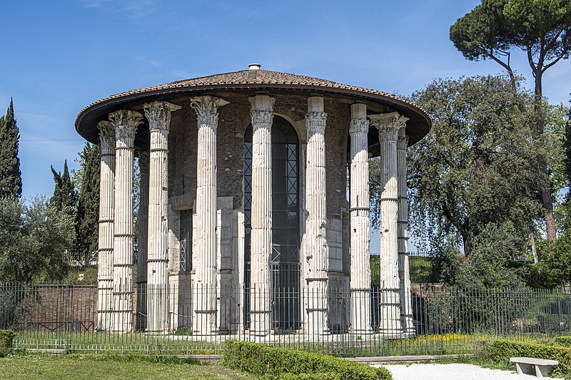
.gif)
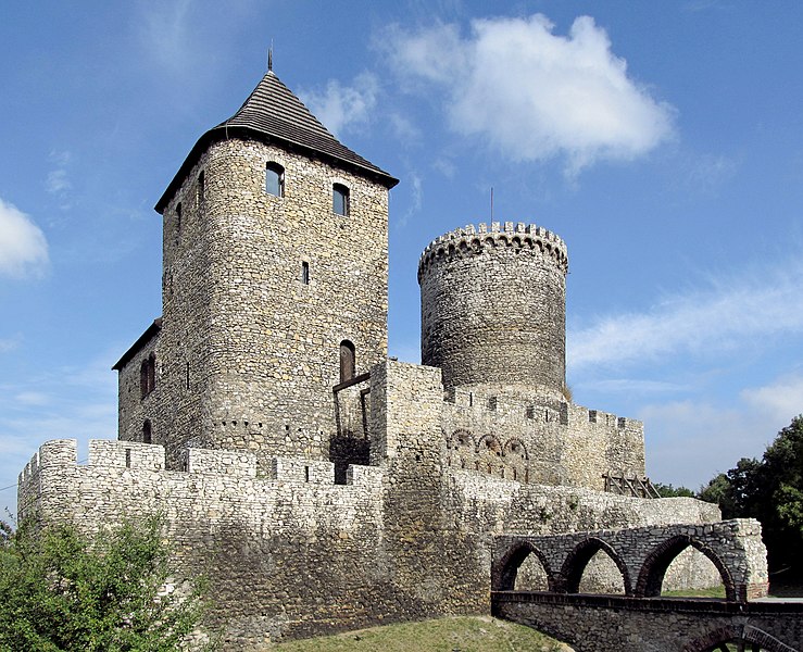
.jpg)
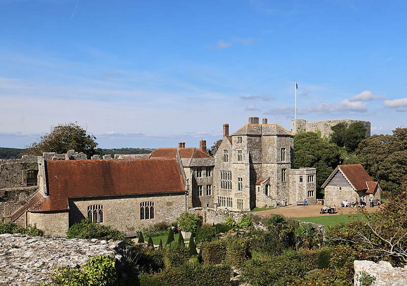
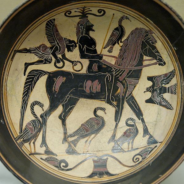
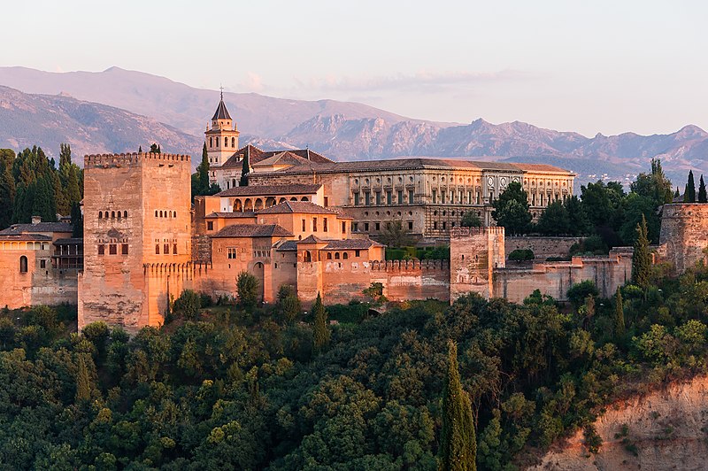
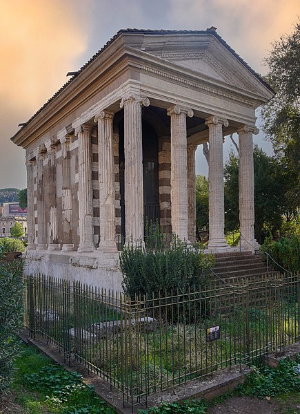
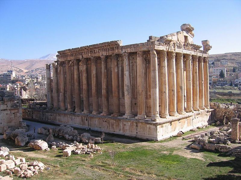
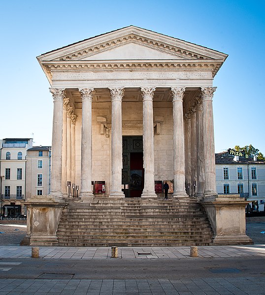
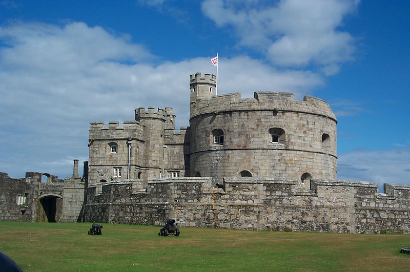
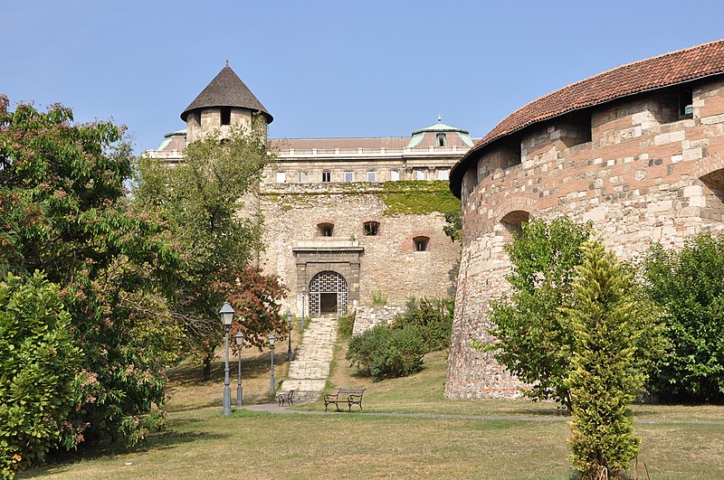
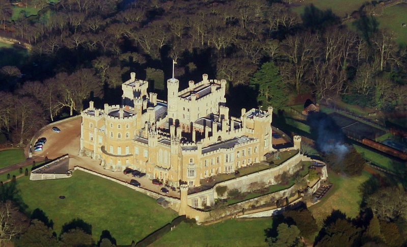
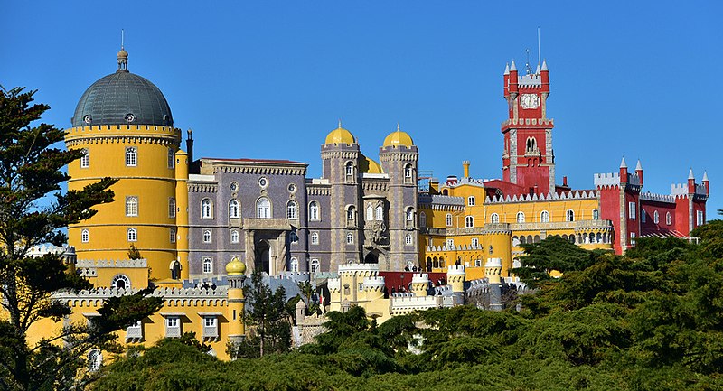
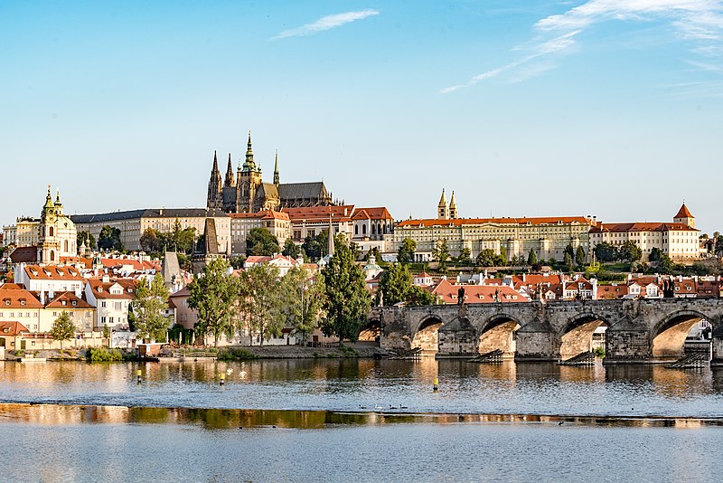
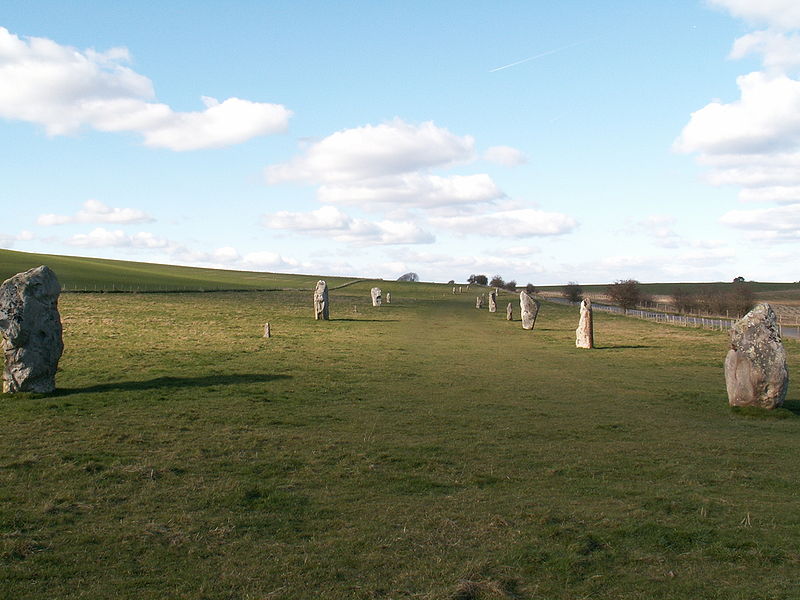
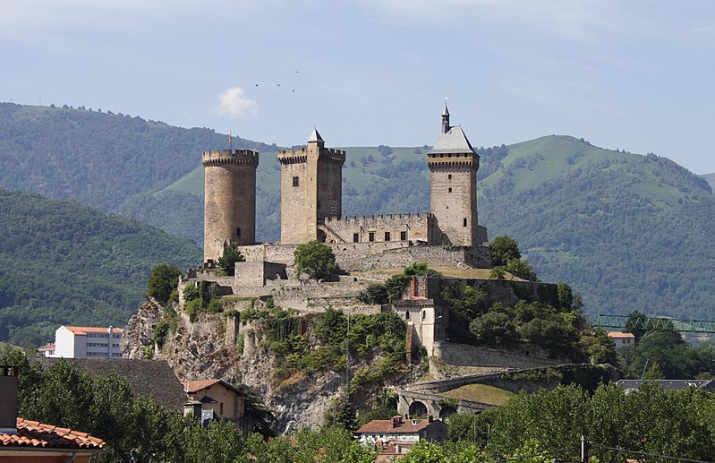
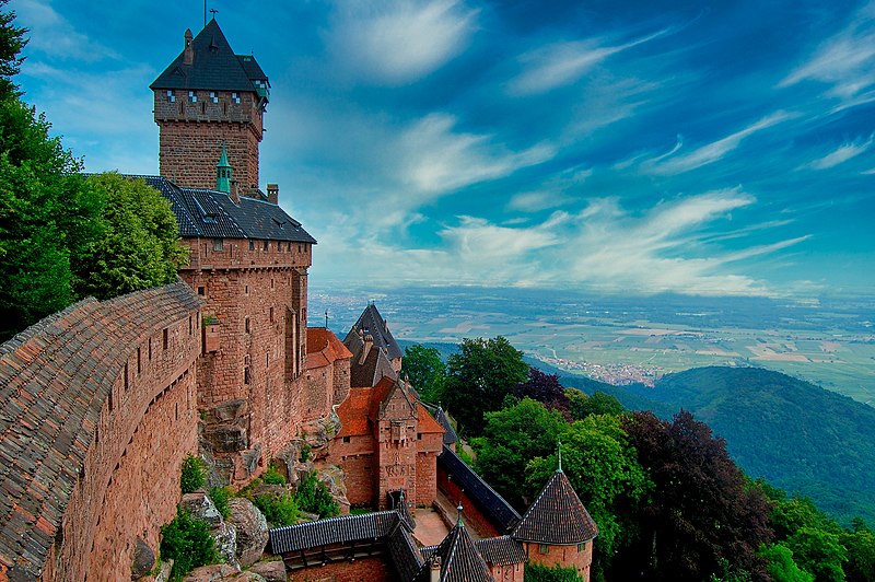
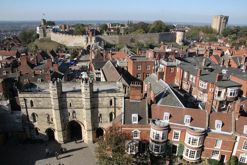
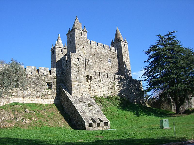
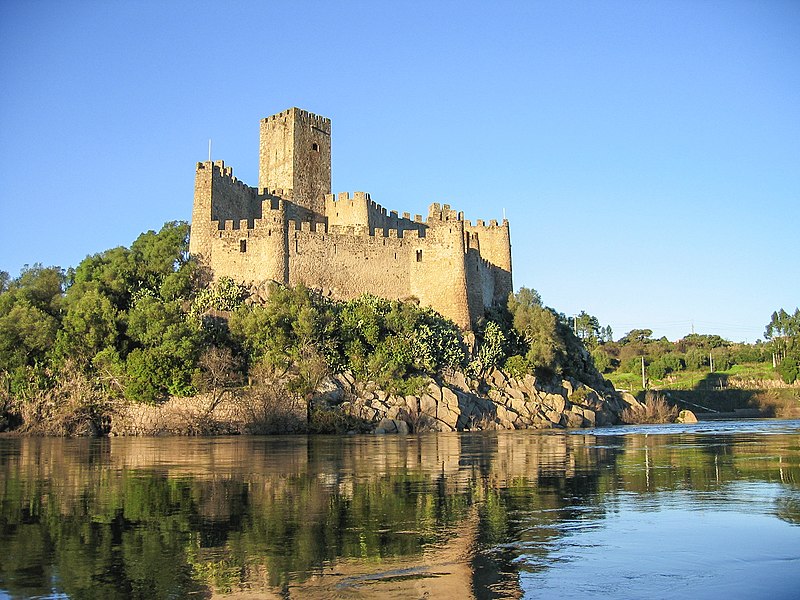
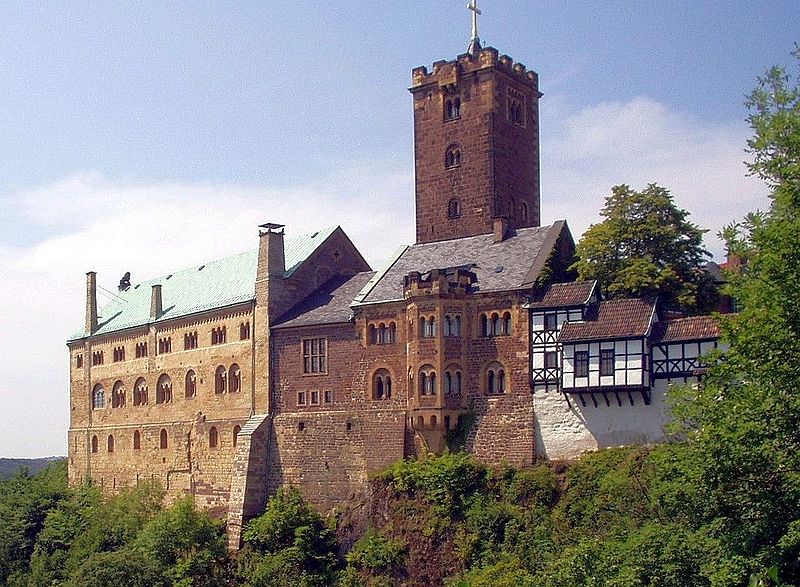
.jpg)
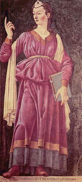
.jpg)
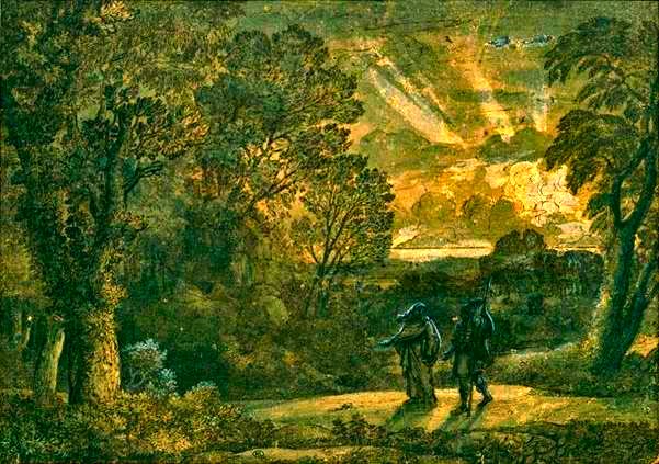
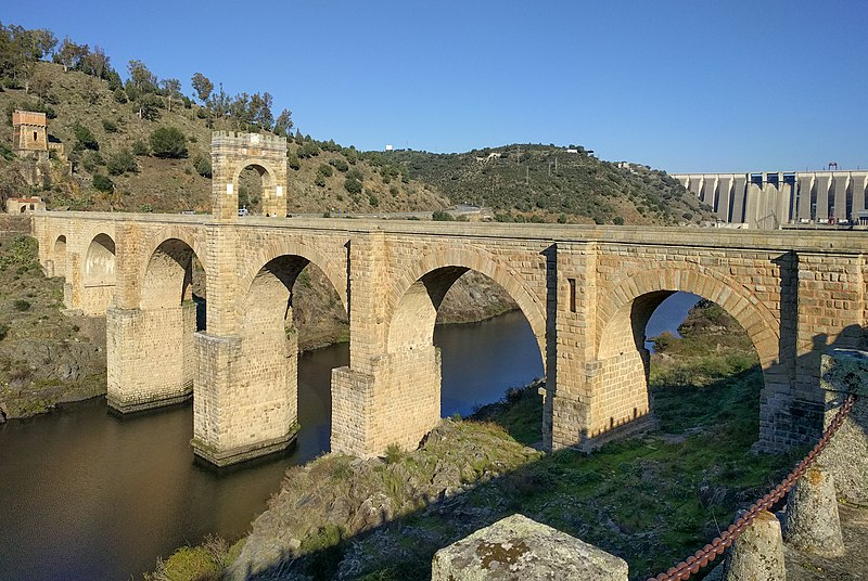
.jpg)
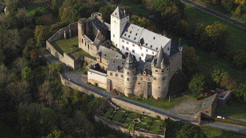

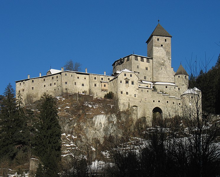
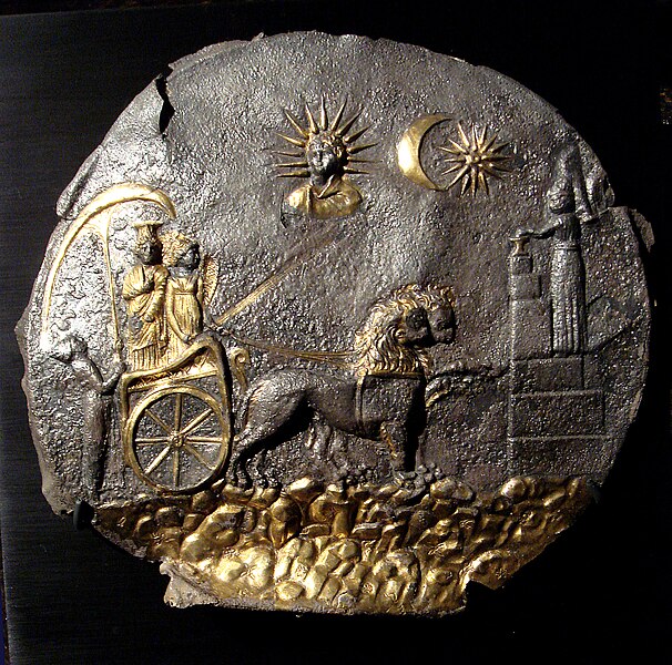
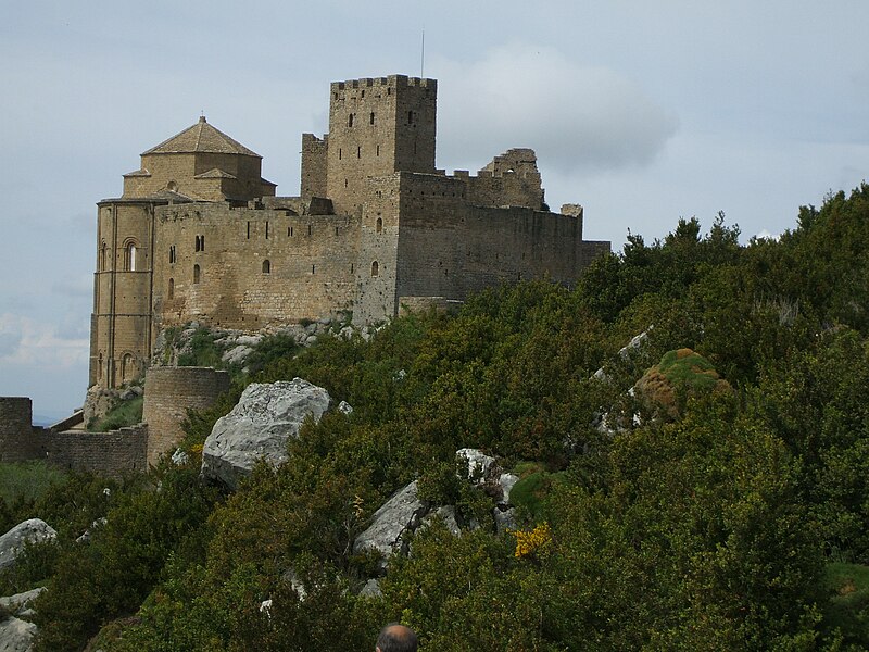

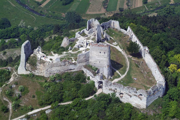
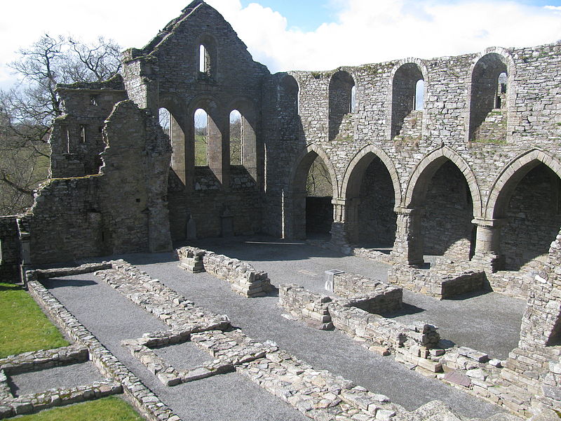
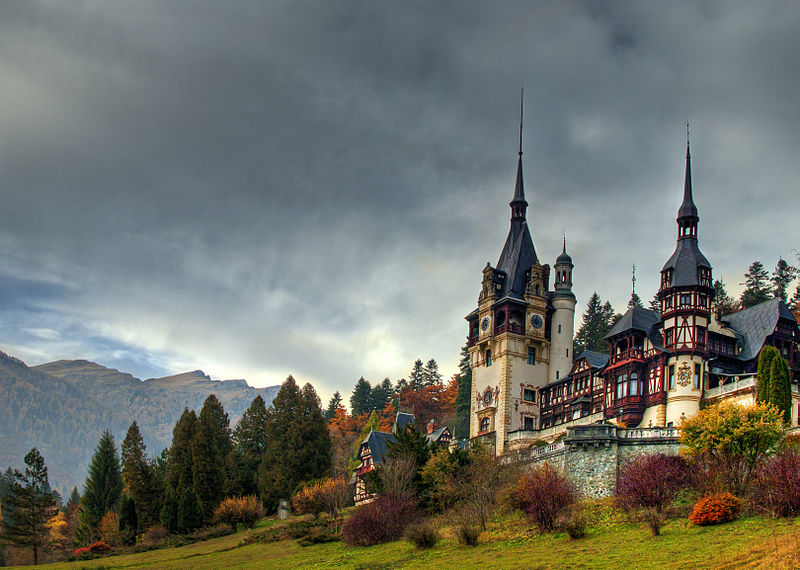
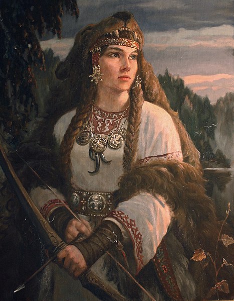
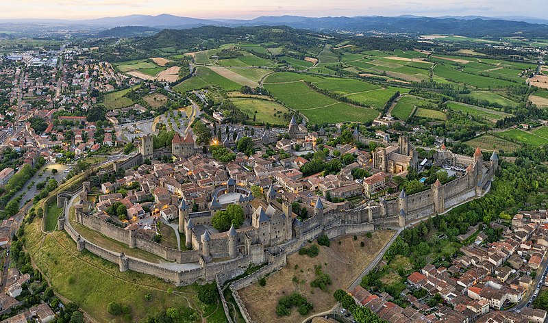
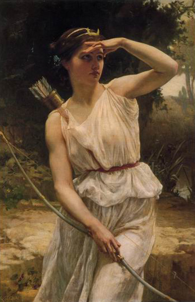
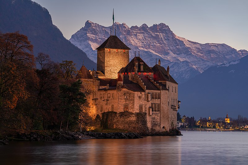
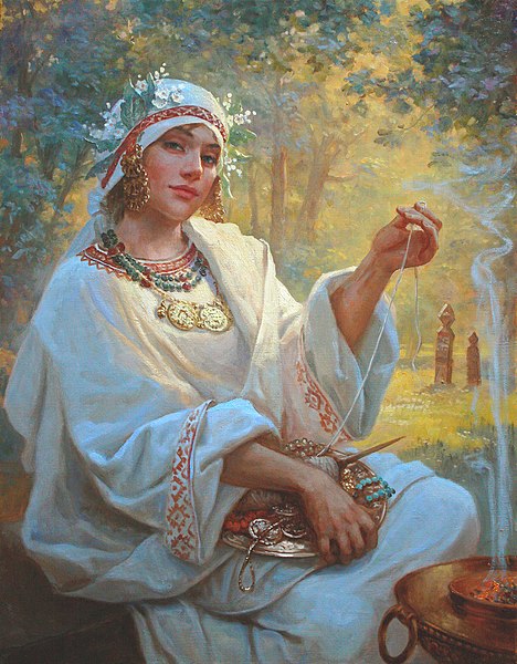


.jpg)
_vector.svg.png)

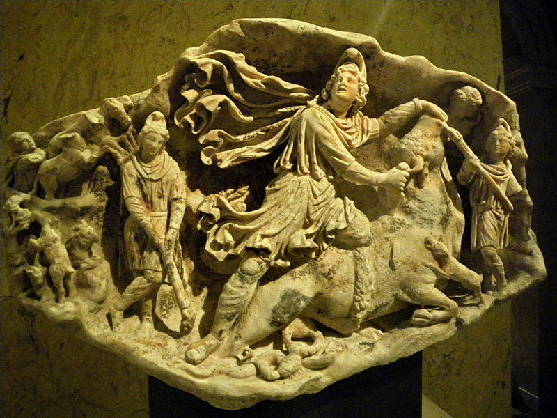
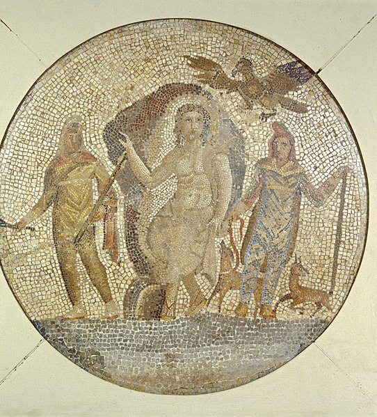
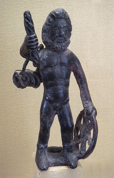

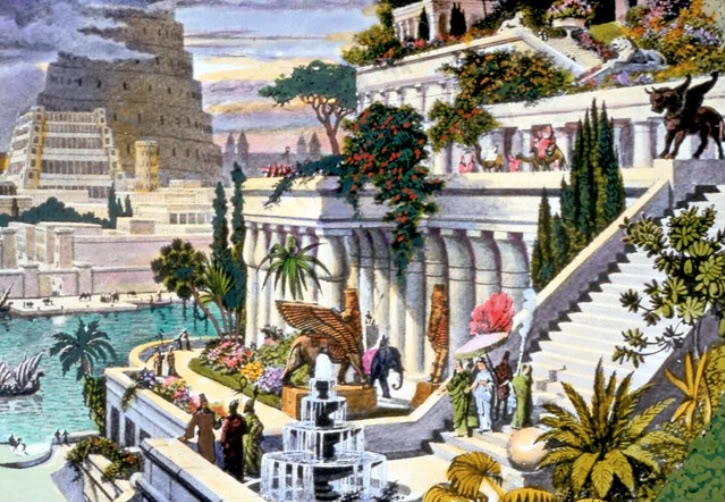
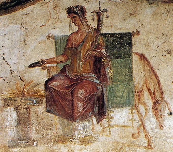
.jpg)